California as an Island: A Map Error Preserved in Print
The Reading Room Published
Short answer
California as an island is a mapping error: a sea strait drawn between California and the mainland. Of nine public-domain maps read here, four show the island, all dated 1636 to 1705.
Viewing card
- Where
- California and the Gulf of California, as drawn on nine printed maps dated 1548 to 1752
- Seen from
- Printed maps, engraved and in most copies hand-colored, read from scans uploaded by the University of Texas at Arlington Libraries
- Captured
- Map dates 1548 to 1752 per the Commons file pages; modern coastline from Natural Earth 1:50m, VERSION file 5.2.0-pre
- Reading altitude
- On a map: the whole Gulf of California in view, from the southern tip of the peninsula to the gulf's northern end, to see whether water or land closes it off
- Written by
- Mapmakers who drew a strait behind California on four maps of 1636 to 1705 in this set; the 1636 map's own note credits a Spanish map taken by the Dutch
This card as data (CSV) About this file
Data: Commons file pages (public-domain maps) and Natural Earth (public domain), read 2026-11-16
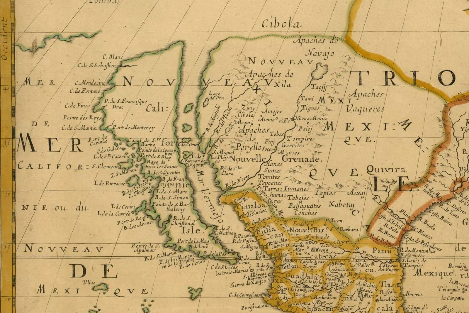
California as an island on Nicolas Sanson's map of North America, dated Paris, 1650, in its title cartouche. Water runs all the way around the land labeled Californie.
"Amerique Septentrionale (detail: California and the Mar Vermejo), map by Nicolas Sanson, Paris, 1650" by Nicolas Sanson — https://commons.wikimedia.org/wiki/File:Sanson_Amerique_Septentrionale_1650_UTA.jpg — Public domain (US: first published 1650, before 1931; EU: mapmaker Nicolas Sanson died 1667, more than 70 years ago); modified: cropped, resized
On an old engraved map, open sea cuts California off from the rest of North America. Read in order of printing, maps like this one show that the error was in print by the 1630s and how long it stayed. Nicolas Sanson's 1650 map of North America, signed by the engraver Peyrounin, puts the Mar Vermejo on one side of the land and the Pacific on the other, with water across the top.
An error like this is evidence of what a mapmaker had to work with. It needs neither mocking nor excusing. A row of dated maps can show when it appears and when it fades, at least within that row.
Map by map: when was California an island?
The nine maps below come from one source: scans that the University of Texas at Arlington Libraries uploaded to Wikimedia Commons. File pages give each map's date and the mapmaker's death year, and mark the scan public domain. Each scan was read for one feature only, at the top of the Gulf of California: does water run on past the land, or does land close the gulf?
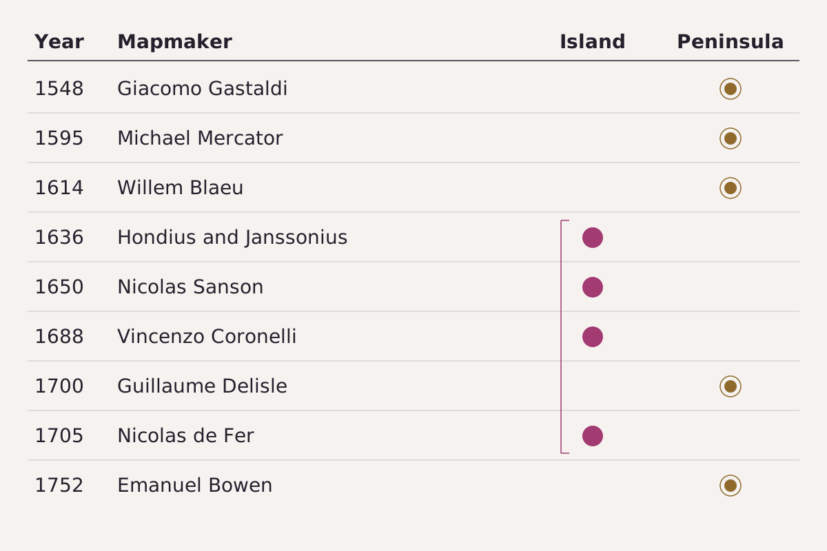
Nine printed maps in date order, each read for one feature: whether water or land closes the Gulf of California at its north end. Filled dots mark an island, ringed dots a peninsula.
Benchmark Each row taken from this page's CSV; years, mapmakers and readings in the table.
"California on nine printed maps, 1548 to 1752: island or peninsula" by Meridian & Moraine, https://meridianandmoraine.com/contours/california-as-an-island/, licensed under CC BY 4.0 (https://creativecommons.org/licenses/by/4.0/).
Data: Map dates and makers from the Wikimedia Commons file pages of nine University of Texas at Arlington Libraries scans; island or peninsula read on each scan, 2026-11-16
| Year | Mapmaker | California shown as |
|---|---|---|
| 1548 | Giacomo Gastaldi | peninsula |
| 1595 | Michael Mercator | peninsula |
| 1614 | Willem Blaeu | peninsula |
| 1636 | Henricus Hondius and Joannes Janssonius | island |
| 1650 | Nicolas Sanson | island |
| 1688 | Vincenzo Coronelli | island |
| 1700 | Guillaume Delisle | peninsula |
| 1705 | Nicolas de Fer | island |
| 1752 | Emanuel Bowen | peninsula |
Download the map timeline (CSV) (about this file) Data: Map records from Wikimedia Commons file pages (University of Texas at Arlington Libraries uploads), read 2026-11-16
Which maps show California as an island? In this set, Willem Blaeu's map, dated 1614 on its file page and printed in Blaeu atlases from 1617, still joins California to the mainland. The 1636 map by Hondius and Janssonius is the earliest readable map in this set that cuts it free, and the island holds on Sanson's map of 1650 and Vincenzo Coronelli's of 1688. Nine maps are a sample, not a census, so these years bound the error only within this set.
When did maps stop showing it? The set gives no single year. Guillaume Delisle's map of 1700, scanned here in a later state, closes the gulf with land, while Nicolas de Fer's map of 1705, also printed in Paris, still runs open water up the east side of California and off the top of the sheet. Two Paris maps five years apart disagree, and by Emanuel Bowen's map of 1752 the peninsula is back.
Delisle's sheet also shows a different habit at work. It joins California to the mainland but leaves the far northwest of the continent as empty paper, with no coast drawn above the last named capes. A blank of that kind is a cut too, but an honest one: according to the scan's Commons description, Delisle left that area empty because no reliable information was yet available.
Another engraver's island
The 1636 map America Septentrionalis, by the Amsterdam mapmakers Henricus Hondius and Joannes Janssonius, labels the land Insula California and the water east of it Mare Vermeio. Above the island, a Latin note gives the mapmakers' own reason for the shape.
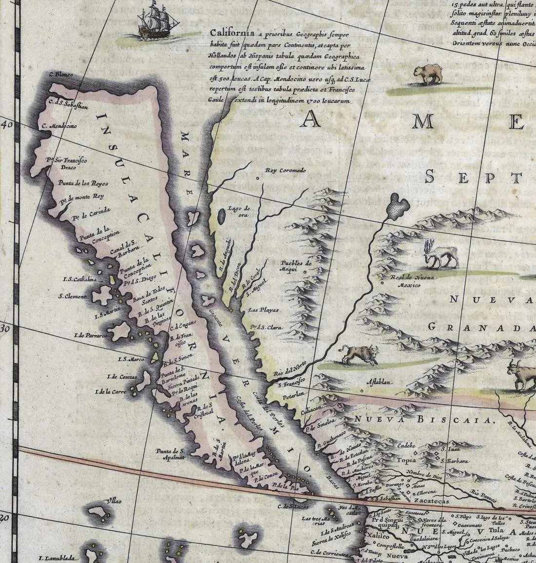
California as an island on the 1636 America Septentrionalis by Hondius and Janssonius. The Latin note above the island says where the outline came from.
"America Septentrionalis (detail: Insula California and the Latin note), map by Henricus Hondius and Joannes Janssonius, 1636" by Henricus Hondius and Joannes Janssonius — https://commons.wikimedia.org/wiki/File:Hondius-Jansson_America_Septentrionalis_1636_UTA.jpg — Public domain (US: first published 1636, before 1931; EU: mapmakers Henricus Hondius II (died 1651) and Joannes Janssonius (died 1664), more than 70 years ago); modified: cropped, resized
The note opens: “California a prioribus Geographis semper habita fuit quaedam pars Continentis, at capta per Hollandos ab Hispanis tabula quaedam Geographica compertum est insulam esse …” In this page's translation: California was always held by earlier geographers to be part of the continent, but from a map taken from the Spaniards by the Dutch, it was found to be an island …
Why did mapmakers draw California as an island? According to this note, the outline came from a captured Spanish map. The note is the mapmakers' own claim, and this page could not read the Spanish map it names. The map alone cannot tell whether that source was wrong, misread, or never existed as described.
The note does name the cartographer's cut on this sheet: an outline taken from another map and printed as fact. Every map leaves things out or bends them, but here, by the note's own account, the cut is a copied coastline. The mountains on the same sheet are rows of small hills drawn side-on, a long way from shaded relief, which draws the same kind of ground with light and shadow.
Old outline, real coastline
A modern coastline shows what the island maps missed. In the public-domain Natural Earth 1:50m coastline (version file 5.2.0-pre), the Gulf of California ends in land near 31.9°N. That northern end lies about 1,120 km from the southern tip of the peninsula, measured as a great-circle line between the two points.
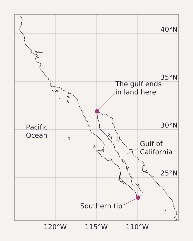
The modern coastline from Natural Earth, drawn for comparison and not fitted to any old map. The Gulf of California ends in land at the upper dot, near 31.9°N.
Benchmark Coastline from Natural Earth 1:50m data, version file 5.2.0-pre; the 1,120 km distance is a great circle on a sphere of radius 6,371 km; longitude scaled by the cosine of 31.25°N.
"Modern coastline of California and the Gulf of California" by Meridian & Moraine, https://meridianandmoraine.com/contours/california-as-an-island/, licensed under CC BY 4.0 (https://creativecommons.org/licenses/by/4.0/).
Data: Made with Natural Earth: 1:50m coastline, public domain (natural-earth-vector repository, VERSION 5.2.0-pre), read 2026-11-16
Put the 1636 outline beside it, and the strait runs where the modern line shows land north of the gulf. None of these old maps gives heights, either. A modern sheet records height with contour lines, each one joining points at the same elevation.
Emanuel Bowen's 1752 map of Mexico or New Spain draws the peninsula and prints its own account of the change. The note at the top reads: “California, which has been Described and Represented as an Island, even by very modern Geographers, was Discover’d by Father Eusebius Francis Kino a Jesuit, to be a Peninsula between the Years 1698 and 1701 …”
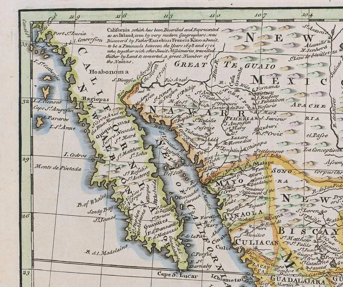
California joined to the mainland on Emanuel Bowen's 1752 map of Mexico or New Spain. The English note at the top gives the map's account of the change.
"A New & Accurate Map of Mexico or New Spain together with California, New Mexico &c. (detail: California and the note), map by Emanuel Bowen, 1752" by Emanuel Bowen — https://commons.wikimedia.org/wiki/File:Bowen_Mexico_or_New_Spain_1752_UTA.jpg — Public domain (US: first published 1752, before 1931; EU: mapmaker Emanuel Bowen died 1767, more than 70 years ago); modified: cropped
The note is Bowen's account, printed half a century after the years it names. This page did not read Kino's own reports, so the finding stands here as Bowen's claim. Even so, the note records something missing from the timeline: in 1752 an English mapmaker still thought island drawings by recent geographers worth correcting.
On any old map of North America, find the Gulf of California and trace its western shore north with a finger. If land closes the water, the map draws a peninsula. If the water keeps going past the top of California, or off the sheet, check the date in the title and see where it falls in the table above.
Next overpass
- How to read a topographic map: a modern sheet states its date, interval and symbols in the margin, and this is how to read them.
- How to read a geologic map: another old map that changed how people read the ground, William Smith's map of 1815.
Sources
- Nicolas Sanson, Amerique Septentrionale (Paris, 1650), engraved by Peyrounin; scan by the University of Texas at Arlington Libraries, Wikimedia Commons file Sanson_Amerique_Septentrionale_1650_UTA.jpg. commons.wikimedia.org/wiki/File:Sanson_Amerique_Septent…Read: file page in full and the whole map from the original scan
- Giacomo Gastaldi, Nueva Hispania Tabula Nova, in La Geografia di Claudio Ptolomeo Alessandrino (Venice, 1548); scan by the University of Texas at Arlington Libraries, Wikimedia Commons file Gastaldi_Nueva_Hispania_Tabula_Nova_1548_UTA.jpg. commons.wikimedia.org/wiki/File:Gastaldi_Nueva_Hispania…Read: file page in full and the whole map from the original scan
- Michael Mercator, America sive India Nova (Amsterdam: Jodocus Hondius, 1595); scan by the University of Texas at Arlington Libraries, Wikimedia Commons file Mercator_America_Sive_India_Nova_1595_UTA.jpg. commons.wikimedia.org/wiki/File:Mercator_America_Sive_I…Read: file page in full and the whole map from the original scan
- Willem Blaeu, Americae Nova Tabula (Amsterdam, dated 1614 on the file page; in Blaeu atlases from 1617); scan by the University of Texas at Arlington Libraries, Wikimedia Commons file Blaeu_Americae_Nova_Tabula_1614_(1617)_UTA.jpg. commons.wikimedia.org/wiki/File:Blaeu_Americae_Nova_Tab…Read: file page in full and the whole map from the original scan
- Henricus Hondius and Joannes Janssonius, America Septentrionalis (Amsterdam, 1636); scan by the University of Texas at Arlington Libraries, Wikimedia Commons file Hondius-Jansson_America_Septentrionalis_1636_UTA.jpg. commons.wikimedia.org/wiki/File:Hondius-Jansson_America…Read: file page in full and the whole map from the original scan, with the Latin note on California read word by word
- Vincenzo Coronelli, America Settentrionale colle nuove scoperte fin all'anno 1688 (Venice, 1688); scan by the University of Texas at Arlington Libraries, Wikimedia Commons file Coronelli_America_Settentrionale_Colle_Nuove_Scoperti_fin_all'_Anno_1688_UTA.jpg. commons.wikimedia.org/wiki/File:Coronelli_America_Sette…Read: file page in full and the whole map from the original scan
- Guillaume Delisle, L'Amerique Septentrionale (Paris, 1700; later state, 1709 per the file name); scan by the University of Texas at Arlington Libraries, Wikimedia Commons file Delisle_L'Amerique_Septentrionale_1700_(1709)_UTA.jpg. commons.wikimedia.org/wiki/File:Delisle_L%27Amerique_Se…Read: file page in full and the whole map from the original scan
- Nicolas de Fer, Cette carte de Californie et du Nouveau Mexique (Paris, 1705), engraved by C. Inselin; scan by the University of Texas at Arlington Libraries, Wikimedia Commons file De_Fer_Cette_Carte_de_Californie_et_du_Nouveau_Mexique_1705_UTA.jpg. commons.wikimedia.org/wiki/File:De_Fer_Cette_Carte_de_C…Read: file page in full and the whole map from the original scan
- Emanuel Bowen, A New & Accurate Map of Mexico or New Spain together with California, New Mexico &c. (1752); scan by the University of Texas at Arlington Libraries, Wikimedia Commons file Bowen_Mexico_or_New_Spain_1752_UTA.jpg. commons.wikimedia.org/wiki/File:Bowen_Mexico_or_New_Spa…Read: file page in full and the whole map from the original scan, with the English note on California read word by word
- Natural Earth, 1:50m coastline (ne_50m_coastline), natural-earth-vector repository, VERSION file 5.2.0-pre. Public domain. github.com/nvkelso/natural-earth-vectorRead: full text of the license and version files; the whole 1:50m coastline dataset


Cite this page
The Reading Room. “California as an Island: A Map Error Preserved in Print.” Meridian & Moraine, published 16 November 2026. https://meridianandmoraine.com/contours/california-as-an-island/. Accessed on the date you read it.
How readings are checkedAll correctionsReport an error on this page (contact@meridianandmoraine.com)
More from Contours & Charts
Contours & Charts
Contour Lines: A V Pointing Uphill Marks a Stream Valley
Image credit
"Skykomish, Washington, topographic sheet (detail near Baring), 1902" by U.S. Geological Survey — https://commons.wikimedia.org/wiki/File:1902_USGS_topo_map_of_Baring,_Washington.jpg — Public domain (US: U.S. Government work (17 U.S.C. §105), USGS topographic sheet published 1902; EU: published 1902 by a U.S. federal agency, more than 70 years ago); modified: cropped
Contours & Charts
How to Read a Topographic Map: Start With the Interval
Image credit
"Teton Range crest (detail), from Grand Teton Quadrangle, Wyoming, USGS topographic sheet, 1929 printing" by U.S. Geological Survey — https://commons.wikimedia.org/wiki/File:1929_U.S.G.S._Map_of_Grand_Teton_National_Park,_Wyoming_-_Geographicus_-_GrandTeton-USGS-1929.jpg — Public domain (US: U.S. Government work (17 U.S.C. §105), USGS topographic sheet surveyed 1899 and first published 1901, this printing 1929 with National Park Service additions; EU: published by U.S. federal agencies more than 70 years ago); modified: cropped, rotated
Contours & Charts
Shaded Relief: Why Maps Light Mountains From the Northwest
Image credit
"Blatt XVIII, Brieg, Airolo (detail around the Aletsch glaciers), from Topographische Karte der Schweiz (Dufour Map), 1854, by Guillaume-Henri Dufour and the Eidgenössisches Topographisches Bureau" by Federal Office of Topography swisstopo — https://commons.wikimedia.org/wiki/File:Swisstopo_Dufourkarte_BLATT_XVIII_BRIEG_AIROLO_LT_TK_018_1854.tiff — swisstopo terms of use for free geodata (https://www.swisstopo.admin.ch/en/terms-of-use-free-geodata-and-geoservices); modified: cropped, resized; rights notice: ©swisstopo