Columnar Basalt: Not Every Causeway Column Is a Hexagon
The Reading Room Published
Short answer
Columnar basalt is lava that cracked into long columns as it cooled and shrank. In one mapped stretch of the Giant's Causeway, most column tops have five, six or seven sides, not only six.
Viewing card
- Where
- Giant's Causeway, Northern Ireland (per USGS), in County Antrim (per the photochrom record)
- Seen from
- Ground level on the shore, looking across the column tops, in three photographs
- Captured
- Albumen print by Robert French, about 1865; photochrom, 1890 to 1900; USGS photograph by Daniel Muhs, media page dated August 6, 2019
- Reading altitude
- From ground level on the shore, looking across the column tops, as in the three photographs
- Written by
- Lava flows about 62 to 63 million years old (per USGS) that split into columns as they cooled and shrank
This card as data (CSV) About this file
Data: USGS (public domain); Akiba et al. (2021, 2017) cited by source id, read 2026-11-16
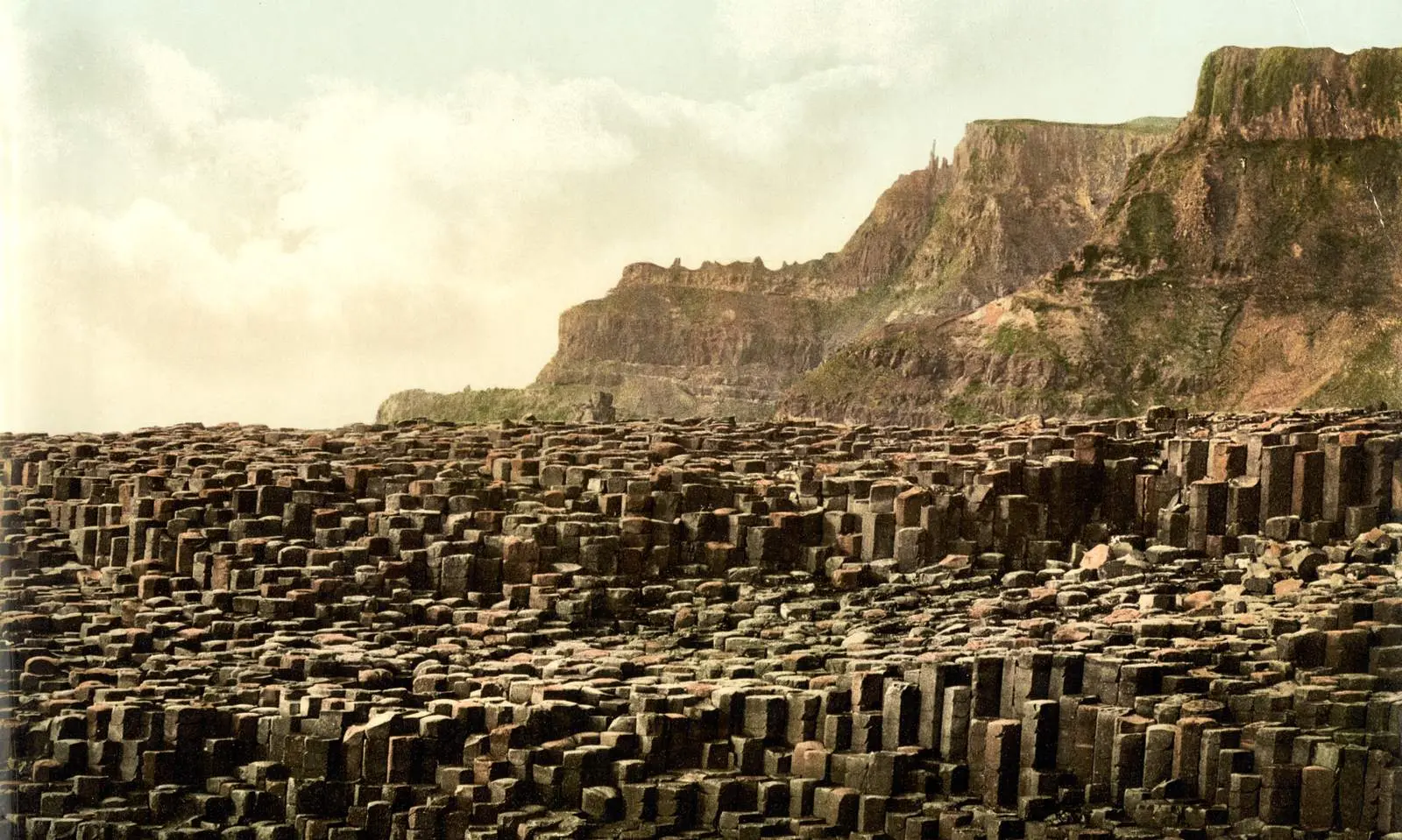
The Giant's Causeway in County Antrim, in a photochrom printed between 1890 and 1900. Column tops crowd the shore below the cliffs.
"Giant's Causeway, County Antrim, Ireland, photochrom published by the Detroit Publishing Co. under license from Photoglob Zürich" by Unknown author — https://commons.wikimedia.org/wiki/File:Giant%27s_Causeway,_County_Antrim,_Ireland,_1890s.jpg — Public domain (US: published before 1931 (photochrom printed between 1890 and 1900); EU: anonymous work, photographer not named, first published more than 70 years ago); modified: cropped, resized
At the water's edge, the tops of tightly packed stone columns form a floor of many-sided paving stones. Count the corners on a few and the hexagon turns out to be one shape among several. A study by E. A. Jagla and A. G. Rojo, published in Physical Review E in 2002, compared a mapped stretch of the Giant's Causeway with simulated crack patterns and found mostly five-, six- and seven-sided polygons in both.
How do the columns form?
The columns are blocks of rock left between cracks. In a 2021 paper, Yuri Akiba, Aika Takashima and Hiroyuki Shima describe the broadly accepted view: a solidified lava flow keeps cooling and contracting, and shrinkage cracks open and push inward. A 2017 paper by Akiba and colleagues adds that cooling starts at both the top and the bottom surface of a pooled flow, so cracks grow in from both sides.
The pattern changes with depth. Near the surface, the first cracks form a random network, and most junctions are T-shaped, where a new crack stops against an older one. Deeper down, according to the 2021 paper, the junctions turn into Y-shapes where three cracks meet. The cross sections of the columns even out into polygons of similar size, and hexagons become the favored shape.
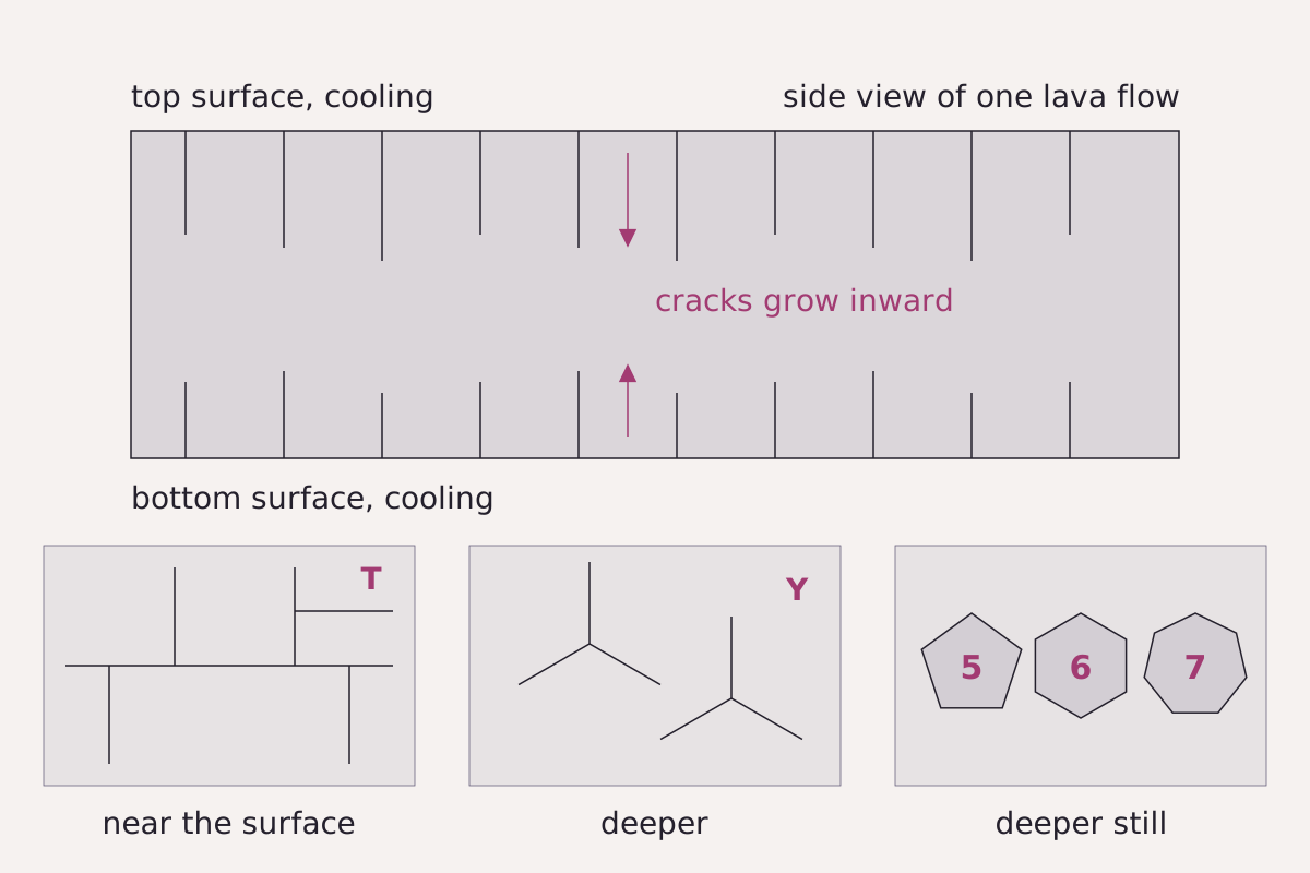
A cooling lava flow in side view, cracking inward from both surfaces. The three panels below look down on the crack network at increasing depth: T-shaped junctions, then Y-shaped junctions, then near-equal polygons with five, six or seven sides.
Benchmark Schematic, not to scale; T-to-Y junction sequence from Akiba et al. (2021), cooling at top and bottom surfaces from Akiba et al. (2017).
"How columnar joints form: cracks growing inward from the cooling surfaces" by Meridian & Moraine, https://meridianandmoraine.com/strata/columnar-basalt/, licensed under CC BY 4.0 (https://creativecommons.org/licenses/by/4.0/).
Data: Paraphrased from Akiba et al. (2021) and Akiba et al. (2017), arXiv, read 2026-11-16
Read the top of a flow as a rough draft and the deeper levels as a fair copy in the same hand. In physical terms, Jagla and Rojo model the tidying as the crack network moving toward a layout that releases more stored elastic energy. Following earlier work by Ryan and Sammis, they also point to marks on the sides of the columns, called striae or chisel marks, as a sign that the crack front advanced in steps rather than smoothly.
How many sides does a column have?
The hexagon has a physical reason behind it. Jagla and Rojo cite a known result: for a fixed total length of cracks, an ideal honeycomb of hexagons allows the rock to shed the most elastic energy. In their comparison, real crack patterns do not reach that ideal. The 2021 paper by Akiba and colleagues says a sizable share of the polygons in real columnar joints are not hexagons, and traces part of that irregularity to the random cracking of the early stage.
For the Giant's Causeway itself, Jagla and Rojo worked from a map of the column pattern originally drawn by J. P. O'Reilly in 1879. Their text sums up the side histogram: most polygons have five, six or seven sides, and a minor share have four or eight. The paper shows those frequencies only as a bar chart, so this page reports the grouping without percentages.
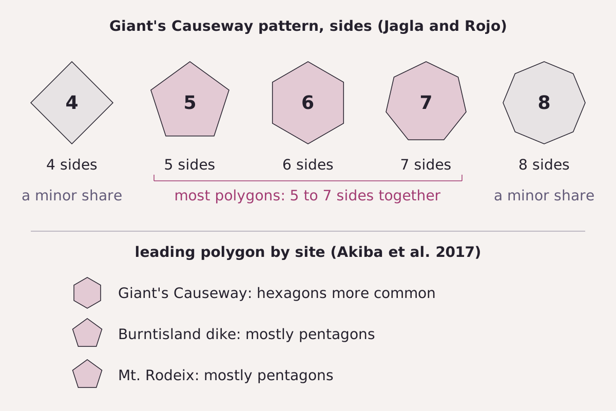
What the studies report about side numbers. Top: the Giant's Causeway pattern studied by Jagla and Rojo. Bottom: the polygon that leads at three sites, as summarized by Akiba and colleagues in 2017.
Benchmark Each label taken from this page's CSV, site names shortened; sources in the table, qualifiers in the CSV.
"Side numbers of column tops: what the studies report" by Meridian & Moraine, https://meridianandmoraine.com/strata/columnar-basalt/, licensed under CC BY 4.0 (https://creativecommons.org/licenses/by/4.0/).
Data: Paraphrased from Jagla and Rojo (2002) and Akiba et al. (2017), arXiv, read 2026-11-16
The 2017 paper by Akiba and colleagues adds a comparison between sites. Its summary of earlier field studies puts hexagons as more common at the Giant's Causeway, and mostly pentagons at the Burntisland dike in Scotland and the Mt. Rodeix basalt in France. The same paper notes a proposal that the leading side number depends on cooling rate, with pentagons favored by faster cooling and hexagons by slower cooling.
| Sides | What the study reports | Site | Study |
|---|---|---|---|
| 6 | Hexagons more common | Giant's Causeway | Akiba et al. 2017 |
| 5 to 7 | Most polygons | Giant's Causeway (O'Reilly map) | Jagla and Rojo 2002 |
| 4 and 8 | A minor share | Giant's Causeway (O'Reilly map) | Jagla and Rojo 2002 |
| 5 | Mostly pentagons | Burntisland dike, Scotland | Akiba et al. 2017 |
| 5 | Mostly pentagons | Mt. Rodeix, France | Akiba et al. 2017 |
| All classes | 1,069 polygons counted | Tatami-Ishi, Okinawa, Japan (andesite) | Akiba et al. 2021 |
| All classes | 894 polygons counted | Yamaguchi, Japan (trachybasalt) | Akiba et al. 2021 |
| All classes | 1,012 polygons counted | Hino-Misaki, Shimane, Japan (rhyolite) | Akiba et al. 2021 |
| All classes | 3,987 polygons counted | Shizuoka, Japan (andesite) | Akiba et al. 2021 |
Download the side-number claims (CSV) (about this file) Data: Single values and paraphrased statements from Akiba et al. (2021, 2017) and Jagla and Rojo (2002), arXiv, read 2026-11-16
Columns are not limited to basalt. The four sites in Japan in the 2021 paper by Akiba and colleagues are andesite, trachybasalt and rhyolite, with mean column diameters from 5.22 cm at Hino-Misaki to 1.78 m at Tatami-Ishi. The same kind of polygonal cracking appears in the lab. The 2017 paper studies drying starch slurries that split into prism-shaped columns, and Jagla and Rojo put such starch columns in the millimeter range.
The Causeway today
A U.S. Geological Survey photograph, posted on a USGS media page dated August 6, 2019, shows the tops of the Causeway columns up close. The USGS page says the basalt flows here are about 62–63 million years old. It also says erosion has planed the tops off nearly to sea level, which gives them their quasi-circular outlines.
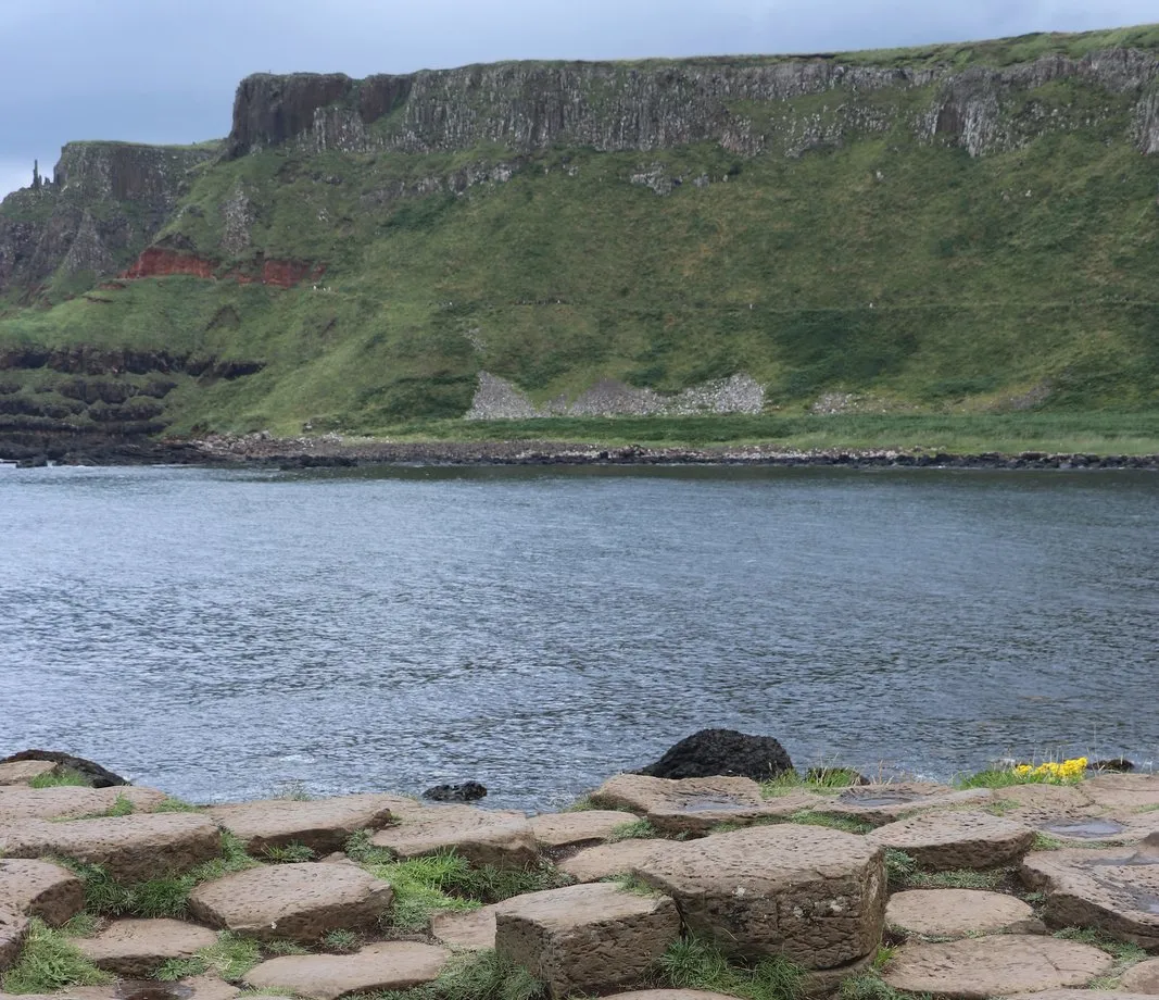
Column tops at the Giant's Causeway, from a USGS media page posted in 2019. That page says erosion has planed these tops down nearly to sea level.
"Giant's Causeway Geology" by Daniel Muhs, U.S. Geological Survey — https://www.usgs.gov/media/images/giants-causeway-geology — Public domain (US: U.S. Government work (17 U.S.C. §105), photograph by a USGS research geologist, page marked 'Sources/Usage: Public Domain'; EU: no copyright claimed by the U.S. Government publisher, released as public domain); modified: cropped, resized
The rounded tops are wear, then, not the shape of the original cracks. The same USGS page says the basalt formed when molten mantle material reached the surface and solidified, as the Mid-Atlantic Ridge was pushing North America and Europe apart. It adds that the process still goes on today in Iceland, which is built mostly of basalt but is much younger.
Wet column tops at the shore are best read from the public path or a viewpoint above the shore, and this page gives no route across the stones. Other coastal outcrops on this site read the same way from a safe distance, such as the Lulworth Crumple and its folded beds. To see how lava flows like these are drawn as rock units on paper, turn to how to read a geologic map.
An older view of the columns
Robert French photographed a stretch of the Causeway around 1865 for an albumen print titled The Honeycombs, now in the Los Angeles County Museum of Art. The title already carries the hexagon idea. In the print, stepped stacks of columns rise beyond a pool and boulders, and the nearest tops sit in the water.
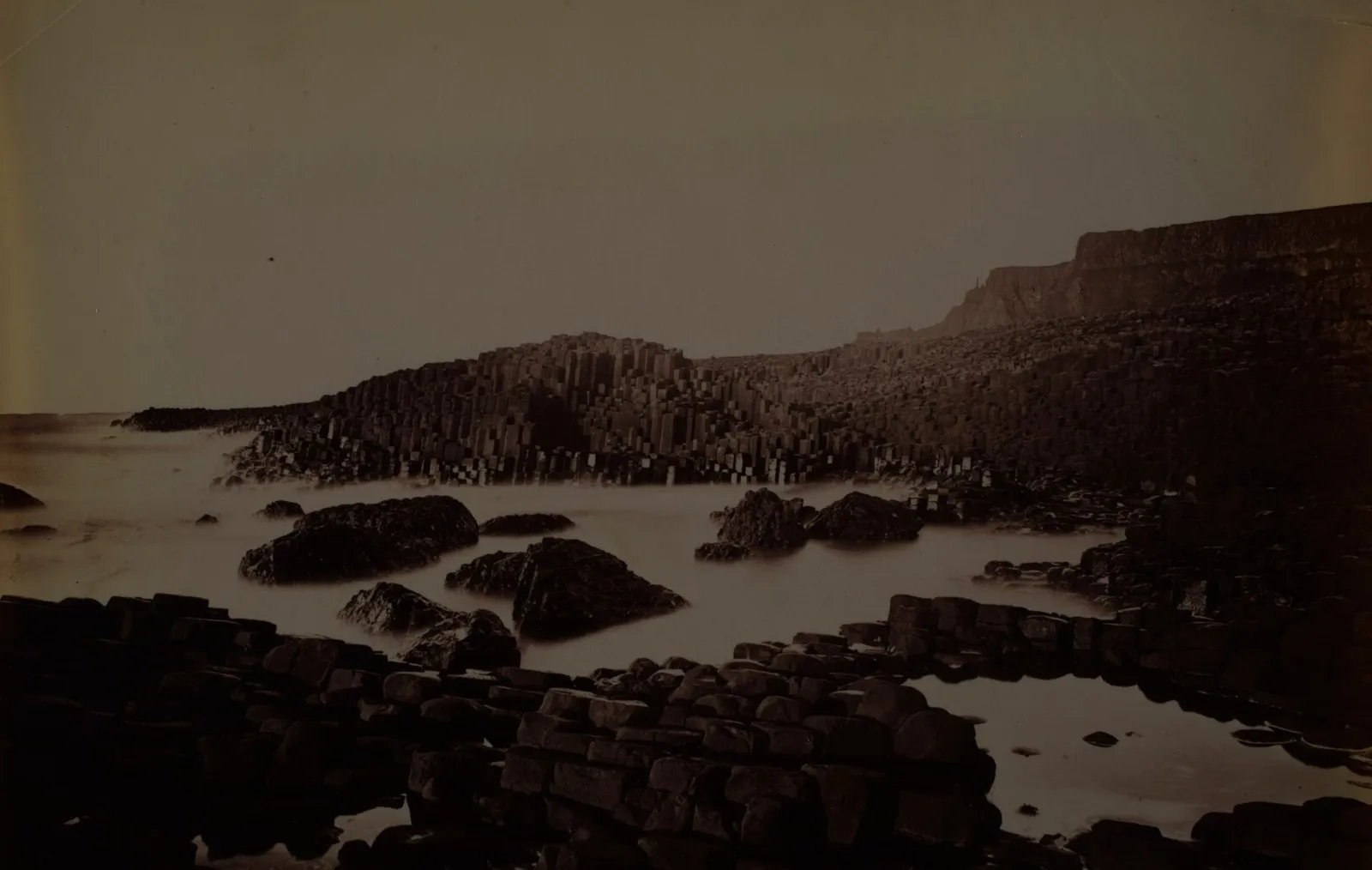
The Honeycombs, Giant's Causeway, an albumen print dated about 1865 in the museum record. Column stacks rise beyond the water.
"The Honeycombs, Giants Causeway (albumen print)" by Robert French — https://commons.wikimedia.org/wiki/File:The_Honeycombs,_Giants_Causeway_LACMA_M.2008.40.867.jpg — Public domain (US: printed about 1865, published before 1931; EU: photographer Robert French died 1917, more than 70 years ago); modified: cropped, resized
Side by side with the 1890s photochrom and the USGS photograph, the print shows the same coast in pictures from about 1865 to a USGS page posted in 2019. None of the three settles the side count on its own; the counts come from mapped patterns, not from views taken at an angle.
Next time a photo of column tops comes up, pick five neighboring tops and count the corners on each one. Note how many are not six, and check whether the edges are sharp cracks or rounded by wear, as the USGS describes at the Causeway.
Next overpass
- Siccar Point: another sea cliff, where Hutton read an angular unconformity in tilted beds.
- Richat Structure: another rock structure worn down by erosion, this time read from orbit in the Sahara.
Sources
- U.S. Geological Survey, "Giant's Causeway Geology," USGS Multimedia Gallery image page, August 6, 2019 (photograph by Daniel Muhs). www.usgs.gov/media/images/giants-causeway-geol…Read: full page
- Yuri Akiba, Aika Takashima and Hiroyuki Shima, "Universal fluctuation of polygonal crack geometry in solidified lava," arXiv:2105.07318v2 (2021); published in Physical Review E 104, 025009 (2021). arxiv.org/abs/2105.07318Read: full text, paraphrased
- Yuri Akiba, Jun Magome, Hiroshi Kobayashi and Hiroyuki Shima, "Morphometric analysis of polygonal cracking patterns in desiccated starch slurries," arXiv:1707.07768 (2017); published in Physical Review E 96, 023003 (2017). arxiv.org/abs/1707.07768Read: full text, paraphrased
- E. A. Jagla and A. G. Rojo, "Sequential fragmentation: The origin of columnar quasi-hexagonal patterns," arXiv:cond-mat/0003312v2 (2001); published in Physical Review E 65, 026203 (2002). arxiv.org/abs/cond-mat/0003312Read: full text, paraphrased
Cite this page
The Reading Room. “Columnar Basalt: Not Every Causeway Column Is a Hexagon.” Meridian & Moraine, published 16 November 2026. https://meridianandmoraine.com/strata/columnar-basalt/. Accessed on the date you read it.
How readings are checkedAll correctionsReport an error on this page (contact@meridianandmoraine.com)
More from Reading Rock Layers
Reading Rock Layers
Siccar Point: Hutton’s Lower Beds Stand Almost on End
Image credit
"Hutton’s Unconformity at Siccar Point, Scotland" by Lysippos — https://commons.wikimedia.org/wiki/File:Hutton%27s_unconformity_siccar_point.JPG — CC BY 3.0 (https://creativecommons.org/licenses/by/3.0/); modified: resized
Reading Rock Layers
Lulworth Crumple: The Limestone Cracked, the Mudstone Flowed
Image credit
"West end of Stair Hole, Lulworth, Dorset, England" by Adrian Pingstone — https://commons.wikimedia.org/wiki/File:West_end_of_Stair_Hole,_Dorset,_England_arp.jpg — Public domain (US and EU: released into the public domain worldwide by the photographer, Adrian Pingstone, as stated on the Commons file page); modified: cropped, resized
Reading Rock Layers
How to Read a Geologic Map: A Contact Bends With the Land
Image credit
"A Delineation of the Strata of England and Wales, with part of Scotland (detail)" by William Smith (1769–1839); British Library — https://commons.wikimedia.org/wiki/File:Geological_map_-_William_Smith,_1815_-_BL.jpg — CC0 1.0 (https://creativecommons.org/publicdomain/zero/1.0/); modified: cropped