Siccar Point: Hutton’s Lower Beds Stand Almost on End
The Reading Room Published
Short answer
On a sea cliff in Berwickshire, gray rock layers standing on end meet red layers lying almost flat. That angular unconformity at Siccar Point records tilting and erosion before new sediment buried the old surface.
Viewing card
- Where
- Siccar Point, Berwickshire coast, Scotland; grid reference NT 813 710 (per Earthwise)
- Seen from
- Cliff-top viewpoint above the shore platform (per Earthwise); Hutton, Hall and Playfair arrived by boat in 1788 (per Playfair 1805, p. 71)
- Captured
- Visit of 1788 described by Playfair in 1805; Earthwise access notes compiled 2006, web page last edited 2020 (dates of the written records, not of the rocks)
- Reading altitude
- From the ground: the cliff top, up to about 70 m above the shore, where the contact can be seen clearly (per Earthwise)
- Written by
- Near-vertical graywacke worn down to a surface, then buried by breccia and red sandstone (this page's reading of Earthwise and Playfair 1805)
This card as data (CSV) About this file
Data: B. R. Turner and C. T. Scrutton, Geology of Siccar Point and Pease Bay – an excursion, BGS Earthwise (facts only), retrieved 2026-11-15; John Playfair, Transactions of the Royal Society of Edinburgh vol. 5 (1805), public domain
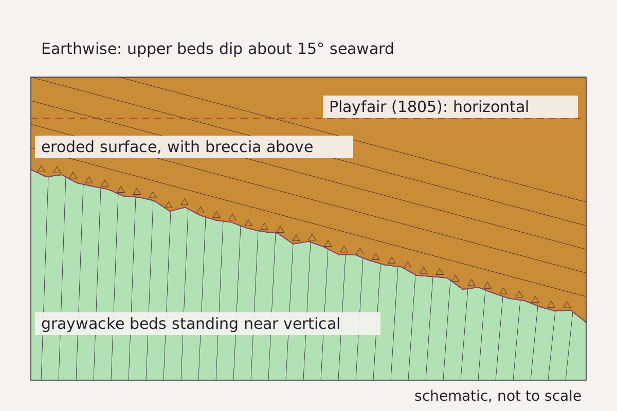
The Siccar Point contact as a schematic section: near-vertical graywacke below, an eroded surface with breccia, and red sandstone above, drawn at the Earthwise dip with Playfair’s horizontal shown as a dashed line.
Benchmark Schematic, not to scale; dips from Earthwise and Playfair (1805), both shown.
"Siccar Point unconformity, schematic section" by Meridian & Moraine, https://meridianandmoraine.com/strata/siccar-point/, licensed under CC BY 4.0 (https://creativecommons.org/licenses/by/4.0/).
Data: Dip and unit names from B. R. Turner and C. T. Scrutton, Geology of Siccar Point and Pease Bay – an excursion, BGS Earthwise (facts only), retrieved 2026-11-15; Horizontal upper beds from John Playfair, Transactions of the Royal Society of Edinburgh vol. 5 (1805), p. 72, public domain
An unconformity is a surface where part of the rock record is missing. The missing rock was worn away, never laid down, or both. An angular unconformity adds one more clue: the layers below sit at an angle to the layers above. At Siccar Point that angle is close to a right angle, which is why this contact makes such a clear first lesson.
Meridian & Moraine starts a reading of rock layers by finding the gap. On an outcrop, a contact like this one is often the first line worth tracing, before any single layer. How much time the gap holds, and whether it was erased or never written, is a separate question that needs dated rocks and published work.
What Hutton saw from the boat
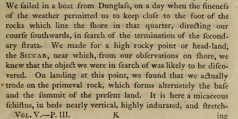
Part of page 71 of John Playfair’s 1805 account of Hutton’s life, where the boat leaves Dunglass and the party lands on beds “nearly vertical.”
"Page 71, from Biographical Account of the Late Dr James Hutton" by John Playfair — https://archive.org/details/transactionsofro05murr/page/n488 — Public domain (US: first published 1805; EU: author died 1819, more than 70 years ago); modified: cropped
James Hutton spent part of the summer of 1788 searching for the place where the steep, hardened rocks of the Lammermuir Hills meet the flatter sedimentary beds along the coast of southeastern Scotland. In the first volume of his Theory of the Earth (1795), Hutton writes that he and Professor John Playfair went to Dunglass “about the beginning of June” to visit Sir James Hall. Because that stretch of coast could only be followed by sea, the three men took a boat south along the shore.
Playfair described the expedition in 1805, in a biography written after Hutton died in 1797. “We sailed in a boat from Dunglass,” he wrote, keeping close to the foot of the cliffs and heading for “a high rocky point or head-land, the Siccar” (p. 71). On landing, the rock beneath them was “a micaceous schistus, in beds nearly vertical, highly indurated” (p. 71). Hutton’s own description is shorter, calling the place “a beautiful picture of this junction washed bare by the sea.”
The BGS Earthwise excursion guide uses the modern names. The lower beds are Silurian graywackes, a hard and gritty kind of sandstone, and the guide describes them as near-vertical. The beds above are breccia and sandstone of the Upper Old Red Sandstone. Earthwise credits the find to Hutton, in the company of Hall and Playfair, and notes that Hutton had already seen other unconformities on Arran and at Jedburgh.
Page 71 tells the trip in order. Its first lines finish the story of Jedburgh. The paragraph that begins “In 1788” then explains why the party went to sea: the coast offered a cross-section through the hills.
The passage shown above, from the foot of the page, covers the landing itself. Playfair writes that the rock at the point “forms alternately the base and the summit of the present land,” a phrase that already holds Hutton’s idea of rock being raised, worn down and buried again. There the party found one set of beds standing on end, with a second set resting on their eroded edges.
Reading one surface as four events
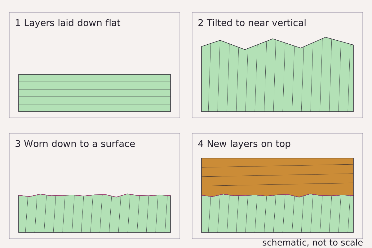
One contact, four events: layers laid down flat, tilted to near vertical, worn down to a surface, then covered by new layers.
Benchmark Schematic, not to scale; sequence from the Earthwise excursion guide and Hutton (1795).
"Four events at the Siccar Point unconformity" by Meridian & Moraine, https://meridianandmoraine.com/strata/siccar-point/, licensed under CC BY 4.0 (https://creativecommons.org/licenses/by/4.0/).
Data: Sequence from B. R. Turner and C. T. Scrutton, Geology of Siccar Point and Pease Bay – an excursion, BGS Earthwise (facts only), retrieved 2026-11-15, and James Hutton, Theory of the Earth vol. 1 (1795), public domain
A single surface at Siccar Point records at least four events. Their order can be read from the rock itself, and the Earthwise guide gives the details for each step.
- Layers laid down flat. The graywackes formed on the sea floor. Earthwise describes them as turbidites, beds dropped by underwater flows of muddy sand, along the edge of the old Iapetus Ocean. Graptolite fossils in the shales give an upper Llandovery age, which places them in the Silurian.
- Tilted to near vertical. When that ocean closed, late in the Silurian, the beds were folded and faulted. At Siccar Point they now dip steeply, so the old sea-floor layers stand almost on end.
- Worn down to a surface. Uplift turned the area into land, and erosion planed the tilted beds down. The cut-off tops of the graywacke mark this step.
- New layers on top. Rivers then spread gravel and sand over the worn surface, in a semi-arid climate, according to Earthwise. The basal breccia is made mostly of angular pieces of the graywacke below.
Read the contact as a page of rock manuscript that was turned on its side, partly erased, and then written over. The erosion in step 3 removed the tops of the tilted beds, and the sandstone in step 4 was laid on what was left. The breccia is the evidence for that link, because most of its broken pieces came from the rock directly underneath.
Step 2 needs a word of care. The four panels show the tilting as a single event, but the rocks only demonstrate that it happened after step 1 and before step 3, not how long it took or whether it came in several pulses.
Another check shows which side of each graywacke bed was originally on top. Earthwise describes the sandstones as normally graded, coarse at the base and finer upward, and notes that the younging direction of the stacked beds can be readily established. In this area, the guide reports, the steep beds become younger toward the northwest.
How much time does the gap hold?
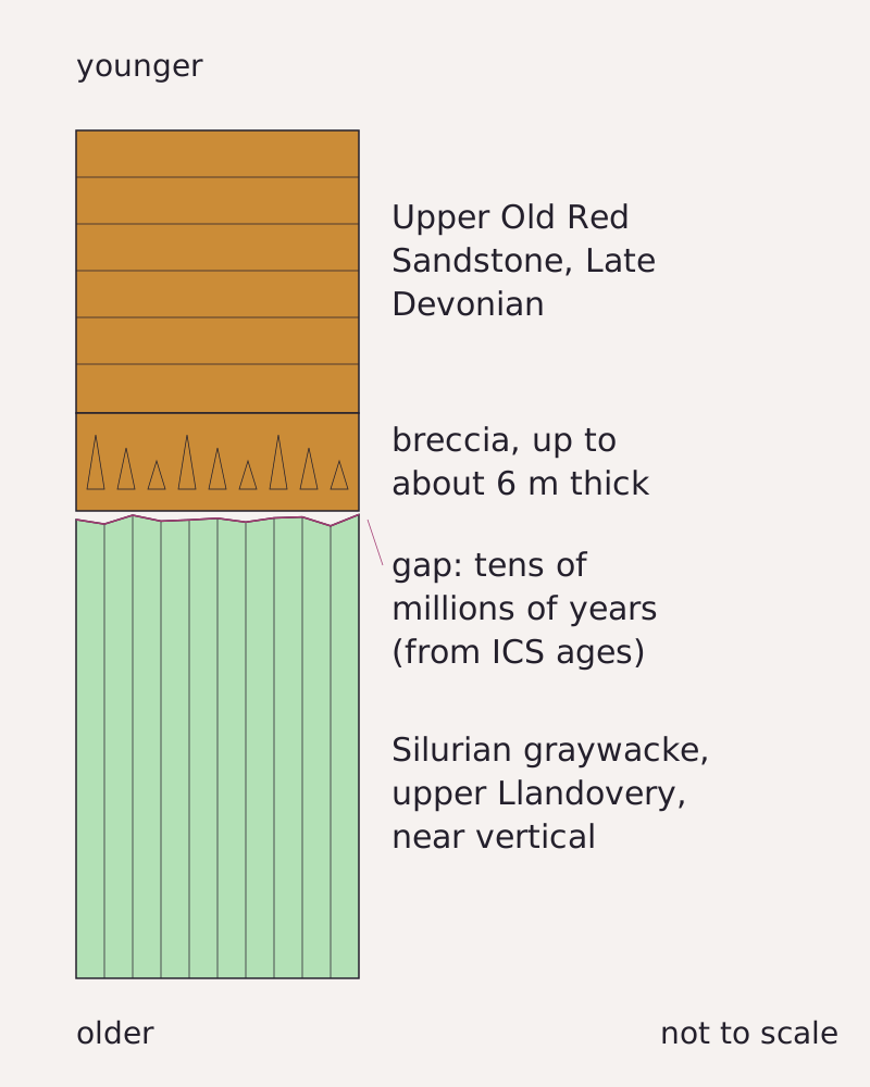
The rocks at Siccar Point as a column, oldest at the bottom: Silurian graywacke, the eroded surface, breccia up to about 6 m thick, and Late Devonian red sandstone above.
Benchmark Schematic, not to scale; units, thickness and the age names taken from this page’s CSV.
"Siccar Point rock column with the time gap" by Meridian & Moraine, https://meridianandmoraine.com/strata/siccar-point/, licensed under CC BY 4.0 (https://creativecommons.org/licenses/by/4.0/).
Data: Units, period names and breccia thickness from B. R. Turner and C. T. Scrutton, Geology of Siccar Point and Pease Bay – an excursion, BGS Earthwise (facts only), retrieved 2026-11-15
The size of the gap is read from the ages of the rocks on either side of it. According to the Earthwise excursion guide, graptolite fossils date the graywackes below the contact to the upper Llandovery, part of the Silurian Period. The same guide describes the red beds above as Upper Old Red Sandstone, laid down as Upper Devonian river deposits, and notes that some of the local Old Red Sandstone could be early Carboniferous.
The International Commission on Stratigraphy’s chart (version 2024/12, unchanged on these points in 2026/06) gives the boundary ages. The Llandovery ends at 432.9 ± 1.2 million years ago, and the Late Devonian runs from 382.31 ± 1.36 to 358.86 ± 0.19 million years ago. Those are ages for the time units, not dates measured on the rocks at Siccar Point.
Set side by side, the two time units leave a gap of tens of millions of years between the youngest graywacke and the red sandstone. Because both ages are known only to the time unit, this page gives a range in words instead of a single figure.
The two old accounts and the modern guide also disagree on the upper beds. Playfair called the red sandstone “horizontal” (p. 72). Earthwise describes it dipping gently seaward at about 15°. Both readings appear in the table, one claim per row.
| Unit | What the source records | Source |
|---|---|---|
| Lower beds | “beds nearly vertical” | Playfair 1805, p. 71 |
| Lower beds | Near-vertical Silurian graywacke, upper Llandovery | Earthwise |
| Upper beds | “red horizontal sandstone” | Playfair 1805, p. 72 |
| Upper beds | Dipping gently seaward at about 15° | Earthwise |
| Upper beds | Upper Devonian red beds | Earthwise |
| Basal breccia | Up to about 6 m thick | Earthwise |
| End of the Llandovery | 432.9 ± 1.2 million years ago | ICS chart 2024/12 |
| Late Devonian | 382.31 ± 1.36 to 358.86 ± 0.19 million years ago | ICS chart 2024/12 |
| The gap | Tens of millions of years | This page’s reading of Earthwise ages against ICS chart 2024/12 |
Download the Siccar Point units table (CSV) (about this file) Data: B. R. Turner and C. T. Scrutton, Geology of Siccar Point and Pease Bay – an excursion, BGS Earthwise (facts only), retrieved 2026-11-15; John Playfair, Transactions of the Royal Society of Edinburgh vol. 5 (1805), pp. 71–72, public domain; International Commission on Stratigraphy, International Chronostratigraphic Chart v2024/12, single boundary ages only, retrieved 2026-11-16
Worn away, or never laid down?
A gap of this kind is not automatically a record of erosion alone, because some unconformities mark long intervals when no sediment accumulated at all. At Siccar Point the truncated bed tops and the breccia made of graywacke fragments show that erosion removed rock, but the contact cannot separate how much of the missing time was spent wearing rock away and how much passed with nothing being deposited.
That limit matters for any number placed on the gap. Any estimate depends on the ages assigned to the youngest graywacke below and the lowest sandstone above. Both can change as dating improves, which is why the table keeps each claim beside its source, so that a later estimate can be added as a new row instead of silently replacing the old one.
The abyss of time: Playfair’s account
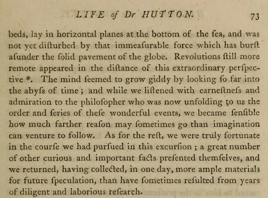
The top of page 73 of John Playfair’s 1805 account of Hutton’s life, with the line about “the abyss of time.”
"Page 73, from Biographical Account of the Late Dr James Hutton" by John Playfair — https://archive.org/details/transactionsofro05murr/page/n490 — Public domain (US: first published 1805; EU: author died 1819, more than 70 years ago); modified: cropped
John Playfair published his account of the trip in 1805, in a long biography of Hutton printed by the Royal Society of Edinburgh. The quotations here follow the printed pages, with the old long s written as a modern s.
Playfair describes the contact itself on page 72. The graywacke “has a thin covering of red horizontal sandstone laid over it,” and the waves have left the junction “not only visible, but … curiously dissected and laid open by the action of the waves.” He adds that “the rugged tops of the schistus are seen penetrating into the horizontal beds of sandstone.”
Then he describes what the three men took from it. “We felt ourselves necessarily carried back to the time when the schistus … was yet at the bottom of the sea” (p. 72), meaning the very rock under their feet. An older stage followed in thought, when even those upright rocks “lay in horizontal planes at the bottom of the sea” (p. 73). Playfair’s best-known line comes next, on page 73: “The mind seemed to grow giddy by looking so far into the abyss of time.”
The same page closes the scene with a remark about reasoning itself: listening to Hutton explain the order of events, Playfair wrote, “we became sensible how much farther reason may sometimes go than imagination can venture to follow” (p. 73). The argument rested on the arrangement of the rocks, not on any measurement of time.
Playfair’s sequence matches the four events read from the rock today: deposition on a sea floor, tilting, a worn surface, and new sediment on top. His account gives no number of years for any of these steps, which is why the ages in the previous section come from a modern time scale.
Jedburgh: Hutton’s other unconformity
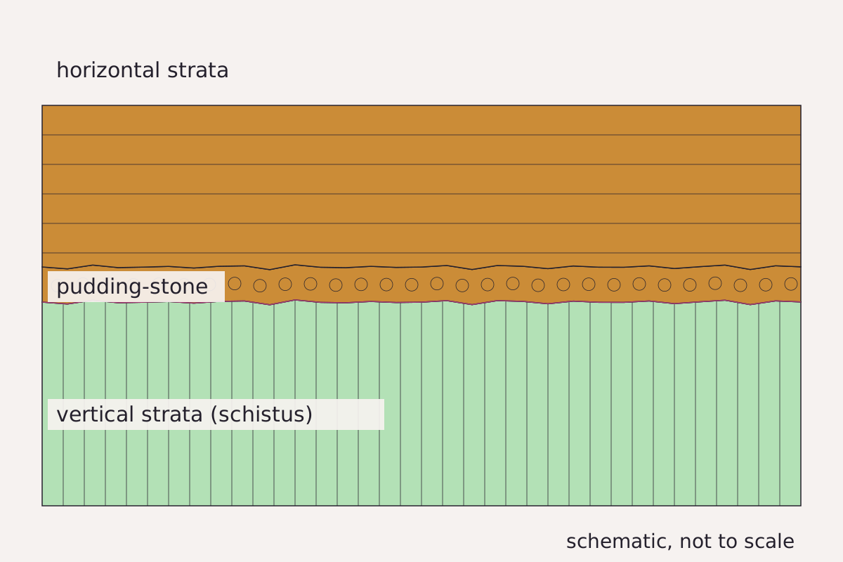
The Jedburgh junction as Hutton described it in 1795: vertical strata in the riverbed, a pudding-stone layer on their cut-off ends, and horizontal strata above.
Benchmark Schematic, not to scale; drawn from the description in Hutton (1795), not from his plate.
"Jedburgh junction, schematic from Hutton’s description" by Meridian & Moraine, https://meridianandmoraine.com/strata/siccar-point/, licensed under CC BY 4.0 (https://creativecommons.org/licenses/by/4.0/).
Data: Arrangement from James Hutton, Theory of the Earth vol. 1 (1795), public domain
Siccar Point was not Hutton’s first look at this kind of contact. Earthwise dates his Jedburgh visit to 1787. In the 1795 Theory of the Earth, Hutton recalls walking in the valley above the town of Jedburgh, where he “was surprised with the appearance of vertical strata in the bed of the river, where I was certain that the banks were composed of horizontal strata.”
Hutton also noticed a third layer between the two. He calls it a pudding-stone, a rock of rounded stones and gravel, “interposed between the two, lying immediately upon the one and under the other.” The stones in it, he wrote, came from the vertical strata below and were “worn and rounded by attrition.”
From that, Hutton reasoned that the lower beds had been worn down before the upper beds formed. In his words, “It is much more probable to suppose, that the sea had washed away the relics of the broken and disordered strata, before those that are now superincumbent had been begun to be deposited.” Hutton’s 1795 volume included a copper plate of the Jedburgh spot. The figure above follows his text instead of that plate.
When the 1788 boat trip reached Siccar Point, Hutton was looking for the same pattern on the coast. Playfair’s page 71 even sets the two places side by side. At Jedburgh he records “red sandstone, in beds nearly horizontal,” over schistus “in vertical plates,” with a breccia between them.
Where to see it safely
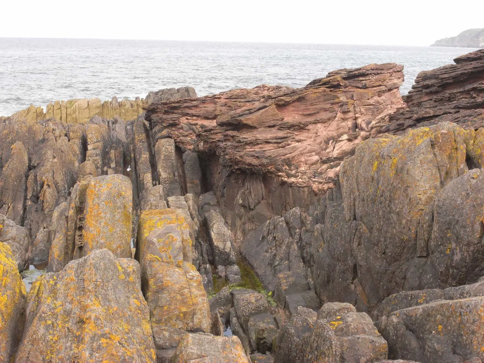
Upright gray graywacke beds in the foreground, with red sandstone lying across them at a low angle behind and the sea beyond, at Siccar Point.
"Hutton’s Unconformity at Siccar Point, Scotland" by Lysippos — https://commons.wikimedia.org/wiki/File:Hutton%27s_unconformity_siccar_point.JPG — CC BY 3.0 (https://creativecommons.org/licenses/by/3.0/); modified: resized
The Earthwise guide describes cliffs up to 70 m high on this stretch of coast. It also states that the unconformity can be seen clearly from the cliff top, which gives a good view of the rocks to the north. For this contact, the reading altitude is that cliff-top viewpoint: high enough to see the upright beds and the red cover together, and well back from the shore.
From the same viewpoint, according to Earthwise, the coast to the northwest shows dark gray, folded and vertical Silurian graywackes followed by brightly colored Old Red Sandstone, which grades upward into the duller Lower Carboniferous rocks of Pease Bay. From up there, the view takes in more of the sequence than the contact alone.
The site is protected, and Earthwise notes that hammering is not allowed. The guide’s access notes were compiled in 2006, and they advise visitors to check current access arrangements before a trip. Meridian & Moraine describes the view from the cliff top only, from a safe distance back from the edge.
The same contact can be read from a photograph. In the picture above, look at the gray beds in the foreground: their layering runs up and down. Then trace them upward to where the red rock begins, and notice that the red layers run across them at a low angle instead of continuing their direction.
Siccar Point is one of several places to practice that reading. Lulworth Crumple shows layers squeezed into folds on a sea cliff, and columnar basalt shows a coastal rock face that cracked into columns as it cooled. A Benchmarks page explains how sources and schematic figures are handled across the site.
Next time a road cut, quarry face or sea cliff shows two sets of layers, find a safe pull-off or viewpoint at a distance, then start with the line between them. Follow the lower layers up to where they stop, then check whether the layers above run parallel to them or cut across them at an angle.
Next overpass
- How to read a geologic map: lay this rock face down flat, and the contact becomes a line where two colors meet.
- Richat Structure: from orbit, another set of rock layers worn down flat, this time a dome in the Sahara.
Sources
- Brian Turner and Colin Scrutton, “Geology of Siccar Point and Pease Bay – an excursion,” BGS Earthwise, from Colin Scrutton (ed.), Northumbrian Rocks and Landscape: A Field Guide, 2nd ed. (Yorkshire Geological Society, 2004); page revision of 11 May 2020. earthwise.bgs.ac.uk/index.phpRead: full page (Siccar Point locality and geological background)
- John Playfair, “Biographical Account of the Late Dr James Hutton, F.R.S. Edin.,” Transactions of the Royal Society of Edinburgh 5, part 3 (History of the Society) (1805). archive.org/details/transactionsofro05murr/pa…Read: pages 70–73, checked against the page images
- James Hutton, Theory of the Earth, with Proofs and Illustrations, vol. 1 (Edinburgh, 1795). www.gutenberg.org/ebooks/12861Read: chapter on the junction of the schistus with the horizontal strata (Jedburgh and Siccar Point passages), transcribed text
- International Commission on Stratigraphy, International Chronostratigraphic Chart, version 2024/12. stratigraphy.org/ICSchart/ChronostratChart2024-12.…Read: full chart (Silurian, Devonian, Paleogene and Neogene boundary ages used); change log checked for later versions
Cite this page
The Reading Room. “Siccar Point: Hutton’s Lower Beds Stand Almost on End.” Meridian & Moraine, published 16 November 2026. https://meridianandmoraine.com/strata/siccar-point/. Accessed on the date you read it.
How readings are checkedAll correctionsReport an error on this page (contact@meridianandmoraine.com)
More from Reading Rock Layers
Reading Rock Layers
Lulworth Crumple: The Limestone Cracked, the Mudstone Flowed
Image credit
"West end of Stair Hole, Lulworth, Dorset, England" by Adrian Pingstone — https://commons.wikimedia.org/wiki/File:West_end_of_Stair_Hole,_Dorset,_England_arp.jpg — Public domain (US and EU: released into the public domain worldwide by the photographer, Adrian Pingstone, as stated on the Commons file page); modified: cropped, resized
Reading Rock Layers
How to Read a Geologic Map: A Contact Bends With the Land
Image credit
"A Delineation of the Strata of England and Wales, with part of Scotland (detail)" by William Smith (1769–1839); British Library — https://commons.wikimedia.org/wiki/File:Geological_map_-_William_Smith,_1815_-_BL.jpg — CC0 1.0 (https://creativecommons.org/publicdomain/zero/1.0/); modified: cropped
Reading Rock Layers
Columnar Basalt: Not Every Causeway Column Is a Hexagon
Image credit
"Giant's Causeway, County Antrim, Ireland, photochrom published by the Detroit Publishing Co. under license from Photoglob Zürich" by Unknown author — https://commons.wikimedia.org/wiki/File:Giant%27s_Causeway,_County_Antrim,_Ireland,_1890s.jpg — Public domain (US: published before 1931 (photochrom printed between 1890 and 1900); EU: anonymous work, photographer not named, first published more than 70 years ago); modified: cropped, resized