Richat Structure: A Worn-Down Dome, Not an Impact Crater
The Reading Room Published
Short answer
The Richat Structure in Mauritania is a worn-down dome, not an impact crater, according to a 2024 study. Erosion planed the dome flat, so its rock layers now circle the center as rings.
Viewing card
- Where
- 21.124°N 11.402°W (image frame center); frame 66 × 43.9 km; Taoudenni basin, Mauritania (per Abdeina et al. 2024)
- Seen from
- Sentinel-2A MSI, bands 4-3-2 (true color)
- Captured
- 2024-01-26 11:25 UTC · sentinel-2-c1-l2a, baseline 05.10
- Reading altitude
- 41.25 m pixels; frame 66 × 43.9 km; outermost rings about 40 km across (literature value, USGS EROS and Abdeina et al. 2024), about 970 pixels at this pixel size
- Written by
- Rock layers lifted into a dome above an igneous intrusion, then planed flat by erosion so the layers crop out as rings (per Abdeina et al. 2024)
This card as data (CSV) About this file
Data: Facts from E.H. Abdeina et al., LITHOS 482-483 (2024) 107698, CC BY 4.0, https://doi.org/10.1016/j.lithos.2024.107698; Contains modified Copernicus Sentinel data 2024
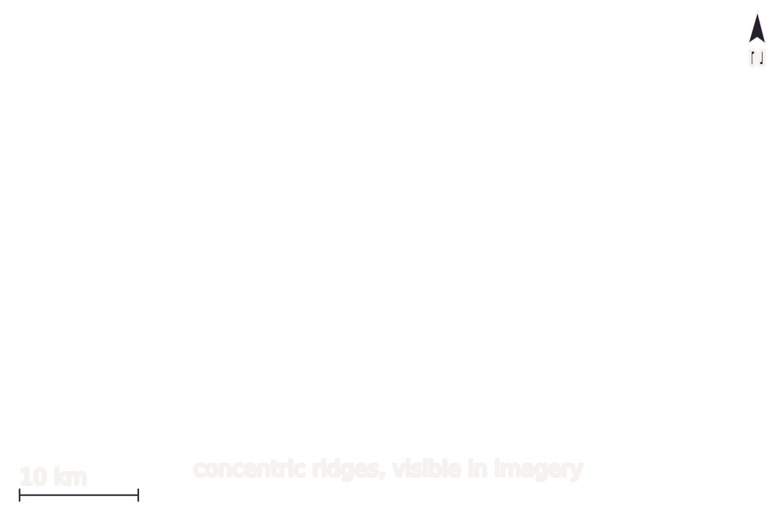
Open the image full size · annotation layer (SVG)
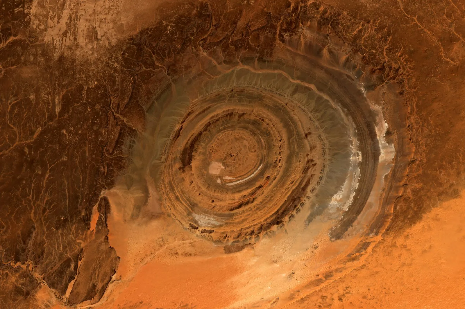
The Richat Structure on 26 January 2024, in Sentinel-2 true color. Rings of dark ridges and pale ground circle one center, visible in imagery, and pale orange ground hides the outer rings to the south and southeast. North is up, with the image grid about 0.9° off true north; the frame is 66 km wide and 43.9 km tall.
Benchmark Sentinel-2 L2A scene S2A_T29QKD_20240126T111440_L2A (sentinel-2-c1-l2a, baseline 05.10); bands 4-3-2 with one stretch 0.0584–0.5333, gamma 1; 41.25 m pixels, not enlarged; scale bar within 0.03% of the geodesic distance between its ends; north arrow at true north for the frame center.
Image
"Richat Structure, Adrar, Mauritania true-color composite, Sentinel-2 L2A scene S2A_T29QKD_20240126T111440_L2A via Earth Search (Element 84)" by Meridian & Moraine — https://earth-search.aws.element84.com/v1/collections/sentinel-2-c1-l2a/items/S2A_T29QKD_20240126T111440_L2A — Copernicus Sentinel data legal notice (https://sentinels.copernicus.eu/documents/247904/690755/Sentinel_Data_Legal_Notice); modified: cropped, resampled, color-stretched; rights notice: Contains modified Copernicus Sentinel data 2024
Annotation layer
"Annotation layer for Richat Structure, Adrar, Mauritania (2024)" by Meridian & Moraine, https://meridianandmoraine.com/satellite/richat-structure/, licensed under CC BY 4.0 (https://creativecommons.org/licenses/by/4.0/).
In the Mauritanian desert, rings of ridges circle one center like a target seen from far above. The Richat Structure looks like a crater, yet the target is the worn stump of a dome pushed up from below. A 2024 paper in the journal Lithos by El Houssein Abdeina and colleagues, published under a CC BY 4.0 license, calls it “an eroded dome, 40 km in diameter.” The United States Geological Survey's EROS Center gives its outermost rings as approximately 40 km (25 miles) across.
The image on its own shows only shape, color and position. Calling the rings a dome crosses the ground-truth gap only because published sources describe the same place, the same landform and the same claim. The same rule holds for the dark surfaces of an alluvial fan in Death Valley, where a survey, not the picture, names each surface.
What is the Richat Structure?
Abdeina and colleagues place the structure in the Taoudenni sedimentary basin of Mauritania. Its rings are crests of hard sandstone and quartz-rich sandstone, of Late Proterozoic to Lower Paleozoic age, with softer mudstones between them. Two bodies of gabbro, a dark rock that cooled from magma, form two of the innermost rings. A breccia of broken rock, 3 km across and up to 40 m thick, fills the center.
The 2024 paper reads the history in three steps. First, gabbro magma spread between the sedimentary layers as two flat sheets called sills. Modeling of new argon dates suggests a time between 230 and 200 million years ago, although the authors write that “no robust age was obtained.”
About 100 million years later, an alkaline intrusion, seen at the surface today as carbonatite dikes, lifted the gabbros and their host rocks into a dome. The 2024 abstract calls the result “a circular doming, 40 km in diameter,” and says that “the subsequent erosion led to the actual flattened concentric structure.”
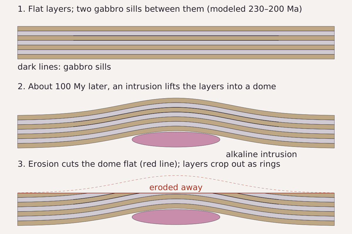
How flat layers become rings, in the sequence Abdeina et al. (2024) argue for: gabbro sills (modeled at 230–200 Ma, with no robust age), a dome lifted over an intrusion about 100 million years later, then erosion. The sills crop out as rings with the rest of the pile.
Benchmark Schematic, not to scale; sequence and ages from Abdeina et al. (2024); layer thicknesses and dome height not drawn to any measurement.
"Richat Structure in three steps: sills, doming, erosion (schematic)" by Meridian & Moraine, https://meridianandmoraine.com/satellite/richat-structure/, licensed under CC BY 4.0 (https://creativecommons.org/licenses/by/4.0/).
Data: Sequence and ages from E.H. Abdeina, F. Jourdan, G. Chazot, H. Bertrand, B. Le Gall, How old is the Eye of Africa? A polyphase history for the igneous Richat Structure, Mauritania, LITHOS 482-483 (2024) 107698, CC BY 4.0, https://doi.org/10.1016/j.lithos.2024.107698
Read as handwriting, the rings are a manuscript page whose top lines were erased. When a dome of stacked layers is cut flat, each layer meets the new surface along a closed loop around the center. The USGS page adds that persistent northeasterly winds keep much of the dome free from sand, which leaves those layers exposed.
Not every reader of these rocks agrees on the gabbros' shape. The 2024 paper notes that some earlier work treated them as sills and some as ring dikes, steep circular walls of magma, and it argues for sills. It also notes that sand cover prevents clear views of the contacts that would settle the question. Gabbro is cooled magma, like the lava that cracked into columnar basalt beside the sea.
Why isn't it an impact crater?
A crater-like target invites the impact idea, and the idea was proposed. Abdeina and colleagues credit the meteorite-impact model to a 1964 study by Cailleux and colleagues and write that the structure was “formerly hypothesized as an astrobleme.” They add that the impact hypothesis “has long been ruled out in favour of a magmatic origin,” citing a 1969 paper by Dietz, Fudali and Cassidy whose title ends “not astroblemes.”
The USGS EROS page says the same in plain terms. The feature “was initially interpreted to be an asteroid impact structure, but most scientists have now concluded that it was caused by geologic uplift.”
What the 2024 paper lists instead is a set of rock bodies: two ring-like gabbro bodies, the central breccia and more than 60 carbonatite dikes, most of them in the southern half. Its abstract groups all three under “a complex igneous intrusion.” Kimberlite rocks were also described from a trench in the north, and they are no longer exposed at the surface.
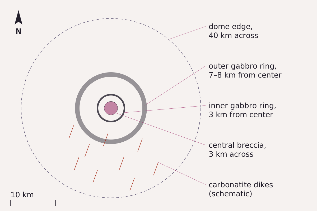
The rocks at the heart of the dome as Abdeina et al. (2024) describe them: a breccia 3 km across, a thin gabbro ring 3 km from the center and another 7 to 8 km out, inside a dome 40 km across. Short red strokes mark carbonatite dikes, mostly in the south.
Benchmark Schematic plan; rings drawn as circles at the distances stated by Abdeina et al. (2024); ring widths exaggerated so they show; dike positions schematic.
"Rock bodies of the Richat Structure at their stated distances (schematic plan)" by Meridian & Moraine, https://meridianandmoraine.com/satellite/richat-structure/, licensed under CC BY 4.0 (https://creativecommons.org/licenses/by/4.0/).
Data: Distances and sizes from E.H. Abdeina, F. Jourdan, G. Chazot, H. Bertrand, B. Le Gall, How old is the Eye of Africa? A polyphase history for the igneous Richat Structure, Mauritania, LITHOS 482-483 (2024) 107698, CC BY 4.0, https://doi.org/10.1016/j.lithos.2024.107698
The breccia at the center has a separate story. The 2024 paper reports that one earlier study traced it to collapse after hot water dissolved limestone layers, and calls its link to the igneous events still unclear. The sources read for this page do not describe the mineral tests behind the 1969 verdict, so this page does not list them. Popular online claims also link the rings to Atlantis; none of the sources read for this page mentions that idea.
How big is the Eye of the Sahara?
Both sources give the same round number. Abdeina et al. (2024) describe a dome 40 km in diameter, and USGS EROS gives the outermost rings as approximately 40 km across. In the Sentinel-2 image at the top, with 41.25 m pixels, that shared figure spans about 970 pixels, roughly three-fifths of the 66 km frame width.
The rings were not measured on this page's image, and the image itself shows why a single edge is hard to draw. To the south and southeast, pale orange ground hides the outer rings, while to the north and east they stay sharp, all visible in imagery. The 40 km from USGS EROS and Abdeina et al. in the table and the CSV is a literature value, marked as one.
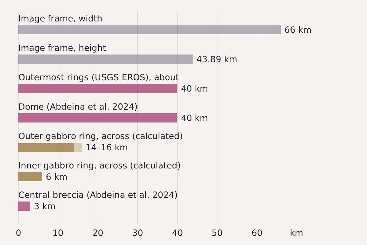
Sizes from this page's CSV: the image frame, the 40 km dome and outer rings from Abdeina et al. (2024) and USGS EROS, and the inner rings and breccia from the same 2024 paper.
Benchmark Each bar drawn from this page's CSV; sources and methods in the table; ring diameters are twice the stated distance from the center.
"Richat Structure sizes against the image frame" by Meridian & Moraine, https://meridianandmoraine.com/satellite/richat-structure/, licensed under CC BY 4.0 (https://creativecommons.org/licenses/by/4.0/).
Data: Sizes from E.H. Abdeina, F. Jourdan, G. Chazot, H. Bertrand, B. Le Gall, How old is the Eye of Africa? A polyphase history for the igneous Richat Structure, Mauritania, LITHOS 482-483 (2024) 107698, CC BY 4.0, https://doi.org/10.1016/j.lithos.2024.107698; Outer ring size from the USGS EROS Center media page Richat Structure, Mauritania (public domain); Frame size from Sentinel-2 L2A scene S2A_T29QKD_20240126T111440_L2A; contains modified Copernicus Sentinel data 2024
| Measurement | Value | Method | Source |
|---|---|---|---|
| Outermost rings, across (approximate) | 40 km | Literature | USGS EROS |
| Dome, diameter | 40 km | Literature | Abdeina et al. 2024 |
| Outer gabbro ring (Tin Jouker), distance from center | 7–8 km | Literature | Abdeina et al. 2024 |
| Outer gabbro ring, across (assumes a circle) | 14–16 km | Twice the stated distance | Abdeina et al. 2024 |
| Inner gabbro ring (Guelb Richat), distance from center | 3 km | Literature | Abdeina et al. 2024 |
| Inner gabbro ring, across (assumes a circle) | 6 km | Twice the stated distance | Abdeina et al. 2024 |
| Central breccia, diameter | 3 km | Literature | Abdeina et al. 2024 |
| Image frame, width × height | 66 × 43.89 km | Scene grid | Sentinel-2 scene metadata |
Download the Richat Structure sizes (CSV) (about this file) Data: Values from E.H. Abdeina, F. Jourdan, G. Chazot, H. Bertrand, B. Le Gall, How old is the Eye of Africa? A polyphase history for the igneous Richat Structure, Mauritania, LITHOS 482-483 (2024) 107698, CC BY 4.0, https://doi.org/10.1016/j.lithos.2024.107698; USGS EROS Center, Richat Structure, Mauritania (media page, public domain); Contains modified Copernicus Sentinel data 2024
Inside the dome, the numbers shrink fast. The 2024 paper gives the inner gabbro ring, Guelb Richat, as 30 m wide and the outer one, Tin Jouker, as about 70 m wide. In this image's 41.25 m pixels, a 30 m ring is narrower than one pixel, so the image alone cannot say which ridge is gabbro.
Next time the Richat Structure turns up in a view from orbit, look for the white patches first. Abdeina and colleagues describe two flat-floored hollows with salt deposits in the center and south of the structure, and white patches sit at the center and just south of it in the image above, visible in imagery. The sources read here are silent on the whiter ground along the eastern rings. Then trace one dark ring from the north, where it stays sharp, around to the south, where pale ground blurs it.
Next overpass
- How to read a geologic map: rings of rock on the ground become rings of color on a geologic map.
- Oxbow lake: another shape read from orbit, this one a loop a river left behind.
Sources
- El Houssein Abdeina, Fred Jourdan, Gilles Chazot, Hervé Bertrand and Bernard Le Gall, "How old is the Eye of Africa? A polyphase history for the igneous Richat Structure, Mauritania," LITHOS 482–483 (2024): 107698. doi.org/10.1016/j.lithos.2024.107698Read: full text (publisher's open-access version): abstract, sections 1–3 and references checkedText license: CC BY 4.0 (terms)
- U.S. Geological Survey, Earth Resources Observation and Science (EROS) Center, "Richat Structure, Mauritania" (media page, about 2008). www.usgs.gov/media/images/richat-structure-mau…Read: full page (detailed description)
- Copernicus Sentinel-2 Level-2A scene S2A_T29QKD_20240126T111440_L2A (collection sentinel-2-c1-l2a, processing baseline 05.10), STAC item via Earth Search by Element 84. earth-search.aws.element84.com/v1/collections/sentinel-2-c1-l2a/…Read: scene metadata
Cite this page
The Reading Room. “Richat Structure: A Worn-Down Dome, Not an Impact Crater.” Meridian & Moraine, published 16 November 2026. https://meridianandmoraine.com/satellite/richat-structure/. Accessed on the date you read it.
How readings are checkedAll correctionsReport an error on this page (contact@meridianandmoraine.com)
More from Read from Orbit
Read from Orbit
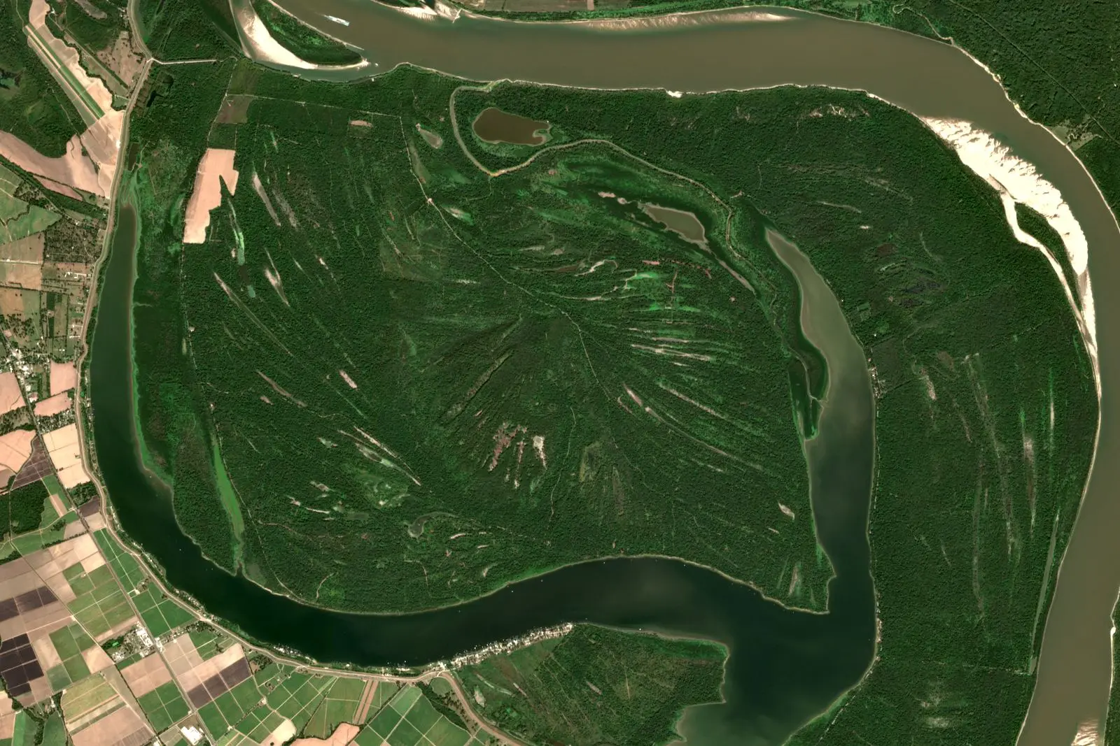
Oxbow Lake: A River Gets Shorter by Bending Too Far
Image credit
"Raccourci Lake (Old River), Louisiana true-color composite, Sentinel-2 L2A scene S2A_T15RXQ_20241021T165322_L2A via Earth Search (Element 84)" by Meridian & Moraine — https://earth-search.aws.element84.com/v1/collections/sentinel-2-c1-l2a/items/S2A_T15RXQ_20241021T165322_L2A — Copernicus Sentinel data legal notice (https://sentinels.copernicus.eu/documents/247904/690755/Sentinel_Data_Legal_Notice); modified: cropped, resampled, color-stretched; rights notice: Contains modified Copernicus Sentinel data 2024
Read from Orbit
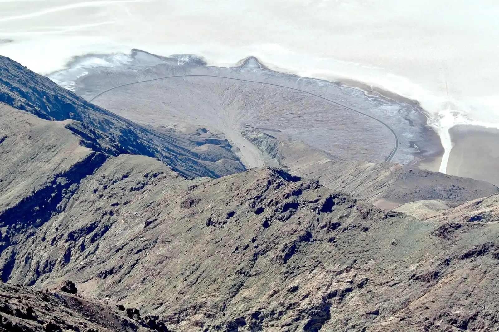
Alluvial Fan: In Death Valley, Dark Is Older, Up to a Point
Image credit
"Death Valley Alluvial Fan from Dante's View" by Wilson44691 — https://commons.wikimedia.org/wiki/File:Death_Valley_Alluvial_Fan_from_Dante%27s_View.JPG — CC0 1.0 (https://creativecommons.org/publicdomain/zero/1.0/); modified: cropped, resized
 Illustration
Read from Orbit
Atmospheric River: Moving Water Vapor, Not a River of Cloud
Image credit (illustration)
Illustration: Meridian & Moraine. Generated illustration — not a photograph, satellite image or map; not to scale. Reuse: CC BY 4.0 (https://creativecommons.org/licenses/by/4.0/) to the extent any rights apply.