Lenticular Clouds: Most Mark the Crest of a Mountain Wave
The Reading Room Published
Short answer
Lenticular clouds are smooth, lens-shaped clouds that usually form where air rises in a mountain wave and sit on the wave crests. They remain nearly stationary over the ground while air moves through them.
Viewing card
- Where
- Over a mountain ridge or on its downwind side, sometimes several lenses in a row farther downwind; a missing mountain does not rule one out
- Seen from
- The ground, facing the ridge and the sky on its downwind side
- Captured
- Comparison photo: NWS Historic Collection image wea00046 by Ralph F. Kresge, no date on the file page; all other figures are schematic, not to scale
- Reading altitude
- In the sky: the ridge, the sky above it and the sky on its downwind side, from the horizon up to well past 30° above the horizon
- Written by
- Air crossing the ridge rises and sinks in waves; where it rises above the level at which it condenses, at a crest, a lens forms and holds its place while the air passes through it (NWS)
This card as data (CSV) About this file
Data: Sources named in the card: AMS Glossary of Meteorology (mountain wave, mountain-wave cloud, lenticularis, standing cloud, crest cloud), retrieved 2026-11-16; NWS Observing Handbook No. 1 (2010)
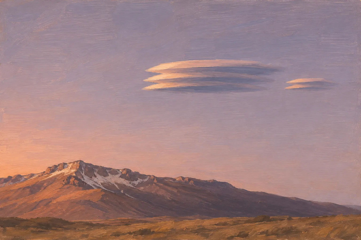
Lens-shaped clouds hang downwind of a ridge, on the crests of the wave the mountain sets in the airflow. Illustration, not to scale.
Illustration: Meridian & Moraine. Generated illustration — not a photograph, satellite image or map; not to scale. Reuse: CC BY 4.0 (https://creativecommons.org/licenses/by/4.0/) to the extent any rights apply.
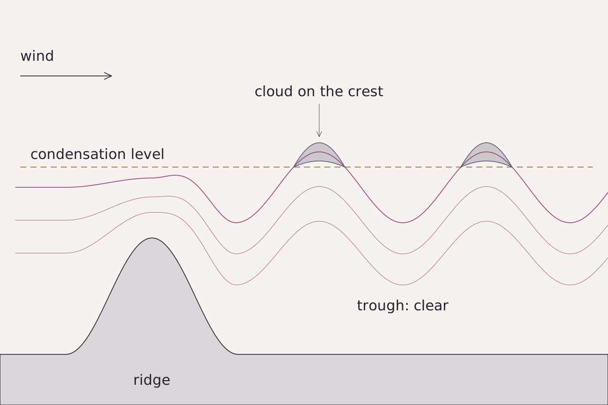
Stable air crosses a ridge and keeps rising and sinking in waves downwind. Cloud appears only where the rising air gets above the level at which it condenses, so the lenses sit on the crests.
Benchmark Schematic, not to scale; cloud drawn only where the airflow line rises above the condensation level, at the wave crests, following the AMS Glossary entry for mountain-wave cloud; no wavelength or height drawn to any value.
"Mountain wave with lens clouds on its crests" by Meridian & Moraine, https://meridianandmoraine.com/aloft/lenticular-clouds/, licensed under CC BY 4.0 (https://creativecommons.org/licenses/by/4.0/).
Data: Definitions from the AMS Glossary of Meteorology (mountain wave, mountain-wave cloud, cap cloud), retrieved 2026-11-16
A smooth cloud shaped like a lens, with sharp edges, sits beside a mountain ridge. The air around it keeps moving, yet the cloud holds its place over the same stretch of ground. It marks a place in the airflow rather than a body of air carried along by the wind. The American Meteorological Society's Glossary of Meteorology puts that place on the crests of mountain waves.
Where do lenticular clouds form?
In the AMS Glossary, a mountain wave is a wave formed when stable air flows over a mountain or a mountain barrier. Past the barrier the air rises and sinks in a train of waves. If the incoming air holds enough moisture, the waves make clouds.
The AMS entry for mountain-wave cloud places those clouds: they form in the rising branches of the waves and occupy the crests. The NWS Observing Handbook No. 1 (2010) defines a crest in its glossary, on page 5-2, as the highest part of a wave. Rising air cools, and the AMS entry for cap cloud describes the same step over a single peak, where moist air forced up over the summit cools and condenses.
The glossary describes two kinds of mountain wave. Vertically propagating waves can be many tens of kilometers or more from crest to crest, usually reach up into the lower stratosphere and, in their pure form, lean upwind with height; with enough moisture they produce what the AMS calls altocumulus standing lenticular. Trapped lee waves are shorter, generally 5–35 km from crest to crest, and form a series of waves running parallel to the ridge.
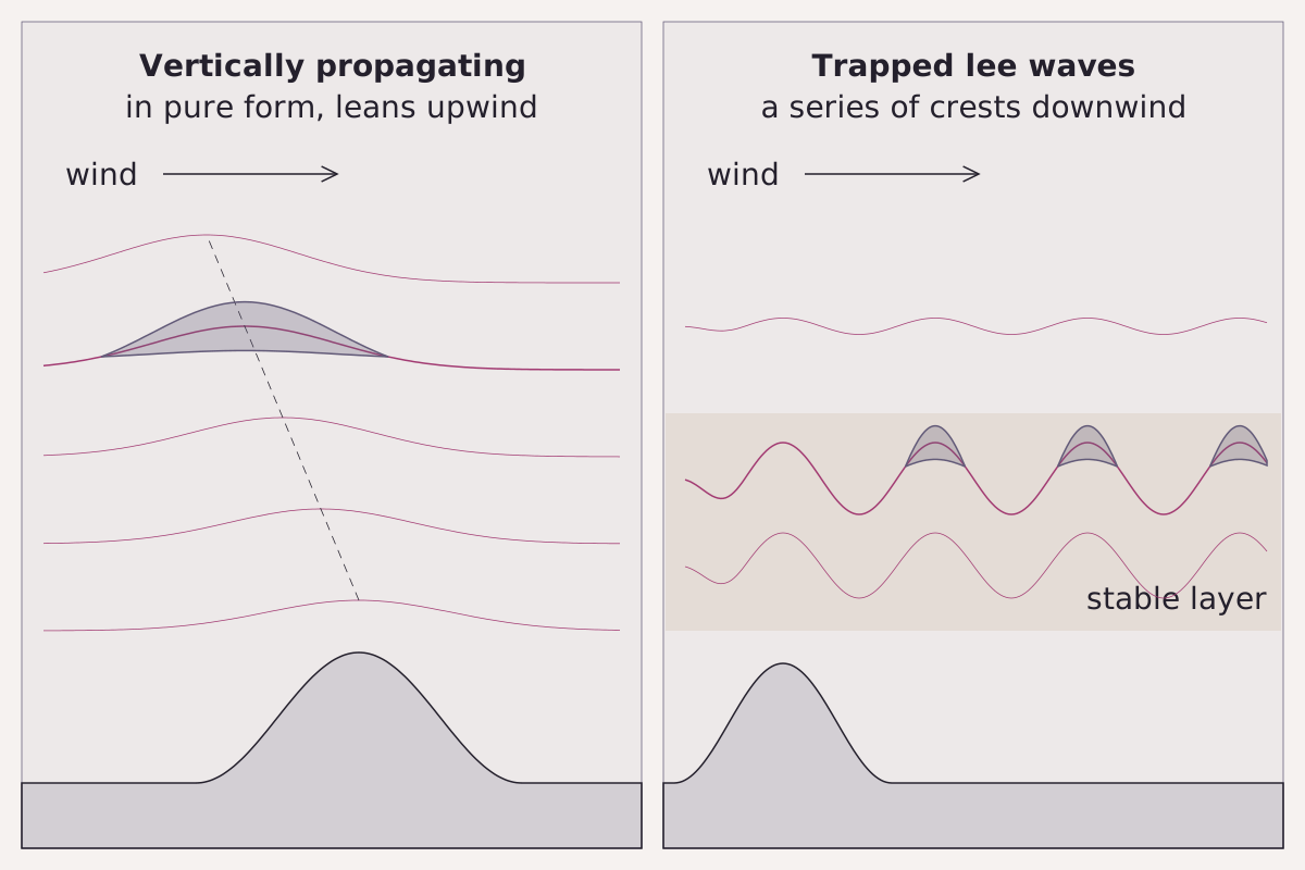
Two kinds of mountain wave described in the AMS Glossary. The first, in its pure form, leans upwind with height; the second repeats downwind in a series of crests, each able to carry its own cloud.
Benchmark Schematic, not to scale; wave forms and cloud positions follow the AMS Glossary entries for mountain wave and mountain-wave cloud; no wavelength drawn to any value.
"Vertically propagating and trapped lee mountain waves" by Meridian & Moraine, https://meridianandmoraine.com/aloft/lenticular-clouds/, licensed under CC BY 4.0 (https://creativecommons.org/licenses/by/4.0/).
Data: Definitions from the AMS Glossary of Meteorology (mountain wave, mountain-wave cloud), retrieved 2026-11-16
The same AMS entry says trapped lee waves can carry cloud bands parallel to the ridge for many wavelengths downstream. From the ground, that can mean several lenses lined up downwind of one range. Seen from orbit, air flowing past an island leaves a different pattern, a trail of swirls called a von Kármán vortex street.
Why does a lenticular cloud hold still in the wind?
The NWS Observing Handbook No. 1 (2010) answers this in its glossary, on page 5-3. It describes a lenticular as “a type of cloud formed in the ascending portion of an airstream, which remains stationary while the air blows through it.” The AMS entry for lenticularis makes the same point in its own terms: when lee waves make these clouds, they hold nearly still relative to the ground beneath them.
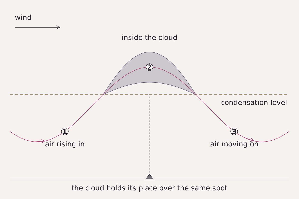
The same air rises into the lens, passes inside it and moves on, while the lens holds its place over one spot on the ground, as the NWS handbook's glossary describes.
Benchmark Schematic, not to scale; airflow passes through a fixed cloud at the wave crest, following the NWS Observing Handbook No. 1 glossary (page 5-3) and the AMS Glossary entry for lenticularis.
"Air moves through a lenticular cloud that holds its place" by Meridian & Moraine, https://meridianandmoraine.com/aloft/lenticular-clouds/, licensed under CC BY 4.0 (https://creativecommons.org/licenses/by/4.0/).
Data: NWS Observing Handbook No. 1 (2010), glossary page 5-3; definition from the AMS Glossary of Meteorology (lenticularis), retrieved 2026-11-16
Read the cloud as a stroke of shorthand that the air rewrites in the same spot, over and over. Moist air rises into the upwind end, where cloud forms, and the same air leaves by the downwind end as it moves on. At any moment the cloud is made of different air from the cloud seen earlier.
The wave holds still because the mountain does. In the AMS definition, a lee wave is a disturbance set up by a barrier in the flow, and for that reason it stays fixed relative to the barrier. The AMS mountain wave entry adds a limit: the waves are often standing or nearly so, but only as far as conditions upstream hold steady. None of the sources read for this page gives a figure for how long one cloud lasts, so none appears here.
What these clouds mean for flying is a question for national weather services and aviation authorities. This page reads only the cloud's shape and place.
Lenticular cloud or ordinary altocumulus?
Lenticular is a species name, not a genus. The AMS entry for lenticularis says the species turns up mainly in three genera: altocumulus, cirrocumulus and, rarely, stratocumulus. Each of those is one of the ten types of clouds, so the first step is to name the genus.
Ordinary altocumulus looks different. The NWS handbook, on page 2-62, describes altocumulus as a white or gray patch, sheet or layer of cloud made of rounded masses or rolls, whose small elements usually look between one and five degrees wide. A lenticular cloud, in the AMS description, is a more or less isolated lens or almond, generally smooth, with sharp outlines.
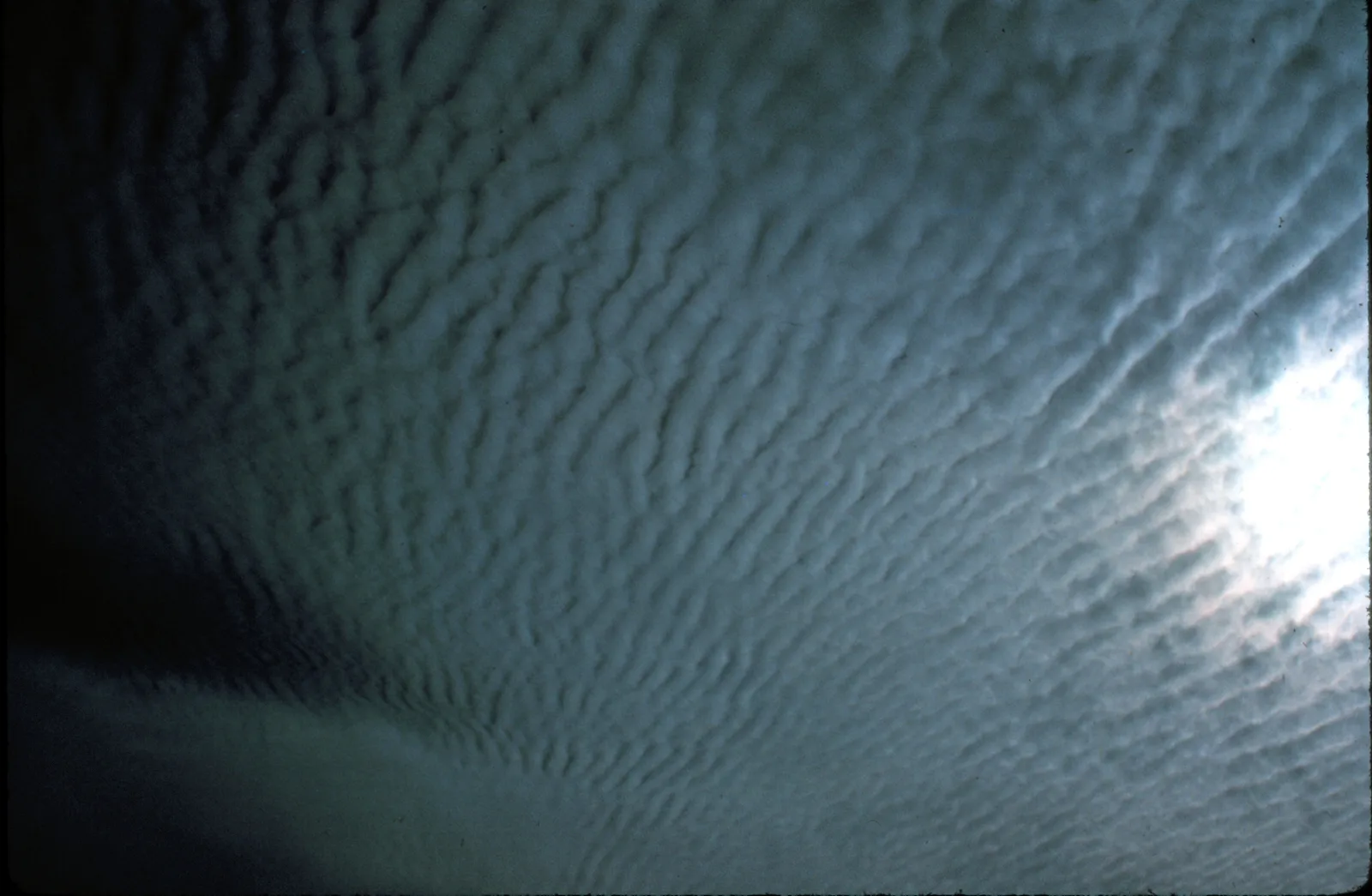
An altocumulus layer from the NWS historic collection, labeled here to genus only. Many small rounded elements fill the frame in rows, and none stands alone as a smooth lens.
"Altocumulus clouds, NOAA Photo Library image wea00046 (Historic NWS Collection)" by Ralph F. Kresge — https://commons.wikimedia.org/wiki/File:Altocumulus_clouds8_-_NOAA.jpg — Public domain (US: U.S. Government work, made by a NOAA employee as part of official duties (17 U.S.C. §105); EU: U.S. Government work with no copyright claimed at source, marked PD-USGov-NOAA on the Commons file page)
The NWS ship code shows how close the two can be. Its code table for middle clouds, on page 2-63, groups almond- or fish-shaped patches of altocumulus under one code figure, and the picture page for that figure, page 2-65, adds altocumulus lenticular to it. In that code, a lenticular cloud is altocumulus in a particular shape.
The AMS lenticularis entry gives two finer tests. When the cloud is smooth, altocumulus lenticularis has shadowed parts, while cirrocumulus lenticularis is white all through. When the cloud is broken into elements, altocumulus elements look less than 5° across when seen more than 30° above the horizon, which sets them apart from stratocumulus lenticularis. At arm's length, the National Park Service puts a thumb at about 2° and a fist at about 10°, so 5° falls between them and 30° is roughly three fists up from the horizon.
How do you read a lenticular cloud from the ground?
The reading altitude for a lenticular cloud is a view of the ridge, the sky above it and the sky on its downwind side, horizon included. When the cloud comes from a mountain wave, as most do, it makes sense only next to the terrain that holds it: the AMS entry for standing cloud ties such clouds to a mountain peak or ridge.
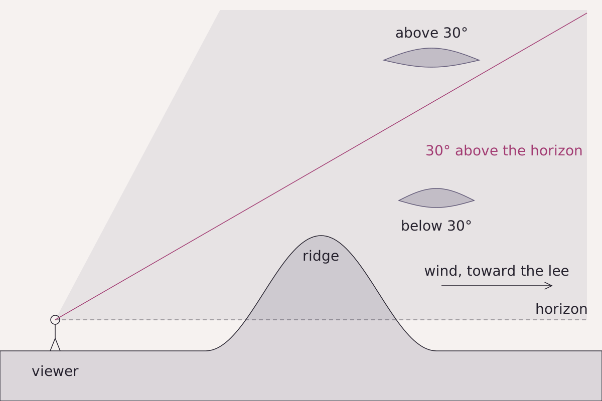
The view a lenticular cloud needs: the ridge, the sky above it and the sky on its downwind side. The 5° size test for broken-up altocumulus lenticularis applies only to elements seen more than 30° above the horizon.
Benchmark Schematic, not to scale; the sight line is drawn at 30° above the horizon from the viewer's eye; cloud positions follow the AMS Glossary entries for standing cloud and lenticularis.
"The view needed to read a lenticular cloud" by Meridian & Moraine, https://meridianandmoraine.com/aloft/lenticular-clouds/, licensed under CC BY 4.0 (https://creativecommons.org/licenses/by/4.0/).
Data: Definitions from the AMS Glossary of Meteorology (standing cloud, crest cloud, lenticularis), retrieved 2026-11-16
Several other clouds also hold their place near mountains, and the AMS groups them as standing clouds. The table sets them beside the lenticular form and ordinary altocumulus.
| Cloud | Where it sits | What it looks like |
|---|---|---|
| Lenticular cloud | Usually on wave crests over or downwind of a ridge, sometimes in a row downwind (AMS) | More or less isolated smooth lenses or almonds with sharp outlines (AMS) |
| Cap cloud | On or just above a single isolated peak (AMS) | A cloud hovering over the summit (AMS) |
| Crest cloud | Along a mountain range, on the ridge or slightly above and downwind of it (AMS) | A cloud lying along the ridge line (AMS) |
| Banner cloud | Trailing downwind from a sharp, isolated peak (AMS) | A plume that can look like snow blowing off the peak (AMS) |
| Ordinary altocumulus | Middle levels; the NWS definition names no peak or ridge | A patch, sheet or layer of small rounded elements, usually 1° to 5° wide (NWS) |
One caution comes from the AMS lenticularis entry itself: lens clouds also occur in regions without marked terrain, so a missing mountain does not rule one out. From a mountain top, the same kind of ridge view can show a different sight on the cloud below, the Brocken spectre.
The next time a smooth lens hangs near a ridge, find the ridge first, then note which side of it the cloud sits on. Look farther downwind for more lenses in a row, each a possible wave crest. Then line the cloud up with a fixed point on the skyline for a few minutes: a cloud that keeps its place beside that point is behaving like a standing cloud, and one that slides past it is drifting, not standing.
Next overpass
- Types of clouds: which of the ten genera a lens cloud belongs to, and at what height each genus sits.
- Shaded relief: the same kind of mountain drawn with light and shadow on a map, where the light's direction decides what reads as a ridge.
Sources
- National Weather Service, Observing Handbook No. 1: Marine Surface Weather Observations (Stennis Space Center, MS: NOAA National Weather Service, National Data Buoy Center, May 2010). www.weather.gov/media/marine/ObservingHandbook1_2…Read: pages 2-13, 2-14, 2-18, 2-57, 2-62, 2-63, 2-65, 2-67 and glossary pages 5-1 to 5-3
- American Meteorological Society, "mountain-wave cloud," Glossary of Meteorology. glossary.ametsoc.org/wiki/mountain-wave-cloud/Read: glossary entry, paraphrased
- American Meteorological Society, "lenticular cloud," Glossary of Meteorology. glossary.ametsoc.org/wiki/lenticular-cloud/Read: glossary entry, paraphrased
- American Meteorological Society, "lenticularis," Glossary of Meteorology. glossary.ametsoc.org/wiki/lenticularis/Read: glossary entry, paraphrased
- American Meteorological Society, "mountain wave," Glossary of Meteorology. glossary.ametsoc.org/wiki/mountain-wave/Read: glossary entry, paraphrased
- American Meteorological Society, "lee wave," Glossary of Meteorology. glossary.ametsoc.org/wiki/lee-wave/Read: glossary entry, paraphrased
- American Meteorological Society, "standing cloud," Glossary of Meteorology. glossary.ametsoc.org/wiki/standing-cloud/Read: glossary entry, paraphrased
- American Meteorological Society, "cap cloud," Glossary of Meteorology. glossary.ametsoc.org/wiki/cap-cloud/Read: glossary entry, paraphrased
- American Meteorological Society, "crest cloud," Glossary of Meteorology. glossary.ametsoc.org/wiki/crest-cloud/Read: glossary entry, paraphrased
- American Meteorological Society, "banner cloud," Glossary of Meteorology. glossary.ametsoc.org/wiki/banner-cloud/Read: glossary entry, paraphrased
- National Park Service, "Lewis and Clark used a sextant, you can use your hands!" Lewis and Clark National Historic Trail. www.nps.gov/articles/000/lewis-and-clark-used…Read: full text
Cite this page
The Reading Room. “Lenticular Clouds: Most Mark the Crest of a Mountain Wave.” Meridian & Moraine, published 16 November 2026. https://meridianandmoraine.com/aloft/lenticular-clouds/. Accessed on the date you read it.
How readings are checkedAll correctionsReport an error on this page (contact@meridianandmoraine.com)
More from Sky Reading
Sky Reading
Types of Clouds: Why ‘High’ Clouds Sit Lower Near the Poles
Image credit
"Cumulonimbus anvil, NOAA Photo Library image nssl0035" by NOAA Photo Library, NOAA Central Library; OAR/ERL/National Severe Storms Laboratory (NSSL) — https://commons.wikimedia.org/wiki/File:Cumulonimbus_cloud_-_NOAA.jpg — Public domain (US: U.S. Government work, made by a NOAA employee as part of official duties (17 U.S.C. §105))
Sky Reading
Double Rainbow: Why the Sky Between the Bows Is Darker
Image credit
"Double-Rainbow.jpg" by LeonardoWeiss — https://commons.wikimedia.org/wiki/File:Double-Rainbow.jpg — CC BY 3.0 (https://creativecommons.org/licenses/by/3.0/)
Sky Reading
Brocken Spectre: The Rings Center on Your Own Shadow’s Head
Image credit
"Le Spectre du Brocken, fig. 84, from L'atmosphère: météorologie populaire" by Unknown author — https://commons.wikimedia.org/wiki/File:Flammarion_Le_Spectre_du_Brocken_.jpg — Public domain (US: first published 1888, before 1931; EU: anonymous engraving first published 1888, more than 70 years ago (engraver not named)); modified: resized