Types of Clouds: Why ‘High’ Clouds Sit Lower Near the Poles
The Reading Room Published
Short answer
The ten types of clouds, cirrus to cumulonimbus, sort into high, middle and low levels. In the NWS handbook, high clouds start near 3 km over the poles, 6 km over the tropics.
Viewing card
- Where
- Worldwide, from the surface to about 18,300 m, the top of the tropical high level in the NWS table of approximate cloud heights
- Seen from
- The ground, looking up at the whole sky
- Captured
- NWS Observing Handbook No. 1 (2010); AMS Glossary of Meteorology
- Reading altitude
- Field of view: the whole sky, from the horizon to overhead; the NWS handbook estimates cloud cover in eighths of the sky
- Written by
- Air lifted and cooled to its dew point and just past saturation, so water vapor condenses into a visible aggregate of droplets or ice crystals
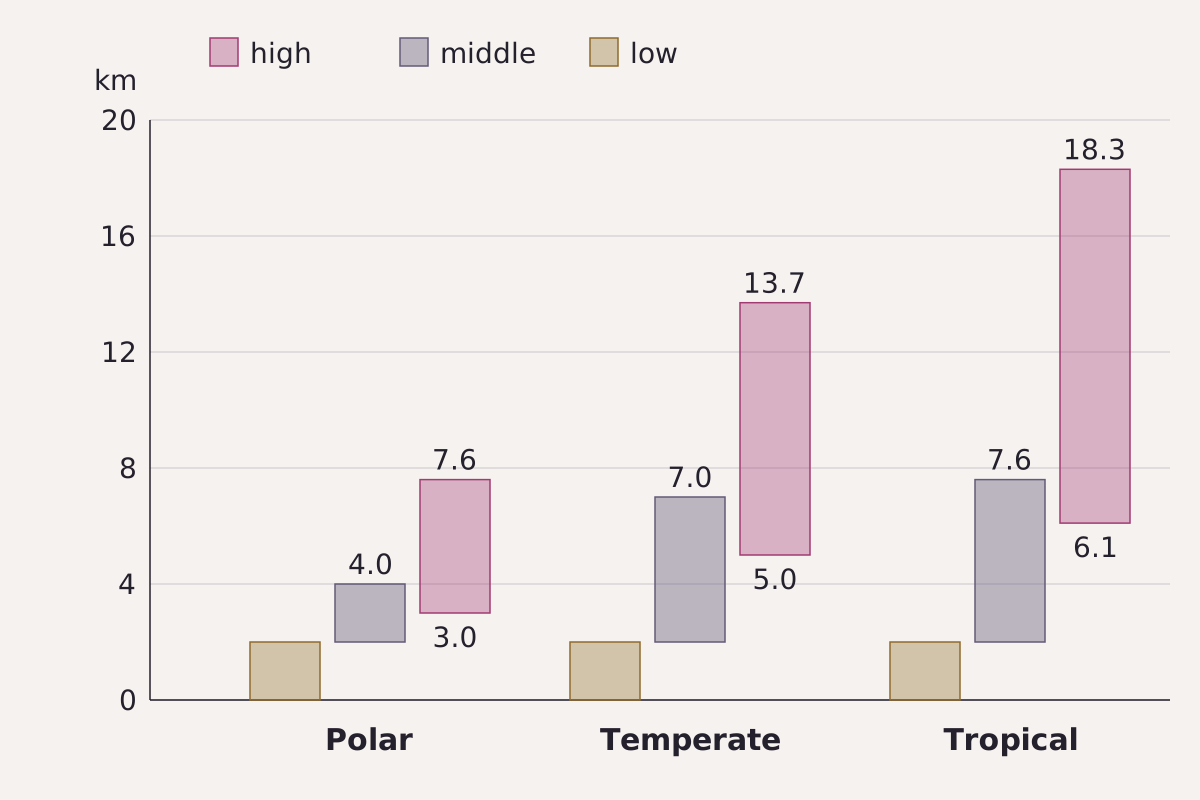
Approximate cloud heights by region, as tabled in the NWS Observing Handbook No. 1. Over polar regions the high level starts at 3 km, below the 7.6 km top of the tropical middle level.
Benchmark Each bar taken from this page's CSV; heights from the NWS Observing Handbook No. 1 (2010), page 2-13.
"Cloud levels by region" by Meridian & Moraine, https://meridianandmoraine.com/aloft/types-of-clouds/, licensed under CC BY 4.0 (https://creativecommons.org/licenses/by/4.0/).
Some afternoons the sky stacks three decks: white wisps on top, gray puffs in the middle, flat heaps below. Those decks have standard names, but “high,” “middle” and “low” are not fixed heights. A table in the U.S. National Weather Service's Observing Handbook No. 1 (2010) starts the high level at about 3 km over polar regions and at about 6 km over tropical regions.
According to the American Meteorological Society's Glossary of Meteorology, the classification in general use builds on a system Luke Howard introduced in 1803 and is the one adopted by the World Meteorological Organization. It sorts clouds into ten genera. The NWS handbook groups three as high (cirrus, cirrocumulus, cirrostratus), three as middle (altocumulus, altostratus, nimbostratus) and four as low (stratocumulus, stratus, cumulus, cumulonimbus).
The NWS handbook adds a rule of thumb: for a given cloud type, heights are higher in the tropics and during the summer months. The tropopause, the transition layer between the troposphere and the stratosphere, also sits higher in the tropics. The AMS Glossary puts it at 14 to 19 km in the tropics but about 10 km outside them, sometimes as low as 5 km.
What are the 10 types of clouds?
Each genus is defined by its look first. The short descriptions below paraphrase the definitions in the NWS handbook, and the level column follows its grouping into low, middle and high cloud types.
| Genus (abbreviation) | Level | What to look for |
|---|---|---|
| Cirrus (Ci) | High | Detached white filaments, patches or narrow bands; hair-like, with a silky sheen, or both |
| Cirrocumulus (Cc) | High | Thin white patch or layer of very small grains or ripples, without shading |
| Cirrostratus (Cs) | High | Transparent, whitish veil, hair-like or smooth, covering all or part of the sky |
| Altocumulus (Ac) | Middle | White or gray patches, sheets or layers of rounded masses or rolls, generally with shading |
| Altostratus (As) | Middle | Grayish or bluish sheet with parts thin enough to show the Sun vaguely, as through ground glass |
| Nimbostratus (Ns) | Middle | Heavy, often dark layer blurred by falling rain or snow; thick enough to blot out the Sun |
| Stratocumulus (Sc) | Low | Gray or whitish patches or sheets that almost always have dark parts |
| Stratus (St) | Low | Gray layer with a fairly uniform base; may give drizzle, ice prisms or snow grains |
| Cumulus (Cu) | Low | Detached, dense heaps with sharp outlines, rising as mounds or towers; tops often like cauliflower |
| Cumulonimbus (Cb) | Low | Heavy, dense mountain or towers; upper part nearly always flattened, often into an anvil |
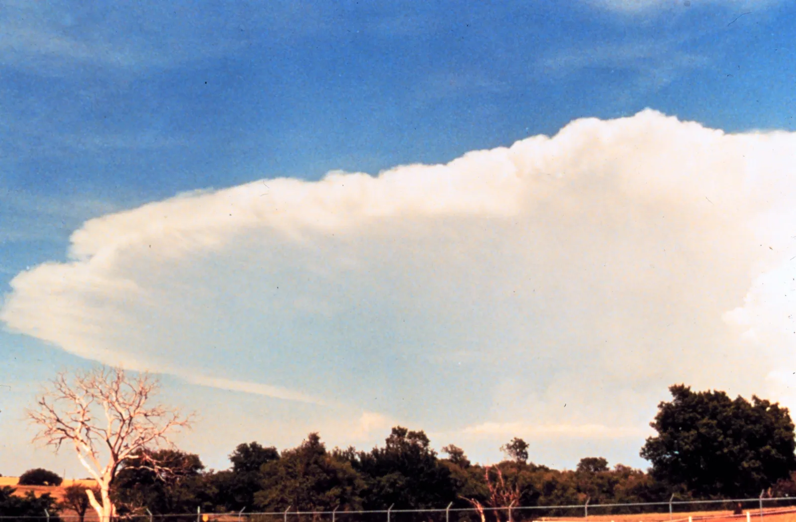
Cumulonimbus, its upper part flattened and spread out sideways. The NWS definition calls the flattening nearly always present and the spreading frequent.
"Cumulonimbus anvil, NOAA Photo Library image nssl0035" by NOAA Photo Library, NOAA Central Library; OAR/ERL/National Severe Storms Laboratory (NSSL) — https://commons.wikimedia.org/wiki/File:Cumulonimbus_cloud_-_NOAA.jpg — Public domain (US: U.S. Government work, made by a NOAA employee as part of official duties (17 U.S.C. §105))
Read a sky in that order, texture first and height second. The NWS handbook works the same way when ship observers estimate cloud height: first determine the type of the lowest cloud seen, then look up the normal height range for that type.
Some well-known sky shapes are not genera at all. The AMS Glossary describes mamma, pouch-like bulges hanging from a cloud's underside, as a supplementary feature that occurs mostly with six genera, from cirrus to cumulonimbus.
What makes a cloud in the first place?
The NWS handbook defines a cloud as a visible aggregate of minute water droplets or ice crystals in the atmosphere. A parcel of dry air lifted through the atmosphere cools at about 9.8°C per kilometer, roughly 5.4°F per 1,000 feet, the dry-adiabatic lapse rate given in the AMS Glossary. Air that cools to its dew point, the temperature at which saturation occurs, becomes saturated with water vapor.
Just past saturation, water vapor condenses onto cloud condensation nuclei, which the AMS Glossary describes as aerosol particles that attract water and can serve as the nuclei of cloud droplets. That lift, cool and condense sequence is the Written by line in the Viewing card above.
Where do the cloud names come from?
The system starts with Luke Howard. His 1803 paper “On the Modifications of Clouds,” printed in the Philosophical Magazine, named three simple modifications and gave each a Latin and an English definition. Cirrus was “parallel, flexuous, or diverging fibres,” cumulus “convex or conical heaps, increasing upward from a horizontal base,” and stratus “a widely extended, continuous, horizontal sheet, increasing from below.”
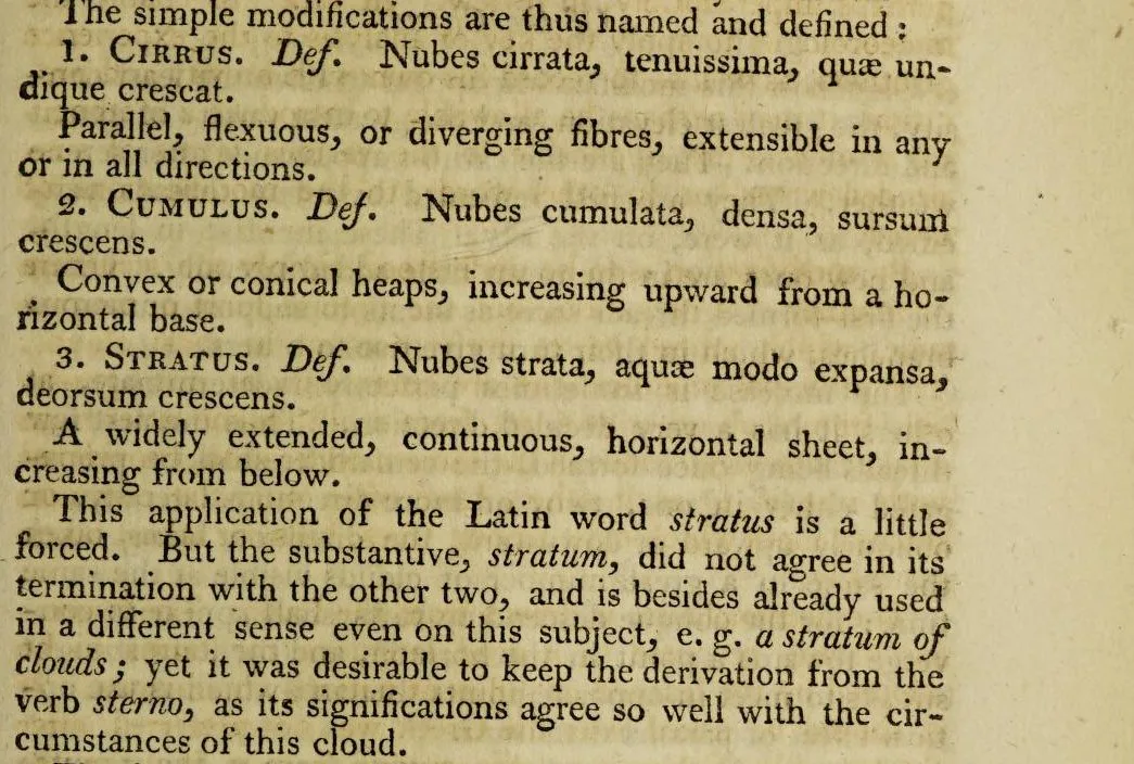
Page 99 of Luke Howard’s 1803 paper in the Philosophical Magazine, volume 16: the definitions of cirrus, cumulus and stratus, and the note on why stratus comes from the verb sterno.
"Page 99, from On the Modifications of Clouds (Philosophical Magazine, vol. 16)" by Luke Howard — https://archive.org/details/s2id13415870/page/n102 — Public domain (US: first published 1803; EU: author Luke Howard died 1864, more than 70 years ago; Internet Archive item marked with the Public Domain Mark); modified: cropped
Howard also explained the oddest of the three names. “This application of the Latin word stratus is a little forced,” he wrote, but he wanted “to keep the derivation from the verb sterno, as its significations agree so well with the circumstances of this cloud.” The noun stratum, he noted, was already used in a different sense, as in “a stratum of clouds.”
Howard's list already joined the names. It included cirro-cumulus and cirro-stratus as intermediate forms, and nimbus, “the rain cloud,” as a compound one. All ten modern genus names are built from his four words, with one added prefix in two of them: the NWS glossary defines alto- as a cloud prefix meaning middle level, next to cirro- for high level.
Read the ten names as the day's shorthand, a few Latin roots recombined to label what the air has written in water. Under the metaphor sits a plain rule: each name records a look (fibers, heaps or sheets), nimbo- or -nimbus marks rain, and the cirro- and alto- genera sit in the high and middle levels.
How high are high, middle and low clouds?
The AMS Glossary calls these groups cloud etages and gives a single set of heights with no split by latitude: high at 3 to 8 km, middle at 2 to 4 km and low from the surface to 2 km. The NWS handbook breaks the same three levels down by region in a table of approximate heights. That is where the levels start to move.
| Level | Polar regions | Temperate regions | Tropical regions |
|---|---|---|---|
| High (Ci, Cc, Cs) | 3,000–7,600 m (10,000–25,000 ft) | 5,000–13,700 m (16,500–45,000 ft) | 6,100–18,300 m (20,000–60,000 ft) |
| Middle (Ac, As, Ns) | 2,000–4,000 m (6,500–13,000 ft) | 2,000–7,000 m (6,500–23,000 ft) | 2,000–7,600 m (6,500–25,000 ft) |
| Low (St, Sc, Cu, Cb) | Surface–2,000 m (surface–6,500 ft) | Surface–2,000 m (surface–6,500 ft) | Surface–2,000 m (surface–6,500 ft) |
Download the cloud heights by region (CSV) (about this file)
One cell needs a note. The handbook prints the temperate high level in feet as “16,5000 to 45,000,” a misprint for 16,500, since the metric column beside it gives 5,000 m.
Now read across the high row, which runs from 3,000 to 7,600 m over polar regions and from 6,100 to 18,300 m over the tropics. So a polar high cloud at 4 km can sit below a tropical middle cloud at 7 km, and both fit the table.
Even within one region the levels overlap. In the polar column the middle level reaches 4,000 m and the high level begins at 3,000 m. A cloud at 3.5 km fits both by height alone, and only its shape can settle the genus.
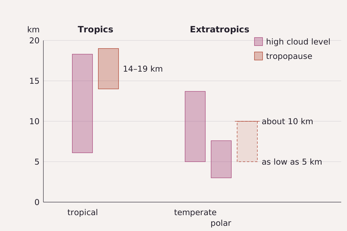
The tropopause drawn as ranges, not a line: 14 to 19 km in the tropics and about 10 km outside them, sometimes as low as 5 km, set beside the NWS high cloud level for each region.
Benchmark Schematic of ranges on one kilometer scale; tropopause heights from the AMS Glossary entry, cloud levels from the NWS Observing Handbook No. 1 (2010), page 2-13.
"Tropopause height beside the high cloud level" by Meridian & Moraine, https://meridianandmoraine.com/aloft/types-of-clouds/, licensed under CC BY 4.0 (https://creativecommons.org/licenses/by/4.0/).
Set the tropopause figures beside the table and they move together. In the tropics the tropopause sits at 14 to 19 km, near the 18,300 m top of the tropical high level. Outside the tropics it sits around 10 km and sometimes as low as 5 km, while the polar high level tops out at 7,600 m. Both sets of numbers are approximate, and the two sources split latitudes differently.
Which clouds break the level rules?
Four genera do not stay in one level, and the height classes in the AMS Glossary name them. Its high class includes occasionally altostratus and the tops of cumulonimbus. Its middle class takes altostratus and nimbostratus along with portions of cumulus and cumulonimbus, and its low class takes most cumulus and cumulonimbus bases and sometimes nimbostratus.
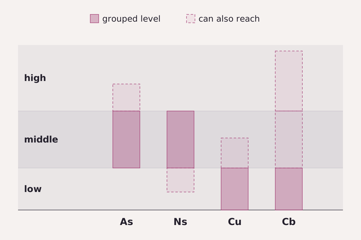
Four genera that cross level boundaries. Solid bars mark the level each is grouped under; dashed parts mark the other levels the AMS height classes and the NWS handbook allow.
Benchmark Schematic, not to scale; level membership from the AMS Glossary height classes and the NWS Observing Handbook No. 1 (2010).
"Four genera that cross level boundaries" by Meridian & Moraine, https://meridianandmoraine.com/aloft/types-of-clouds/, licensed under CC BY 4.0 (https://creativecommons.org/licenses/by/4.0/).
The NWS handbook adds that nimbostratus usually has its base under 6,500 feet, inside the low level, though the base may be higher. Cumulonimbus shows the stretch most clearly. The handbook describes a heavy, dense cloud with considerable vertical extent, in the form of a mountain or huge towers, its upper part nearly always flattened and often spread into an anvil or vast plume. Yet the NWS code still files it with the low clouds, where its base usually sits.
The ten genera work as a useful agreement among observers. Howard already saw why: a cloud formed in one modification “may pass into another,” he wrote. “Or it may continue a considerable time in an intermediate state, partaking of the characters of two modifications.” When a sky sits on a boundary, the line between two genera is a convention drawn for convenience.
How do you tell cirrocumulus, altocumulus and stratocumulus apart?
Three genera show fields of small cloudlets: cirrocumulus, altocumulus and stratocumulus. The NWS handbook separates them partly by apparent width, a test anyone can run from the ground. In its definitions, most of the regularly arranged elements are less than 1 degree wide in cirrocumulus, usually between 1 and 5 degrees in altocumulus and more than 5 degrees in stratocumulus.
| Genus | Apparent width of most elements |
|---|---|
| Cirrocumulus (Cc) | Less than 1° |
| Altocumulus (Ac) | Usually 1° to 5° |
| Stratocumulus (Sc) | More than 5° |
Download the ten genera with levels and width rules (CSV) (about this file)
Hold a hand out at arm's length. A National Park Service guide to measuring the sky with your hands gives the little finger at about 1 degree, the thumb at about 2 degrees and the fist at about 10 degrees. Hands and arms differ, so treat every hand reading here as rough.
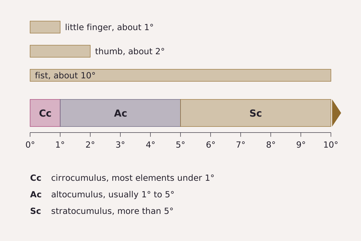
The hand test for cloudlet size: the NWS width cut-offs for cirrocumulus, altocumulus and stratocumulus, set against rough hand widths at arm’s length.
Benchmark Schematic, not to scale for any one hand; width cut-offs from the NWS Observing Handbook No. 1 (2010), hand widths from a National Park Service guide.
"The hand test for cloudlet size" by Meridian & Moraine, https://meridianandmoraine.com/aloft/types-of-clouds/, licensed under CC BY 4.0 (https://creativecommons.org/licenses/by/4.0/).
Cloudlets that mostly hide behind your little finger point to cirrocumulus. Cloudlets mostly wider than half a fist, about 5 degrees, point to stratocumulus, and anything in between points to altocumulus.
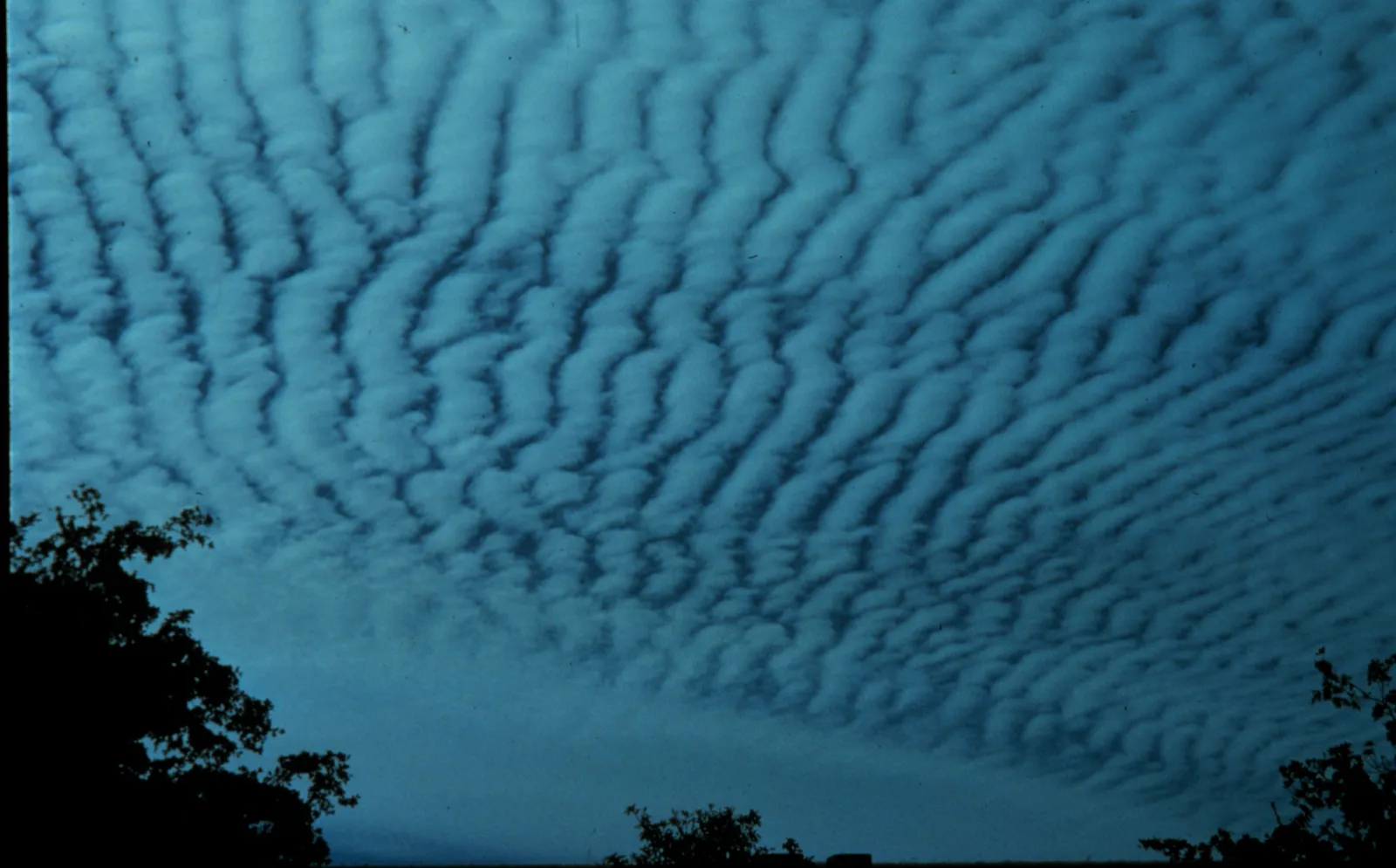
Altocumulus: rows of rounded masses with shaded undersides, the kind of field the width test is meant for.
"Altocumulus clouds, NOAA Photo Library image wea00039 (Historic NWS Collection)" by Ralph F. Kresge — https://commons.wikimedia.org/wiki/File:Altocumulus_clouds2_-_NOAA.jpg — Public domain (US: U.S. Government work, made by a NOAA employee as part of official duties (17 U.S.C. §105))
Shading is a second clue. The NWS definitions describe cirrocumulus as without shading and altocumulus as generally with shading, while stratocumulus almost always has dark parts.
How do you read a gray, layered sky?
Sheet clouds have no cloudlets to measure, so read the light through them instead. Before looking anywhere near the Sun, hide it completely behind a building or a post, never look straight at it, and never aim binoculars or a camera viewfinder at it. At night, the Moon behind the same sheet makes an easier test.
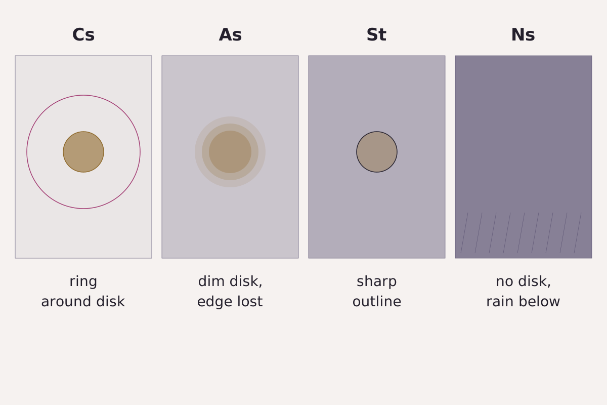
What happens to the Sun’s disk behind four sheet clouds, after the NWS definitions: a large ring with cirrostratus, a dim ground-glass disk with altostratus, a clear outline with stratus and no disk with nimbostratus.
Benchmark Schematic, not to scale; light behavior from the NWS Observing Handbook No. 1 (2010) definitions.
"Light through four sheet clouds" by Meridian & Moraine, https://meridianandmoraine.com/aloft/types-of-clouds/, licensed under CC BY 4.0 (https://creativecommons.org/licenses/by/4.0/).
The NWS definitions sort the four sheets by what happens to that light. Altostratus has parts thin enough to reveal the Sun at least vaguely, as through ground glass. When the Sun is visible through stratus, its outline is clearly discernible. Nimbostratus is thick enough to blot out the Sun or Moon, and its rain or snow in most cases reaches the ground.
Cirrostratus, the thinnest veil, generally produces halo phenomena such as a large ring around the Sun or Moon, while much smaller colored rings hugging the disk are a corona, a different effect that the AMS Glossary traces mainly to cloud droplets rather than ice crystals. Falling rain with a low Sun behind you gives a different reading of the same sky, the one used for a double rainbow.
Are there clouds above the ten genera?
Yes, and they sit outside the genus system. The AMS Glossary places polar stratospheric clouds, also called nacreous or mother-of-pearl clouds, at heights of about 20 to 30 km, seen mainly over Antarctica and also over Scotland, Scandinavia and Alaska. Noctilucent clouds, thin silvery-blue cirrus-like clouds seen in summer twilight above 50° latitude, are in its words “the highest visible clouds in the atmosphere,” at about 85 km.
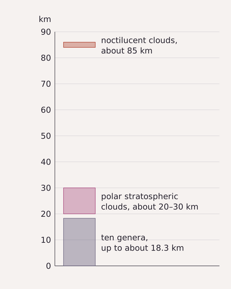
Cloud heights on one scale: the ten genera reach about 18 km in the NWS table, and the AMS Glossary places polar stratospheric clouds at about 20 to 30 km and the highest visible clouds at about 85 km.
Benchmark Schematic, heights on one linear kilometer scale; the genus range from the NWS Observing Handbook No. 1 (2010), higher clouds from AMS Glossary entries.
"Cloud heights above the ten genera" by Meridian & Moraine, https://meridianandmoraine.com/aloft/types-of-clouds/, licensed under CC BY 4.0 (https://creativecommons.org/licenses/by/4.0/).
At about 85 km those highest clouds float about 11 times higher than the 7,600 m top of the polar high level.
How do you read the next sky?
The reading altitude for cloud genera is a field of view, not a height: the whole sky, from the horizon to overhead, the same sky the NWS handbook divides into eighths when observers estimate cloud cover. The handbook also tells ship observers that it is best to keep a close, continuous watch on the development of clouds. Cloud patterns can be read from orbit too, as in a von Kármán vortex street trailing behind an island, but from the ground four passes are enough.
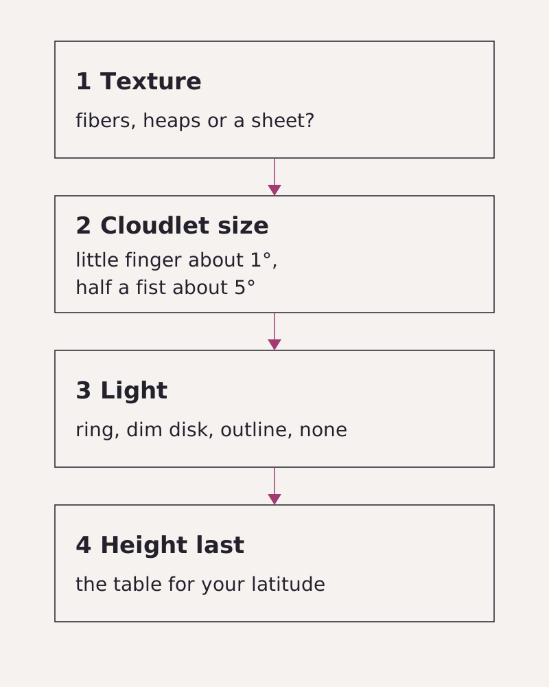
Four passes for naming a cloud, in the order this page uses: texture, cloudlet size, light, then height. The numbered list below gives the same steps as text.
Benchmark Schematic; steps drawn from the NWS Observing Handbook No. 1 (2010) definitions and height table, hand widths from a National Park Service guide.
"Four passes for naming a cloud" by Meridian & Moraine, https://meridianandmoraine.com/aloft/types-of-clouds/, licensed under CC BY 4.0 (https://creativecommons.org/licenses/by/4.0/).
- Texture. Hair-like fibers point to cirrus or cirrostratus. Heaps and towers point to cumulus or cumulonimbus. A field of cloudlets or a plain sheet needs the next two steps.
- Cloudlet size. Pick a field well away from the Sun. Compare several cloudlets with your little finger and with half a fist, roughly 1 and 5 degrees at arm's length, and go by what most of them show.
- Light. For a sheet, hide the Sun behind a building or post first, or wait for the Moon. A large ring points to cirrostratus, a dim ground-glass Sun to altostratus, a sharp outline to stratus, and a hidden Sun with falling rain or snow to nimbostratus.
- Height last. If you know the height, choose from the genera listed for your latitude in the table above.
Next time a field of cloudlets drifts overhead, hold your little finger up against a few cloudlets before you name the field.
Next overpass
- Atmospheric river: The same sky read from orbit, as a long, narrow corridor of water vapor.
- Lenticular clouds: A lens-shaped cloud that stays in place over a mountain wave while the air blows through it.
Sources
- National Weather Service, Observing Handbook No. 1: Marine Surface Weather Observations (Stennis Space Center, MS: NOAA National Weather Service, National Data Buoy Center, May 2010). www.weather.gov/media/marine/ObservingHandbook1_2…Read: pages 2-13, 2-14, 2-18, 2-57, 2-62, 2-63, 2-65, 2-67 and glossary pages 5-1 to 5-3
- American Meteorological Society, "cloud classification," Glossary of Meteorology. glossary.ametsoc.org/wiki/cloud-classification/Read: glossary entry, paraphrased
- American Meteorological Society, "cloud etage," Glossary of Meteorology. glossary.ametsoc.org/wiki/cloud-etage/Read: glossary entry, paraphrased
- American Meteorological Society, "tropopause," Glossary of Meteorology (term edited 24 July 2026). glossary.ametsoc.org/wiki/tropopause/Read: glossary entry, paraphrased
- American Meteorological Society, "adiabatic lapse rate," Glossary of Meteorology. glossary.ametsoc.org/wiki/adiabatic-lapse-rate/Read: glossary entry, paraphrased
- American Meteorological Society, "cloud condensation nuclei," Glossary of Meteorology. glossary.ametsoc.org/wiki/cloud-condensation-nuclei/Read: glossary entry, paraphrased
- American Meteorological Society, "mamma," Glossary of Meteorology. glossary.ametsoc.org/wiki/mamma/Read: glossary entry, paraphrased
- American Meteorological Society, "corona," Glossary of Meteorology (term edited 13 August 2018). glossary.ametsoc.org/wiki/corona/Read: glossary entry, paraphrased
- American Meteorological Society, "polar stratospheric clouds," Glossary of Meteorology. glossary.ametsoc.org/wiki/polar-stratospheric-clouds/Read: glossary entry, paraphrased
- American Meteorological Society, "noctilucent clouds," Glossary of Meteorology. glossary.ametsoc.org/wiki/noctilucent-clouds/Read: glossary entry, paraphrased
- Luke Howard, "On the Modifications of Clouds, and on the Principles of Their Production, Suspension, and Destruction," Philosophical Magazine 16, no. 62 (July 1803), beginning on page 97. archive.org/details/s2id13415870/page/n102Read: pages 97–99, checked against the page images
- National Park Service, "Lewis and Clark used a sextant, you can use your hands!" Lewis and Clark National Historic Trail. www.nps.gov/articles/000/lewis-and-clark-used…Read: full text
Cite this page
The Reading Room. “Types of Clouds: Why ‘High’ Clouds Sit Lower Near the Poles.” Meridian & Moraine, published 16 November 2026. https://meridianandmoraine.com/aloft/types-of-clouds/. Accessed on the date you read it.
How readings are checkedAll correctionsReport an error on this page (contact@meridianandmoraine.com)
More from Sky Reading
Sky Reading
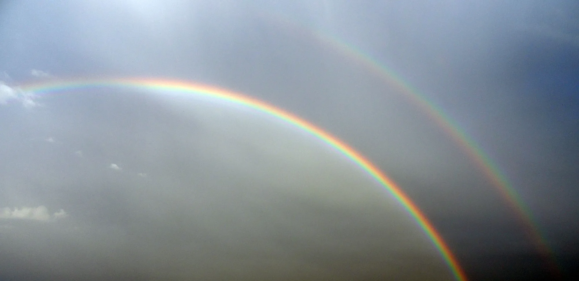
Double Rainbow: Why the Sky Between the Bows Is Darker
Image credit
"Double-Rainbow.jpg" by LeonardoWeiss — https://commons.wikimedia.org/wiki/File:Double-Rainbow.jpg — CC BY 3.0 (https://creativecommons.org/licenses/by/3.0/)
 Illustration
Sky Reading
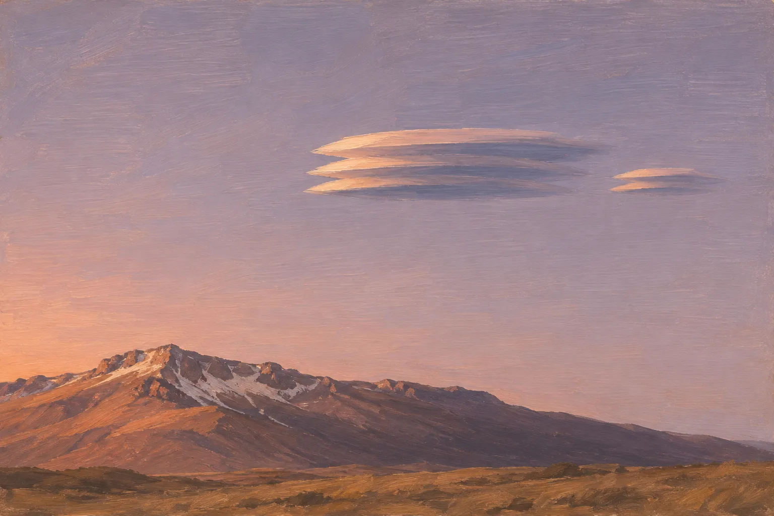
Lenticular Clouds: Most Mark the Crest of a Mountain Wave
Image credit (illustration)
Illustration: Meridian & Moraine. Generated illustration — not a photograph, satellite image or map; not to scale. Reuse: CC BY 4.0 (https://creativecommons.org/licenses/by/4.0/) to the extent any rights apply.
Sky Reading
Brocken Spectre: The Rings Center on Your Own Shadow’s Head
Image credit
"Le Spectre du Brocken, fig. 84, from L'atmosphère: météorologie populaire" by Unknown author — https://commons.wikimedia.org/wiki/File:Flammarion_Le_Spectre_du_Brocken_.jpg — Public domain (US: first published 1888, before 1931; EU: anonymous engraving first published 1888, more than 70 years ago (engraver not named)); modified: resized