Alluvial Fan: In Death Valley, Dark Is Older, Up to a Point
The Reading Room Published
Short answer
In Death Valley, an alluvial fan is a gravel deposit that floods and debris flows spread where a canyon opens onto a valley floor. There, USGS dating puts dark, varnished surfaces older than pale channels.
Viewing card
- Where
- 36.222°N 116.900°W (frame center); 16 × 10.7 km
- Seen from
- Sentinel-2B MSI, bands 4-3-2 (true color)
- Captured
- 2024-04-02 18:44 UTC · sentinel-2-c1-l2a, baseline 05.10
- Reading altitude
- 10 m pixels; frame 16 × 10.7 km
- Written by
- Floods and debris flows from Hanaupah Canyon spread gravel east; surfaces the streams abandon stabilize and gain varnished desert pavement (per USGS PP 1755)
This card as data (CSV) About this file
Data: Scene metadata: Copernicus Sentinel-2 via Earth Search (Element 84); cause: U.S. Geological Survey Professional Paper 1755 (2008), public domain
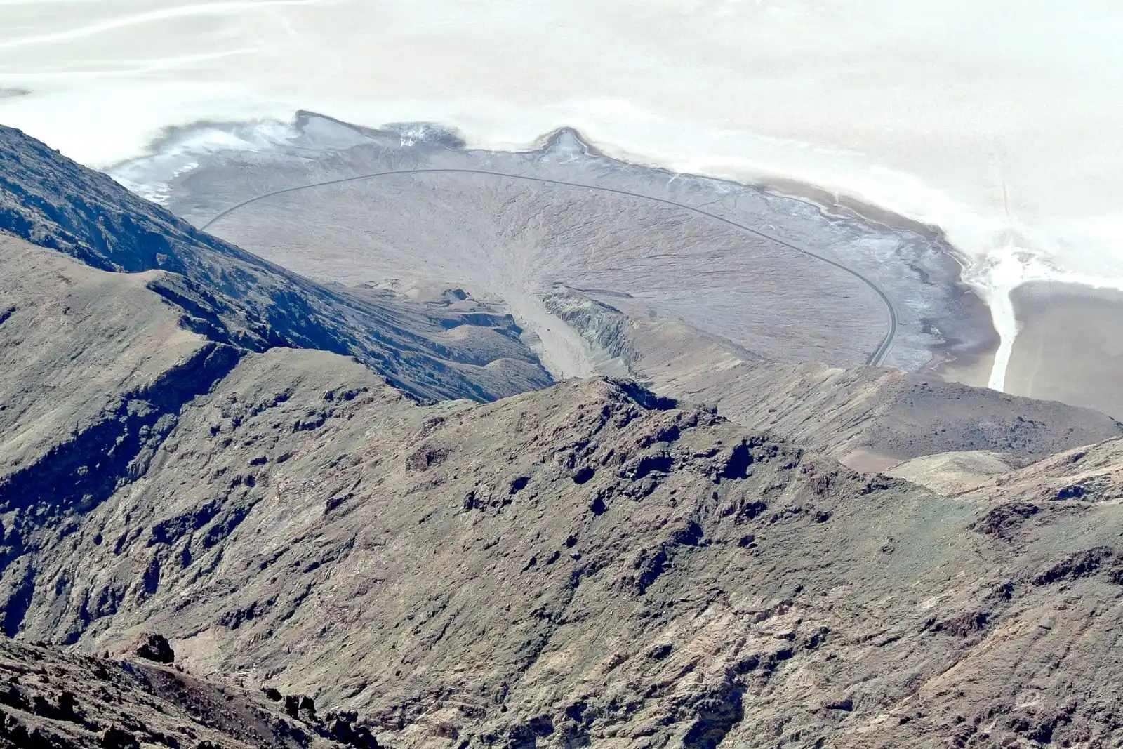
An alluvial fan below Dante's View in Death Valley, according to the photographer's file record. Gray gravel spreads from a narrow canyon onto the white salt pan, and a road arcs across the face of the fan.
"Death Valley Alluvial Fan from Dante's View" by Wilson44691 — https://commons.wikimedia.org/wiki/File:Death_Valley_Alluvial_Fan_from_Dante%27s_View.JPG — CC0 1.0 (https://creativecommons.org/publicdomain/zero/1.0/); modified: cropped, resized
Below a canyon mouth, a gray apron of gravel spreads onto the valley floor like an opened fan. Look closer and the apron is patchy. Dark, smooth tracts lie between paler strips, and on Death Valley's Hanaupah Canyon fan the dark tracts are the older ground. A 2008 U.S. Geological Survey report, Professional Paper 1755, dated those surfaces by measuring chlorine-36, an isotope that builds up in rock lying within about 2 meters of the ground surface.
What is an alluvial fan?
The 2008 report describes how fans grow in Death Valley's dry climate. During floods, streams and debris flows lay down gravel fairly fast, and the active streams still running across the fans are the ones that built them. When a stream cuts down or shifts its channel, the surface it leaves stops getting new gravel. The report calls that surface stabilized, and from then on soil starts to form on it.
According to the report, the two sides of the valley build different fans. On the west, fans fed by the Panamint Range are massive and run together. Those on the east, along the Black Mountains fault zone, are smaller and steeper, and the report puts their smaller size down to fast vertical movement and basin subsidence across that fault.
Hanaupah Canyon feeds one of the western fans. The report sampled modern gravel in the active channel at the fan's apex, where the canyon meets the range front, at 494 meters above sea level, and again near the toe at 61 meters. By their grid coordinates the two sites are about 5.4 kilometers apart, an average drop of about 8 meters in every 100.
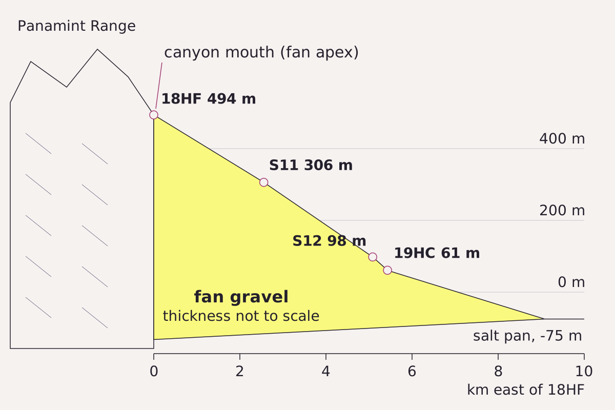
The Hanaupah Canyon fan in profile, from its apex at the canyon mouth down to the salt pan. Points are sample sites from the 2008 USGS report, placed by their grid coordinates and printed elevations.
Benchmark Schematic, not to scale below the surface; site distances and elevations from USGS PP 1755 Tables A1 and A2, vertical scale exaggerated about 8 times; salt-pan level from the report's figure 3 caption; pan edge drawn at the midpoint of the report's 3–4 km from S8 to the Devils Golf Course.
"Profile down the Hanaupah Canyon alluvial fan, with USGS sample sites" by Meridian & Moraine, https://meridianandmoraine.com/satellite/alluvial-fan/, licensed under CC BY 4.0 (https://creativecommons.org/licenses/by/4.0/).
Data: Site coordinates and elevations from U.S. Geological Survey Professional Paper 1755 (Machette, Slate and Phillips, 2008), public domain
To see the same slope drawn as lines on a map, read the rules for contour lines.
Reading Hanaupah Canyon's fan from orbit
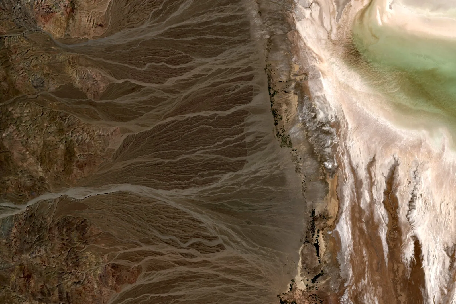
In a Sentinel-2 image from April 2, 2024, the Hanaupah Canyon fan spreads east from the canyon mouth near the left edge toward the salt pan at the right. Visible in imagery: dark brown tracts with a smooth texture, cut by paler gray strips that branch and rejoin as they run downslope. The sample sites at the apex and near the toe alone lie about 5.4 kilometers apart by grid coordinates, more than 500 of the image's 10-meter pixels.
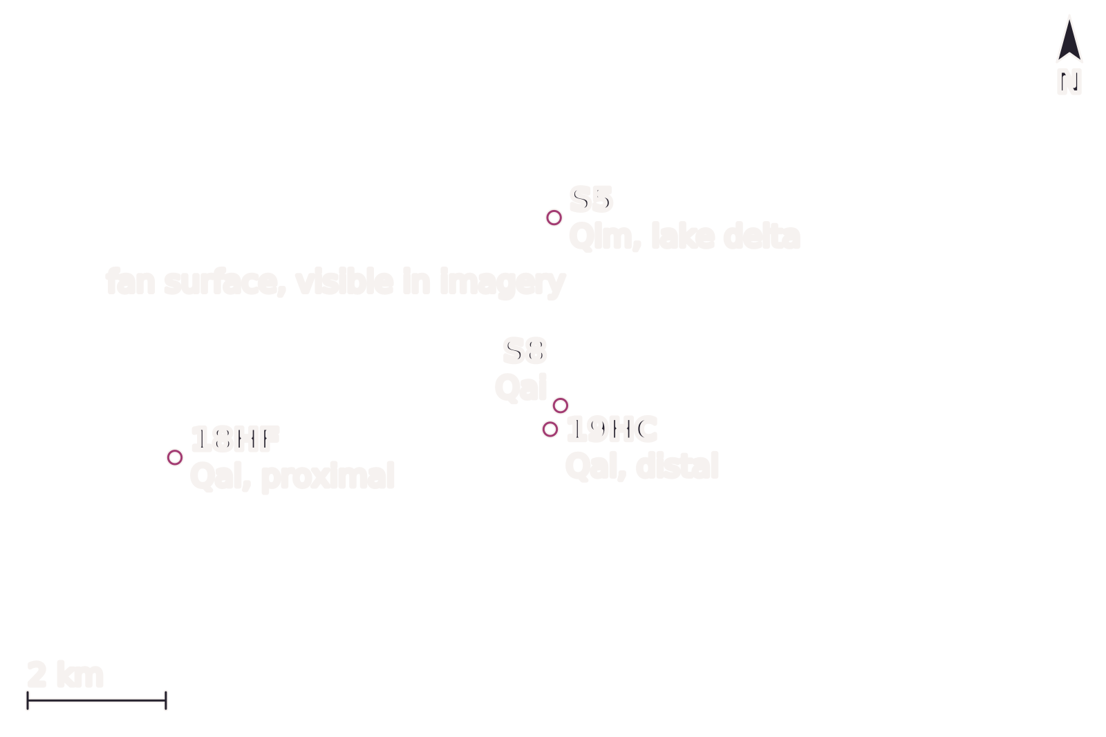
Those shades are only shapes and colors until a source ties them to a place. The labels on the image mark only sites that the 2008 report names and locates: 18HF and 19HC in active channels of modern gravel, S8 on unit Qai, and S5 on a lake delta, unit Qlm. Each site's NAD27 latitude and longitude from the report, which match its UTM grid coordinates within 2 meters, were converted to the image's frame, and each lands within one pixel.
Two of those labels cross the ground-truth gap side by side. S8, which the report places on unit Qai, sits on a dark tract; 19HC, modern gravel from an active channel, sits on a pale strip about 375 meters to the south-southwest by grid coordinates. Every other dark or pale patch in the frame is a reading visible in imagery only.
Open the image full size · annotation layer (SVG)
The Hanaupah Canyon fan on April 2, 2024, in Sentinel-2 true color. Gravel spreads east from the canyon mouth toward the salt pan of Death Valley, and darker and paler surfaces sit side by side on the fan. Points are sample sites from USGS Professional Paper 1755. North is up, with the image grid less than 0.1° off true north; the frame is about 16 km wide.
Benchmark Sentinel-2 L2A scene S2B_T11SNA_20240402T183856_L2A (sentinel-2-c1-l2a, baseline 05.10); bands 4-3-2 with one stretch 0.0726–0.5900, gamma 1.35; 10 m pixels, not enlarged; scale bar within 0.02% of the geodesic distance between its ends; north arrow at true north for the frame center; 4 source points converted from NAD27 placed within 1 pixel.
Image
"Hanaupah Canyon alluvial fan, Death Valley, California true-color composite, Sentinel-2 L2A scene S2B_T11SNA_20240402T183856_L2A via Earth Search (Element 84)" by Meridian & Moraine — https://earth-search.aws.element84.com/v1/collections/sentinel-2-c1-l2a/items/S2B_T11SNA_20240402T183856_L2A — Copernicus Sentinel data legal notice (https://sentinels.copernicus.eu/documents/247904/690755/Sentinel_Data_Legal_Notice); modified: cropped, resampled, color-stretched; rights notice: Contains modified Copernicus Sentinel data 2024
Annotation layer
"Annotation layer for Hanaupah Canyon alluvial fan, Death Valley, California (2024)" by Meridian & Moraine, https://meridianandmoraine.com/satellite/alluvial-fan/, licensed under CC BY 4.0 (https://creativecommons.org/licenses/by/4.0/).
Data: Sample-site coordinates from U.S. Geological Survey Professional Paper 1755 (Machette, Slate and Phillips, 2008), Tables A1 and A2, NAD27, public domain
The image marks only four of the report's sites. For S11, a dated Qai site high on the fan, Table A1 prints a longitude that falls about 2 kilometers east of the spot its UTM grid coordinates give. This page follows the UTM coordinates for S11, which fit the table's own note placing the site 5.0 kilometers west of West Side Road. The same habit of matching a color seen from orbit to a published source carries over to the rings of the Richat Structure.
Why are the darker surfaces older?
The report describes the intermediate-age fans, unit Qai, as having “a relatively smooth, densely packed desert pavement formed by well-varnished (blackened) clasts.” Desert pavement is a layer of stones packed tightly at the ground surface. Well-varnished means those stones have darkened. Mappers lean on the difference: the base map behind the study separated units partly by surface color tone, alongside landform and height above the active channel.
Once a stream abandons a surface, gravel stops arriving and the surface stabilizes, while the active channels keep laying down fresh gravel. The report's sketch of how surfaces change shows weak pavement on young gravel, moderate pavement on unit Qay and strong pavement on Qai. In the river's cursive, the pale channels read as fresh strokes written across older lines. Only those channels still receive new gravel, so they stay pale while the abandoned surfaces beside them darken.
The chlorine-36 dates bear that order out: Professional Paper 1755 puts unit Qai at about 100 to 40 ka (thousand years ago), with a mean of about 70 ka. On the Hanaupah fan itself, four Qai sites gave 39, 66, 72 and 96 thousand years, and the report reads the youngest, at S8, as probably an eroded profile. The dates belong to the gravel under the pavement. The report did not date the pavement itself, because it is commonly much younger than the deposit beneath.
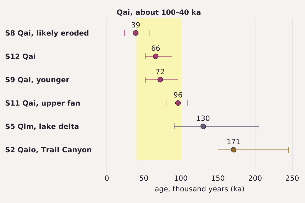
Chlorine-36 depth-profile ages from the 2008 USGS report, Table 5. Dots are best ages; bars run between the ages computed for the minimum and maximum erosion rates. The shaded band is the report's range for unit Qai, about 100 to 40 thousand years.
Benchmark Ages from USGS PP 1755 Table 5, the same values as each row of this page's CSV.
"Chlorine-36 ages of Hanaupah fan surfaces, the lake delta and the Trail Canyon fan" by Meridian & Moraine, https://meridianandmoraine.com/satellite/alluvial-fan/, licensed under CC BY 4.0 (https://creativecommons.org/licenses/by/4.0/).
Data: Ages from U.S. Geological Survey Professional Paper 1755 (Machette, Slate and Phillips, 2008), Table 5, public domain
Darker does not keep meaning older forever. The report says fans older than Qai are more dissected and carry strong carbonate at the surface. Its Table A4 lists pavement “mostly eroded” on units Qao and QTa, with a white carbonate layer, the K horizon, at the surface. For Qao it gives only a minimum age, more than 260 thousand years, from a single boulder dated in an earlier study.
| Unit | Site | Surface, per the 2008 report | Best age (ka) | Range at min.–max. erosion rate (ka) |
|---|---|---|---|---|
| Qal | 18HF, 19HC | Modern gravel in active channels | none | none |
| Qai | S8 | Varnished pavement; profile probably eroded | 39 | 24–58 |
| Qai | S12 | Varnished pavement, intact surface | 66 | 52–88 |
| Qai | S9 | Younger phase of Qai below the main surface | 72 | 52–96 |
| Qai | S11 | Varnished pavement, upper fan | 96 | 80–109 |
| Qlm | S5 | Lake delta; better-sorted, rounded, platy pebbles | 130 | 91–205 |
| Qaio | S2, Trail Canyon fan | Pavement well packed, locally eroded | 171 | 150–245 |
| Qao | not sampled; one boulder, earlier study | Pavement mostly eroded; white K horizon | more than 260 (minimum) | none |
Download the Hanaupah fan surfaces (CSV) (about this file) Data: Values from U.S. Geological Survey Professional Paper 1755 (Machette, Slate and Phillips, 2008), public domain
Fan or delta?
Not every gravel body on the Hanaupah fan was laid down by the fan. At the north end of the fan complex, the 2008 report maps unit Qlm, the remnant of a shoreline delta that streams from Hanaupah Canyon built into Lake Manly. The remnant stands well above the Qai gravel to its south. Lake Manly filled the basin several times during the Quaternary, and the top of this delta stands at 30 meters above sea level.
Two clues set the delta apart. Its surface pebbles are better sorted, rounded and platy than fan clasts, an observation the report credits to Ibbeken and colleagues in 1998; sorted means the pebbles are closer to one size. Exposures on the delta's north flank also show bottomset and foreset beds, and the report's photograph shows the foreset beds dipping moderately east, toward the valley floor.
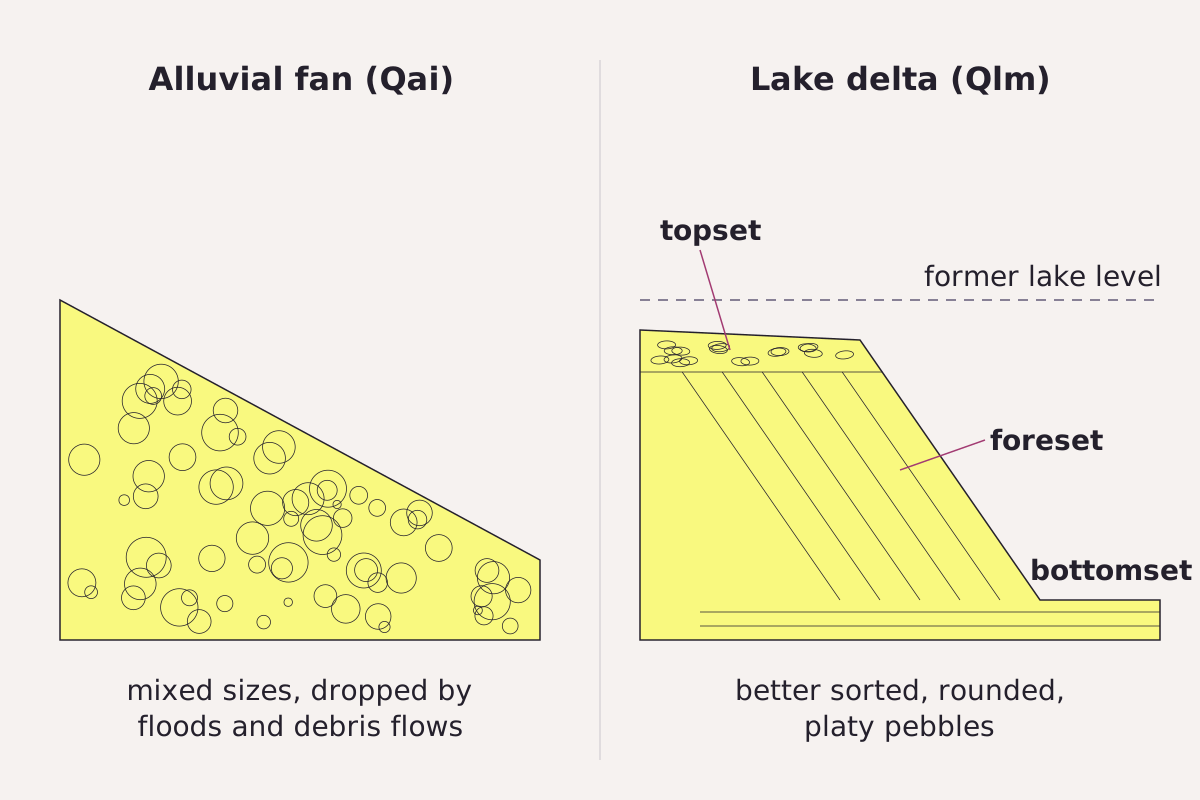
A fan and a lake delta side by side, drawn from the 2008 USGS description of the Hanaupah Canyon fan complex: mixed fan gravel on one side, and on the other a delta with topset, foreset and bottomset beds of better-sorted pebbles.
Benchmark Schematic, not to scale; bed names and pebble description from USGS PP 1755 (page 6 and figure 4).
"Fan gravel and lake-delta gravel compared, Hanaupah Canyon fan complex" by Meridian & Moraine, https://meridianandmoraine.com/satellite/alluvial-fan/, licensed under CC BY 4.0 (https://creativecommons.org/licenses/by/4.0/).
Data: Description from U.S. Geological Survey Professional Paper 1755 (Machette, Slate and Phillips, 2008), public domain
The delta also dates older than the Qai surfaces around it. A chlorine-36 profile at S5 gave about 130 ka, give or take tens of thousands of years, and Professional Paper 1755 ties it to a high stand of Lake Manly at about that time. In the satellite image, S5 sits on a dark tract much like the one at S8, visible in imagery, so color alone does not mark the delta.
On the next desert fan in a true-color image, trace the pale strips upslope to the canyon mouth first; on the Hanaupah fan, one such strip carries the report's modern channel gravel at 19HC. Then look at the dark tracts between the strips, and find a published map or date before reading a pale strip as an active channel, a dark patch as older fan, or a raised patch near the toe as part of the fan at all.
Next overpass
- Oxbow lake: another shape a river leaves behind, this time on the floodplain of a big river.
- How to read a geologic map: on a geologic map, one fan splits into several colors, one for each unit.
Sources
- Michael N. Machette, Janet L. Slate and Fred M. Phillips, Terrestrial Cosmogenic-Nuclide Dating of Alluvial Fans in Death Valley, California, U.S. Geological Survey Professional Paper 1755 (Reston, Virginia: U.S. Geological Survey, 2008), 45 p. pubs.usgs.gov/pp/1755/downloads/PP1755_508.pdfRead: full text; abstract (p. 1), pages 2, 5–12, 21–22, Tables 1–3 and 5, Tables A1–A4 and figures 3–5 used
- Copernicus Sentinel-2B MSI Level-2A scene S2B_T11SNA_20240402T183856_L2A (collection sentinel-2-c1-l2a, processing baseline 05.10), STAC item via Earth Search (Element 84). earth-search.aws.element84.com/v1/collections/sentinel-2-c1-l2a/…Read: scene metadata: capture time, platform, processing baseline, cloud cover, pixel grid
Cite this page
The Reading Room. “Alluvial Fan: In Death Valley, Dark Is Older, Up to a Point.” Meridian & Moraine, published 16 November 2026. https://meridianandmoraine.com/satellite/alluvial-fan/. Accessed on the date you read it.
How readings are checkedAll correctionsReport an error on this page (contact@meridianandmoraine.com)
More from Read from Orbit
Read from Orbit
Oxbow Lake: A River Gets Shorter by Bending Too Far
Image credit
"Raccourci Lake (Old River), Louisiana true-color composite, Sentinel-2 L2A scene S2A_T15RXQ_20241021T165322_L2A via Earth Search (Element 84)" by Meridian & Moraine — https://earth-search.aws.element84.com/v1/collections/sentinel-2-c1-l2a/items/S2A_T15RXQ_20241021T165322_L2A — Copernicus Sentinel data legal notice (https://sentinels.copernicus.eu/documents/247904/690755/Sentinel_Data_Legal_Notice); modified: cropped, resampled, color-stretched; rights notice: Contains modified Copernicus Sentinel data 2024
 Illustration
Read from Orbit
Atmospheric River: Moving Water Vapor, Not a River of Cloud
Image credit (illustration)
Illustration: Meridian & Moraine. Generated illustration — not a photograph, satellite image or map; not to scale. Reuse: CC BY 4.0 (https://creativecommons.org/licenses/by/4.0/) to the extent any rights apply.
Read from Orbit
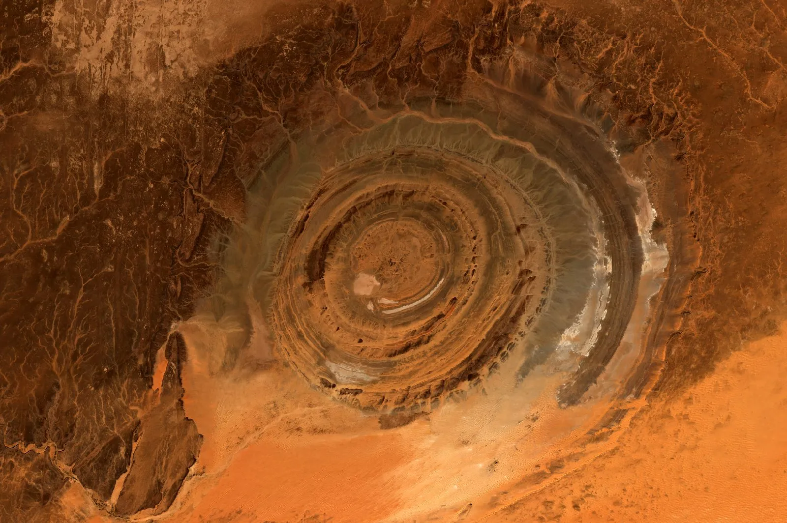
Richat Structure: A Worn-Down Dome, Not an Impact Crater
Image credit
"Richat Structure, Adrar, Mauritania true-color composite, Sentinel-2 L2A scene S2A_T29QKD_20240126T111440_L2A via Earth Search (Element 84)" by Meridian & Moraine — https://earth-search.aws.element84.com/v1/collections/sentinel-2-c1-l2a/items/S2A_T29QKD_20240126T111440_L2A — Copernicus Sentinel data legal notice (https://sentinels.copernicus.eu/documents/247904/690755/Sentinel_Data_Legal_Notice); modified: cropped, resampled, color-stretched; rights notice: Contains modified Copernicus Sentinel data 2024