Oxbow Lake: A River Gets Shorter by Bending Too Far
The Reading Room Published
Short answer
An oxbow lake forms when two bends of a meandering river meet: the river bypasses the loop between them and takes the shorter path, leaving the old loop as a curved lake beside the channel.
Viewing card
- Where
- 30.875°N 91.600°W (frame center); 16 × 10.7 km
- Seen from
- Sentinel-2A and Sentinel-2B MSI, bands 4-3-2 (true color)
- Captured
- 2018-10-28 16:54 UTC · sentinel-2-c1-l2a, baseline 05.00 / 2024-10-21 16:55 UTC · sentinel-2-c1-l2a, baseline 05.11
- Reading altitude
- 10 m pixels; frame 16 × 10.7 km
- Written by
- An incomplete cutoff of the Mississippi River left this oxbow lake, per USGS WRI 99-4292 (1999)
Open the image full size · annotation layer (SVG)
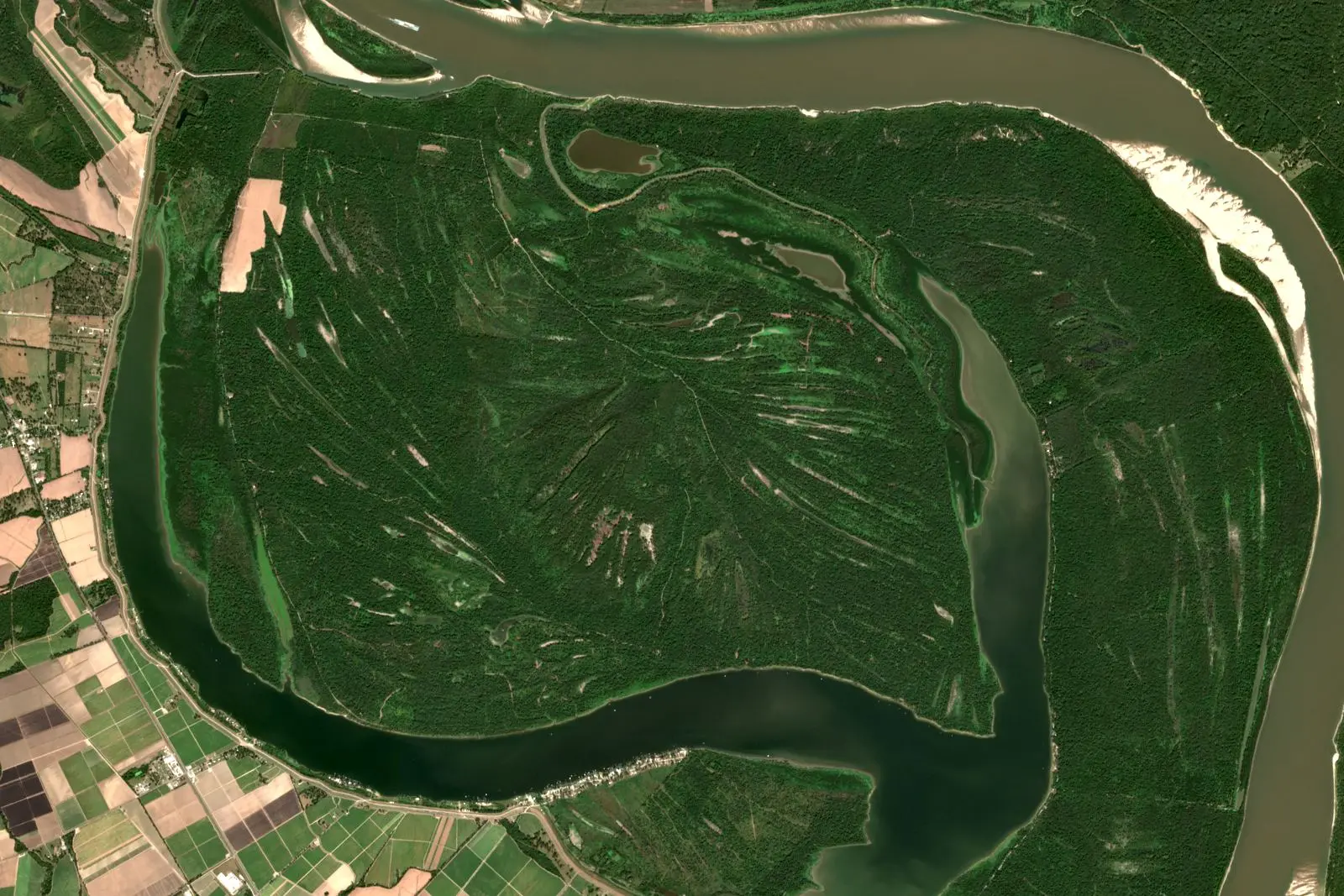
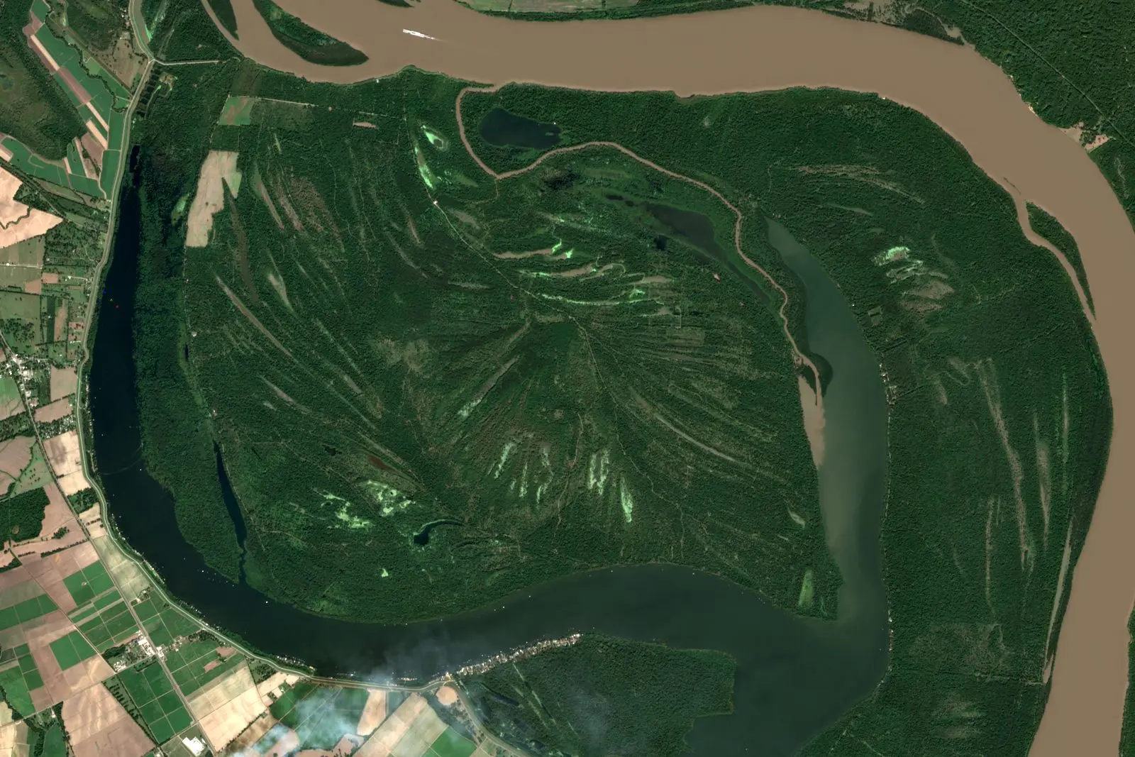
Raccourci Lake, Louisiana, on 21 October 2024 in Sentinel-2 true color. The lake curls around a forested point, with the Mississippi River along the top and right edges. North is up, with the image grid about 0.7° off true north.
Benchmark Sentinel-2 L2A scene S2A_T15RXQ_20241021T165322_L2A (sentinel-2-c1-l2a, baseline 05.11); bands 4-3-2 with one stretch 0.0123–0.2076, gamma 1.5; 10 m pixels, not enlarged; scale bar within 0.03% of the geodesic distance between its ends; north arrow at true north for the frame center.
Image
"Raccourci Lake (Old River), Louisiana true-color composite, Sentinel-2 L2A scene S2A_T15RXQ_20241021T165322_L2A via Earth Search (Element 84)" by Meridian & Moraine — https://earth-search.aws.element84.com/v1/collections/sentinel-2-c1-l2a/items/S2A_T15RXQ_20241021T165322_L2A — Copernicus Sentinel data legal notice (https://sentinels.copernicus.eu/documents/247904/690755/Sentinel_Data_Legal_Notice); modified: cropped, resampled, color-stretched; rights notice: Contains modified Copernicus Sentinel data 2024
Annotation layer
"Annotation layer for Raccourci Lake (Old River), Louisiana (2024)" by Meridian & Moraine, https://meridianandmoraine.com/satellite/oxbow-lake/, licensed under CC BY 4.0 (https://creativecommons.org/licenses/by/4.0/).
Beside a looping river lies a crescent of water cut off from the main channel. A crescent like that can mark a spot where the river got shorter by bending too far: two of its bends met, and the water took the short way across the land between them. A 1999 report from the U.S. Geological Survey (USGS) describes one such crescent, Raccourci Lake (Old River), about 25 miles northwest of Baton Rouge, Louisiana, as “an oxbow lake formed from an incomplete cutoff of the Mississippi River.”
How does a river make an oxbow lake?
The National Park Service (NPS) describes the process in its explanation of meandering streams, which wind back and forth across their valleys in a single channel. Around each bend, water along the outside moves faster than water along the inside. The faster current erodes the outer bank, leaving an erosional surface called a cut bank, while the slower current on the inside deposits sand and builds a point bar.
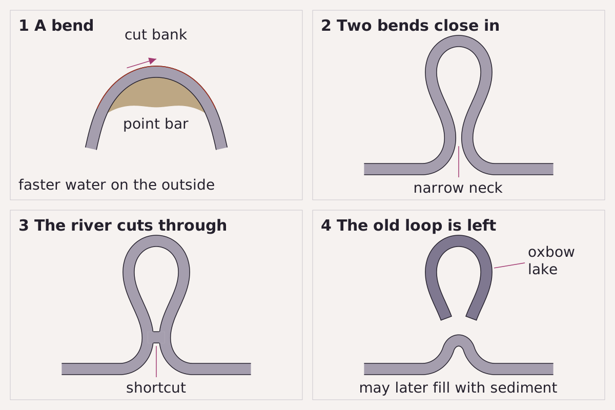
How a meander loop is cut off, in four steps: a bend with a cut bank outside and a point bar inside; two bends closing in; the river breaking through the neck; the old loop left as a lake.
Benchmark Schematic, not to scale; the steps follow the NPS description of a meandering stream.
"How a meander loop is cut off: four steps, schematic" by Meridian & Moraine, https://meridianandmoraine.com/satellite/oxbow-lake/, licensed under CC BY 4.0 (https://creativecommons.org/licenses/by/4.0/).
The bends do not stay in one place. According to NPS, a meander erodes sideways and slightly downstream, so each bend grows outward while it gradually migrates down the valley. In time, two loops can swing so close together that only a narrow strip of land, called the neck, still separates them. A 2021 study of the Ichilo River in Bolivia, summarized on its USGS publication page, uses the term neck cutoff for this kind of breakthrough and reports that neck cutoffs mainly control that river's meanders.
When the river finally breaks through the neck, it bypasses the loop and follows the shorter route. NPS calls the abandoned curve an oxbow lake and adds that it may then gradually fill with sediment. Seen from orbit, Raccourci Lake reads like a stroke the river once wrote in its cursive and later crossed out. The USGS report classifies the lake as the product of a cutoff; by the NPS description, that makes it a stretch of channel the river abandoned.
The USGS report does not explain what made the cutoff at Raccourci incomplete. It does state that the lake receives inflow from the Mississippi at its northeastern end, that it is hydraulically connected to the river, and that it lies inside the levee system along the river. Raccourci therefore stops short of the final panel in the figure above: a lake beside the main channel, still connected to it.
Why does the river get shorter?
NPS summarizes the geometry of a meandering stream in a single comparison: the distance “as the stream flows” is greater than the distance “as the crow flies.” Every additional loop adds channel length without carrying the water any farther down its valley.
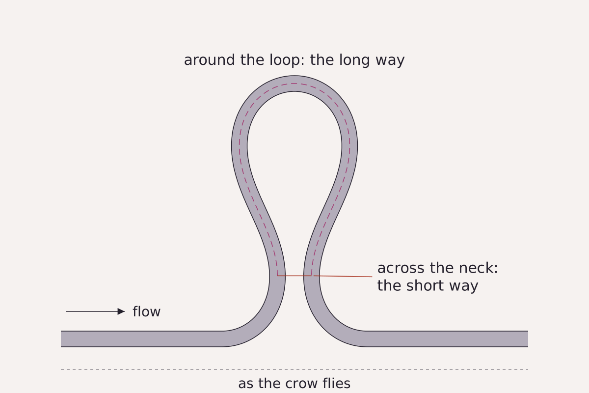
Two ways through the same loop: around it, the long way, and across the narrow neck, the short way. The dashed line along the bottom marks the distance as the crow flies.
Benchmark Schematic, not to scale; drawn to compare path lengths, not a measured cutoff.
"Around the loop or across the neck: two paths through one meander, schematic" by Meridian & Moraine, https://meridianandmoraine.com/satellite/oxbow-lake/, licensed under CC BY 4.0 (https://creativecommons.org/licenses/by/4.0/).
A cutoff removes that additional length in one step. Before the breakthrough, water travels all the way around the loop. Afterward it crosses the neck, a far shorter path than the loop it replaces. A loop that keeps growing until its two sides almost touch creates its own shortcut, and the river ends up shorter than before.
None of the sources consulted for this page gives a duration for a loop to grow and be cut off, or a date for the cutoff at Raccourci, so this page gives no number for how long the sequence takes. The USGS summary of the Ichilo River study points to a more useful measurement instead: the researchers analyzed the distance across the neck at two locations and used it to predict a new cutoff.
What does Raccourci Lake look like from orbit?
Sentinel-2, a European Earth-observation mission, records the visible and near-infrared bands used here in pixels 10 meters across. At that resolution Raccourci Lake is easy to read: a band of dark water, tens of pixels wide, curves around a forested point, while the brown water of the Mississippi runs along the top and right edges of the frame.
Open the image full size · annotation layer (SVG)
Image
"Raccourci Lake (Old River), Louisiana true-color composite, Sentinel-2 L2A scene S2B_T15RXQ_20181028T165138_L2A via Earth Search (Element 84)" by Meridian & Moraine — https://earth-search.aws.element84.com/v1/collections/sentinel-2-c1-l2a/items/S2B_T15RXQ_20181028T165138_L2A — Copernicus Sentinel data legal notice (https://sentinels.copernicus.eu/documents/247904/690755/Sentinel_Data_Legal_Notice); modified: cropped, resampled, color-stretched; rights notice: Contains modified Copernicus Sentinel data 2018
Annotation layer
"Annotation layer for Raccourci Lake (Old River), Louisiana (2018)" by Meridian & Moraine, https://meridianandmoraine.com/satellite/oxbow-lake/, licensed under CC BY 4.0 (https://creativecommons.org/licenses/by/4.0/).
Open the image full size · annotation layer (SVG)
Image
"Raccourci Lake (Old River), Louisiana true-color composite, Sentinel-2 L2A scene S2A_T15RXQ_20241021T165322_L2A via Earth Search (Element 84)" by Meridian & Moraine — https://earth-search.aws.element84.com/v1/collections/sentinel-2-c1-l2a/items/S2A_T15RXQ_20241021T165322_L2A — Copernicus Sentinel data legal notice (https://sentinels.copernicus.eu/documents/247904/690755/Sentinel_Data_Legal_Notice); modified: cropped, resampled, color-stretched; rights notice: Contains modified Copernicus Sentinel data 2024
Annotation layer
"Annotation layer for Raccourci Lake (Old River), Louisiana (2024, pair)" by Meridian & Moraine, https://meridianandmoraine.com/satellite/oxbow-lake/, licensed under CC BY 4.0 (https://creativecommons.org/licenses/by/4.0/).
Raccourci Lake on 28 October 2018 and on 21 October 2024, in Sentinel-2 true color with one shared stretch. Water levels at the two dates are not known to this page. This is not a before-and-after of a cut-off: the 1999 USGS report already described the lake as an oxbow. North is up, with the image grid about 0.7° off true north.
Benchmark Sentinel-2 L2A scenes S2B_T15RXQ_20181028T165138_L2A and S2A_T15RXQ_20241021T165322_L2A (sentinel-2-c1-l2a, baseline 05.00 and 05.11); bands 4-3-2 with one stretch 0.0123–0.2076, gamma 1.5, the same for both scenes; 10 m pixels, not enlarged; scale bar within 0.03% of the geodesic distance between its ends; north arrow at true north for the frame center.
The two scenes come from the same season, late October, six years apart, and they share one color stretch and one processing generation, so their colors can be compared directly. In both frames the lake's outline and the river's course look the same.
The surface is what differs. In 2018 the lake water appears darker and slightly greener, and a pale, smoke-like plume drifts across the agricultural fields at lower left. In 2024 a large pale patch appears on the inside of the Mississippi's bend at upper right, where the 2018 frame shows brown river water. Both differences are visible in imagery only; no source consulted for this page explains either one.
Neither scene is a before-and-after of a cut-off. The cutoff that created the lake happened before the 1999 survey, and therefore before either image was recorded, so two late-October views of the same lake document two days of water rather than the formation of an oxbow.
The ground-truth gap: what the image can and cannot prove
An image of a lake is not, on its own, evidence of how that lake formed. On Meridian & Moraine, the distance between what an image appears to show and what a published source supports is called the ground-truth gap. A reading crosses it only when a source supports the same place, the same landform and the same claim. Until then, a page describes only shape, color and position, and labels that description visible in imagery.
Open the image full size · annotation layer (SVG)
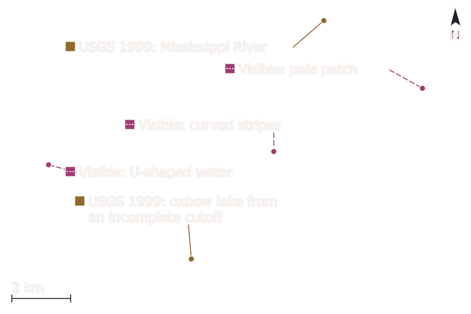
The 2024 scene with two kinds of marks. Rose squares and dashed leaders point to shapes visible in imagery; ocher squares and solid leaders point to claims that the 1999 USGS report supports for this place. North is up, with the image grid about 0.7° off true north.
Benchmark Sentinel-2 L2A scene S2A_T15RXQ_20241021T165322_L2A (sentinel-2-c1-l2a, baseline 05.11); bands 4-3-2 with one stretch 0.0123–0.2076, gamma 1.5; 10 m pixels, not enlarged; scale bar within 0.03% of the geodesic distance between its ends; north arrow at true north for the frame center.
Image
"Raccourci Lake (Old River), Louisiana true-color composite, Sentinel-2 L2A scene S2A_T15RXQ_20241021T165322_L2A via Earth Search (Element 84)" by Meridian & Moraine — https://earth-search.aws.element84.com/v1/collections/sentinel-2-c1-l2a/items/S2A_T15RXQ_20241021T165322_L2A — Copernicus Sentinel data legal notice (https://sentinels.copernicus.eu/documents/247904/690755/Sentinel_Data_Legal_Notice); modified: cropped, resampled, color-stretched; rights notice: Contains modified Copernicus Sentinel data 2024
Annotation layer
"Raccourci Lake, 2024: what is visible in imagery and what the 1999 USGS report supports" by Meridian & Moraine, https://meridianandmoraine.com/satellite/oxbow-lake/, licensed under CC BY 4.0 (https://creativecommons.org/licenses/by/4.0/).
The ocher marks cross the gap. The USGS report names this lake, maps it at this location, and states how it formed, as an oxbow lake from an incomplete cutoff of the Mississippi. The report also places the Mississippi River to the east of the lake, and in the image the channel along the top and right edges is one continuous river.
The rose marks stay on the near side. Inside the loop, thin pale stripes curve across the forest in long arcs, but no source consulted for this page explains them, so the label describes only what can be seen.
The same goes for the pale patch on the inside of the Mississippi's bend at upper right. NPS says that point bars build on the inside of bends, and the patch sits in that position, but position alone is not proof. Without a source for this bend on this date, the patch remains a pale shape, visible in imagery.
The image is also silent about some things the report does describe. According to the report, Raccourci takes in water from the Mississippi at its northeastern end. At 10-meter resolution, the frame does not show where that water enters, so the figure leaves that point unmarked. The same two-color approach returns at the Richat Structure, where concentric rings in the Sahara are compared with a published study.
Is Raccourci Lake shrinking?
The two scenes give the lake different areas. Measured as open water in 10-meter pixels, using a water index calculated from the satellite's green and near-infrared bands, the lake covered 18.71 km² (4,624 acres) on 28 October 2018 and 16.94 km² (4,185 acres) on 21 October 2024. Water levels at the two dates are not known to this page, so the decrease is not a trend.
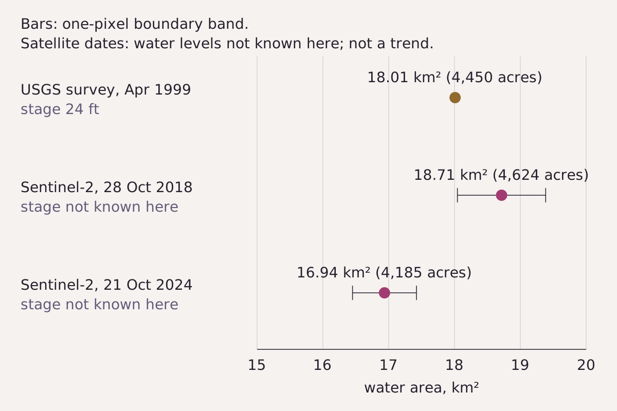
Water area of Raccourci Lake from the 1999 USGS survey and from two Sentinel-2 scenes. Whiskers reach out by the area of a one-pixel band around the lake's edge on each side of the value. Each value belongs to its own water level.
Benchmark Water area measured on both Sentinel-2 scenes at 10 m, with a one-pixel boundary band; compared with the 1999 USGS survey at a stage of 24 ft; water levels at the two dates are not known to this page.
"Raccourci Lake water area: USGS 1999 survey and two Sentinel-2 scenes" by Meridian & Moraine, https://meridianandmoraine.com/satellite/oxbow-lake/, licensed under CC BY 4.0 (https://creativecommons.org/licenses/by/4.0/).
| Date | Source | Water area | Against USGS 1999 | Lake water level |
|---|---|---|---|---|
| 13–16 Apr 1999 | USGS bathymetric survey | 18.01 km² (4,450 acres) | — | 24 ft above sea level |
| 28 Oct 2018 | Sentinel-2, this page's measurement | 18.71 km² (4,624 acres); boundary band 0.671 km² | +3.9% | not known to this page |
| 21 Oct 2024 | Sentinel-2, this page's measurement | 16.94 km² (4,185 acres); boundary band 0.486 km² | −6.0% | not known to this page |
Download the water areas (CSV) (about this file)
The USGS survey measured 4,450 acres in April 1999, when the lake surface stood 24 feet above sea level; against that figure, the 2018 value is 3.9% larger and the 2024 value is 6.0% smaller. The same report places the lake's normal low stage at 26 feet in summer and fall and says the lake typically rises above 40 feet in spring. A lake whose surface moves through more than 14 feet in a typical year does not keep a single outline.
The measurement has its own limits. A band one pixel wide around the edge of the lake covers 0.671 km² in 2018 and 0.486 km² in 2024, about 3.6% and 2.9% of each area. The 2018 difference from the USGS figure is roughly the size of that band. The difference between the two satellite dates, 1.78 km², is larger than the two bands combined, so by this page's measurement the 2024 scene records less open water, on that day and at that water level.
On whether oxbow lakes dry up, NPS says only that an oxbow lake may fill with sediment after the river abandons it, and it gives no timeline. Two scenes are far too few to reveal one. Raccourci, for its part, still receives water from the Mississippi, according to the 1999 report.
What do oxbows look like from a plane?
Satellites are not the only view from above. A 2010 aerial photograph mosaic from the U.S. Department of Agriculture covers the Red River in Lafayette and Miller counties, in southwestern Arkansas, in considerably finer detail than Sentinel-2 provides.
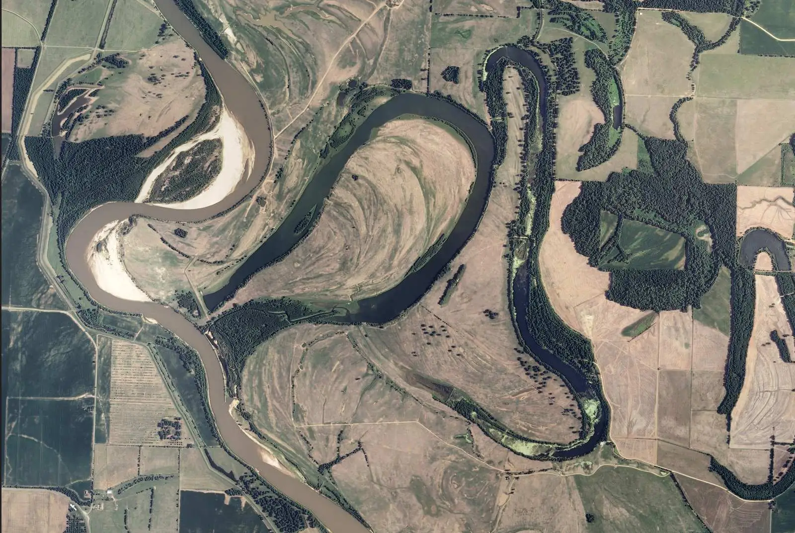
The Red River in southwest Arkansas in a 2010 USDA aerial photo mosaic. Brown water runs in the active channel at left; dark crescents of water lie beside it, separated from it by strips of land.
“Meandering course of the Red River in Lafayette and Miller counties, Arkansas, from the 2010 NAIP orthophoto mosaic”, USDA/FSA; public domain.
Full credit
"Meandering course of the Red River in Lafayette and Miller counties, Arkansas, from the 2010 NAIP orthophoto mosaic" by USDA/FSA — https://commons.wikimedia.org/wiki/File:RedRiverMeandersArkansas1.jpg — Public domain (US: U.S. Government work (17 U.S.C. §105), USDA Farm Service Agency NAIP orthophoto; EU: no copyright term is claimed for this U.S. federal work, and the file carries the Public Domain Mark 1.0); modified: cropped, resized
Three clues separate the active channel from the crescents. The river water is brown; the crescents are dark. Pale patches occupy the insides of the river's bends, the position that NPS describes for point bars, and none of the crescents visibly joins the brown channel in this frame.
Those crescents have the shape that NPS describes for oxbow lakes. But no survey of these particular lakes was consulted for this page, so here they remain crescent-shaped water, visible in imagery: strong candidates rather than confirmed readings. Curved lines also cross the fields inside the loops, similar to the stripes at Raccourci, and they remain unexplained for the same reason.
How a valley floor like this one is colored on a geologic map is a separate reading, done along the lines where two colors meet.
How do you spot the next oxbow?
The Ichilo River study suggests where to look. According to its USGS summary, the researchers analyzed the distance across the neck at two locations where cutoffs were expected and used that distance to predict a new one. A narrowing neck is also the starting condition in the NPS description of a cutoff.
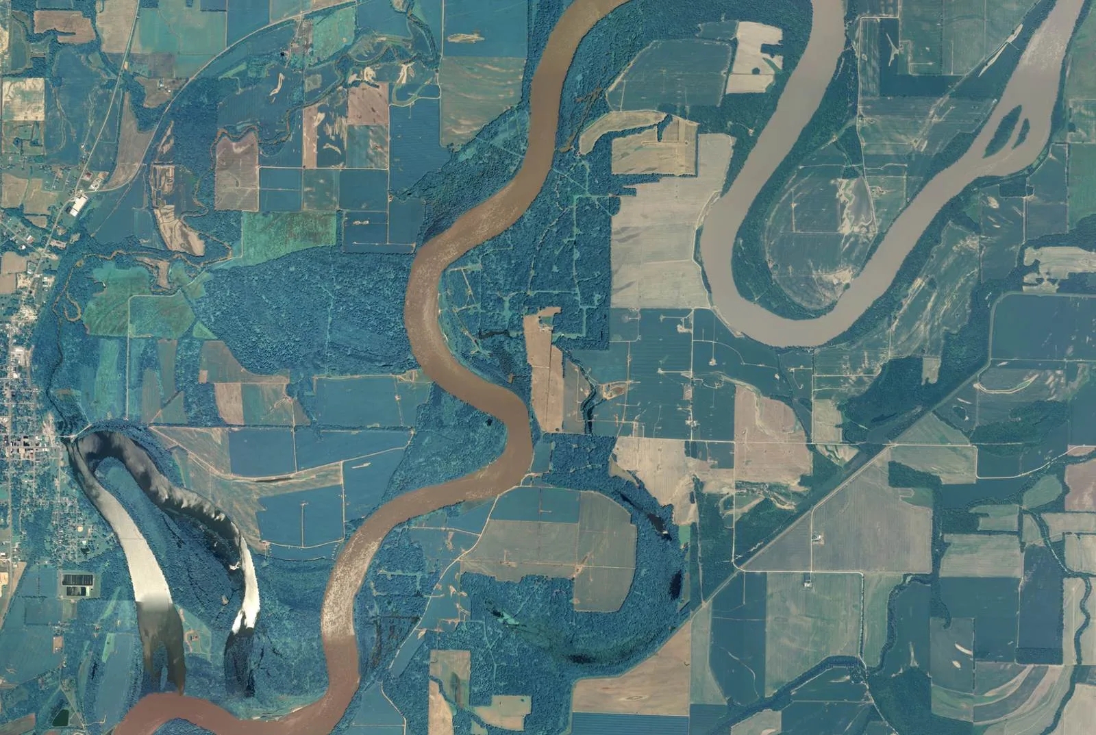
The Wabash River near Grayville, Illinois, in a 2010 USDA aerial photo mosaic. At upper right the river swings around a long loop whose two sides run fairly close; at lower left a crescent of water curves away from the channel, which it joins at its southern end.
"Meanders of the Wabash River at Grayville, Illinois, from 2010 NAIP aerial imagery" by USDA/FSA — https://commons.wikimedia.org/wiki/File:Wabash_River_Meanders_Grayville,_Illinois.jpg — Public domain (US: U.S. Government work (17 U.S.C. §105), USDA NAIP aerial imagery; EU: no copyright term is claimed for this U.S. federal work, and the file carries the Public Domain Mark 1.0); modified: cropped, resized
A map or a satellite view can be examined for the same signs, in this order:
- Trace the main channel from one edge of the image to the other and identify each loop along the way.
- At every loop, find the place where its two sides come closest together; that strip of land is the neck.
- Compare the necks across the image, since the width of a neck is the measurement the Ichilo researchers analyzed.
- Look beside the channel for crescents of still water, or for bands of trees that follow the same curve as the river's bends, because these are candidates for abandoned loops.
- Before calling any candidate an oxbow, look for a published source that identifies it at that location.
On the next map of a winding river, run a finger along the channel and stop wherever two bends nearly touch. That strip of land is where the river may eventually take its next shortcut, and any crescent of still water beside it is a reading to check against a source before calling it an oxbow.
Next overpass
- Contour lines: the same kind of river valley drawn as contour lines, where a V pointing uphill marks the stream.
- Alluvial fan: another shape that running water builds, this time at the foot of desert mountains.
Sources
- Paul A. Ensminger, Bathymetric Survey and Physical and Chemical-Related Properties of Raccourci Lake, Louisiana, July 1998 and April 1999, U.S. Geological Survey Water-Resources Investigations Report 99-4292 (Baton Rouge, Louisiana: U.S. Geological Survey, 1999), 1 sheet. pubs.usgs.gov/wri/1999/4292/wri994292.pdfRead: full text of the one-sheet report
- U.S. National Park Service, "Fluvial Features—Meandering Stream," last updated April 22, 2020. www.nps.gov/articles/meandering-stream.htmRead: full text
- Kattia Rubi Arnez Ferrell, Jonathan M. Nelson, Yasuyuki Shimizu and Tomoko Kyuka, "Past, present and future of a meandering river in the Bolivian Amazon basin," Earth Surface Processes and Landforms (2021), doi:10.1002/esp.5058. www.usgs.gov/publications/past-present-and-fut…Read: abstract only
- Copernicus Sentinel-2 Level-2A, Collection 1 (sentinel-2-c1-l2a), scenes S2B_T15RXQ_20181028T165138_L2A and S2A_T15RXQ_20241021T165322_L2A, distributed through Earth Search by Element 84. earth-search.aws.element84.com/v1/collections/sentinel-2-c1-l2a/…Read: scene metadata and image data for two scenes
Cite this page
The Reading Room. “Oxbow Lake: A River Gets Shorter by Bending Too Far.” Meridian & Moraine, published 16 November 2026. https://meridianandmoraine.com/satellite/oxbow-lake/. Accessed on the date you read it.
How readings are checkedAll correctionsReport an error on this page (contact@meridianandmoraine.com)
More from Read from Orbit
Read from Orbit
Alluvial Fan: In Death Valley, Dark Is Older, Up to a Point
Image credit
"Death Valley Alluvial Fan from Dante's View" by Wilson44691 — https://commons.wikimedia.org/wiki/File:Death_Valley_Alluvial_Fan_from_Dante%27s_View.JPG — CC0 1.0 (https://creativecommons.org/publicdomain/zero/1.0/); modified: cropped, resized
 Illustration
Read from Orbit
Atmospheric River: Moving Water Vapor, Not a River of Cloud
Image credit (illustration)
Illustration: Meridian & Moraine. Generated illustration — not a photograph, satellite image or map; not to scale. Reuse: CC BY 4.0 (https://creativecommons.org/licenses/by/4.0/) to the extent any rights apply.
Read from Orbit
Richat Structure: A Worn-Down Dome, Not an Impact Crater
Image credit
"Richat Structure, Adrar, Mauritania true-color composite, Sentinel-2 L2A scene S2A_T29QKD_20240126T111440_L2A via Earth Search (Element 84)" by Meridian & Moraine — https://earth-search.aws.element84.com/v1/collections/sentinel-2-c1-l2a/items/S2A_T29QKD_20240126T111440_L2A — Copernicus Sentinel data legal notice (https://sentinels.copernicus.eu/documents/247904/690755/Sentinel_Data_Legal_Notice); modified: cropped, resampled, color-stretched; rights notice: Contains modified Copernicus Sentinel data 2024